
Eight Mile Plains, Queensland facts for kids
Quick facts for kids Eight Mile PlainsBrisbane, Queensland |
|||||||||||||||
|---|---|---|---|---|---|---|---|---|---|---|---|---|---|---|---|

Former and current alignment of Logan Road, 2013
|
|||||||||||||||

Eight Mile Plains
Location in Queensland
|
|||||||||||||||
| Population | 15,326 (2021 census) | ||||||||||||||
| • Density | 1,965/km2 (5,090/sq mi) | ||||||||||||||
| Established | 1864 | ||||||||||||||
| Postcode(s) | 4113 | ||||||||||||||
| Area | 7.8 km2 (3.0 sq mi) | ||||||||||||||
| Time zone | AEST (UTC+10:00) | ||||||||||||||
| Location | 14.9 km (9 mi) SSE of Brisbane CBD | ||||||||||||||
| LGA(s) | City of Brisbane (MacGregor Ward) |
||||||||||||||
| State electorate(s) |
|
||||||||||||||
| Federal Division(s) | |||||||||||||||
|
|||||||||||||||
Eight Mile Plains is a lively suburb located in the southern part of Brisbane, Queensland, Australia. It's a place where many families live and work. In 2021, about 15,326 people called Eight Mile Plains home.
Contents
Exploring Eight Mile Plains
Eight Mile Plains is about 14.9 kilometres (or 9 miles) south-southeast of Brisbane's city centre.
A creek called Bulimba Creek flows along the northern and western edges of the suburb. Major highways like the Gateway Motorway and the Pacific Motorway also mark some of its borders.
Eight Mile Plains has natural beauty, including Bulimba Creek. Before European settlement, the area was full of different plants and animals. Today, you can still find areas of natural bushland and some small farms.
The Queensland Government created the Brisbane Technology Park here. It's a special area designed to help new and growing technology companies work together.
A Look Back: History of Eight Mile Plains
The name "Eight Mile Plains" was given a long time ago. It describes how flat the land is and how far it was (8 miles) from a place called One Mile Swamp (which is now Woolloongabba).
Early Days and First People
We're not entirely sure which Aboriginal group lived here first. Some say it was the Chepara clan, who spoke the Turrbal language. Others believe it was the Yagarabal people. These groups used a path that later became Logan Road. This path crossed many creeks, including Mimosa Creek and Bulimba Creek.
Farming and Growth
In 1864, the Eight Mile Plains Agricultural Reserve was created. This large area included what are now the suburbs of Sunnybank, Sunnybank Hills, Runcorn, Kuraby, Eight Mile Plains, and parts of other suburbs.

In 1863, Charles Baker bought land here and opened Baker's Hotel in 1865. Later, it became the Eight Mile Plains Hotel. In 1875, it was a stop for the famous Cobb & Co coaches. In 1927, two sisters, Mary-Jane McCamey and Emma O’Sullivan, took over. They renamed it "The Glen" because the rolling hills reminded them of Scotland. They even started wood chopping competitions, which led to the creation of the Queensland Axeman's Association! The Glen Hotel is still open today, making it one of Queensland's oldest hotels.
Schools and Community

The Eight Mile Plains Provisional School first opened on 7 June 1869. It was in Charles Baker's paddock on Logan Road. About 15 students attended then. By 1875, there were 80 students, and people wanted a new school in a better spot. A new building was built in 1880. In 1896, it became Eight Mile Plains State School. The school moved to its current location in 1958.
In the early 1900s, different churches (Anglican, Catholic, Lutheran, and Methodist) decided to share one church building on Millers Road. They took turns holding services there. Eventually, it became St Paul's Anglican Church.

St Johns Lutheran Church was built by volunteers and opened in 1951. It was designed by a farmer named Reg Waldman, who also helped build it and played the organ!
Warrigal Road State School opened on 30 January 1979. The word Warrigal means "Dingo" in the local Aboriginal language.
Changing Borders
Originally, Eight Mile Plains was bigger. In the 1970s, some parts of it became new suburbs like Underwood and parts of Rochedale.
In 1986, the Brisbane Technology Park opened. It's a large area for science and industry, just 12 minutes from Brisbane's city centre.
Eight Mile Plains has become more diverse over the years. A Sikh Temple was built on Logan Road in 1988, and a Bosnian Mosque opened in 2014.
Who Lives Here?
In 2021, Eight Mile Plains had a population of 15,326 people.
The 2016 Census showed that 43.4% of people in Eight Mile Plains were born in Australia. Other common birthplaces included China (12.2%), South Korea (6.4%), Taiwan (4.9%), and India (5.3%).
Many different languages are spoken at home. While 42.7% spoke only English, other popular languages included Mandarin (19.1%), Korean (7.3%), and Cantonese (6.3%). Eight Mile Plains has the largest Korean Australian community in Queensland.
Important Places: Heritage Sites
Eight Mile Plains has some special places listed for their historical importance:
- 24 Levington Road: St Johns Lutheran Church
- 2497 Logan Road: Hughesville
- 17 Millers Road: United Protestant Church
Hughesville
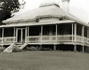
Hughesville is a beautiful old house built in 1892–93. It was built by Alfred Hughes, a local horse dealer. This timber house shows what homes looked like in Queensland a long time ago. It's known for its classic style and how well it has been kept. For many years, it was a famous landmark along the old Pacific Highway, showing people they were reaching the edge of Brisbane. Today, the land around it has been developed, and the house itself is now used for businesses. Hughesville was added to the Queensland Heritage Register in 1992.
Learning in Eight Mile Plains

Eight Mile Plains State School is a government primary school for students from Prep to Year 6. It's located at 480 Underwood Road. In 2017, about 271 students attended the school. It also has a special education program.

Warrigal Road State School is another government primary school for students from Prep to Year 6. It's at 314 Warrigal Road. In 2017, it had a larger enrolment of 1283 students and also offers a special education program.
There are no high schools directly in Eight Mile Plains. Students usually go to secondary schools in nearby suburbs like Runcorn, Sunnybank, or MacGregor.
Getting Around
Eight Mile Plains is well-connected by major roads. The Pacific Motorway links it to Brisbane's city centre and the Gold Coast. The Gateway Motorway connects it to the Sunshine Coast.
You can also use public transport. The Eight Mile Plains busway station is part of the South-East Busway, making it easy to travel by bus.
Famous Faces from Eight Mile Plains
Some notable people have lived in Eight Mile Plains:
- Charles Baker: He bought land here in 1857 and later built a hotel. He also became the postmaster.
- Sam Langford: He owned a large farm called the 'wire paddock' because it was the first to be fenced that way. He later sold parts of his land for housing.
- Des O'Reilly: A rugby league player who won a championship with the Eastern Suburbs Roosters in 1975.
- Estelle Thomson: A naturalist and talented botanical illustrator.
- Kym Tollenaere: An Australian softball catcher.
