
University District, Seattle facts for kids
Quick facts for kids
University District
|
|
|---|---|
|
Seattle Neighborhood
|
|

The U-District, looking northeast from Queen Anne. UW Tower is the tall building in the center, with the Hotel Deca (originally the Meany Hotel) to its left. The I-5 Ship Canal Bridge is in the foreground.
|
|

Map of the University District's location in Seattle
|
The University District, often called the U District, is a group of neighborhoods in Seattle, Washington. It gets its name because the main campus of the University of Washington (UW) is located there. The university moved here two years after the area became part of Seattle. At that time, much of the land was still covered in forests or had farms with tree stumps. The U District grew with the university, becoming like a smaller city within Seattle.
This area includes several smaller neighborhoods. These are University Park, Greek Row (where many fraternity and sorority houses are), University Heights, and the Brooklyn Addition. It also includes the main, west, and south campuses of the University of Washington.
Contents
Exploring the U District's Location
The U District's borders are not officially set, but people generally agree on them. To the west, it's bordered by Interstate 5. To the east, it goes up to 25th Avenue NE. The Lake Washington Ship Canal forms its southern edge, and NE Ravenna Boulevard is its northern border.
There's also a small part of the U District east of these main borders. This section is on the north side of Union Bay. It stretches north to NE 45th Street and east to 35th Avenue NE. This part mainly has the "east campus" of the University and large parking areas. The main shopping street in the U District is University Way NE. People all over Seattle call it "The Ave".
Some parts of the U District used to have their own names. For example, "University Heights" now mostly refers to a former school building. This building is now a community center called the University Heights Center for the Community. An old map from 1905 shows that "University Heights" was once the name for a specific area.
A Look Back: History of the U District

People have lived in the area that is now the University District for a very long time. They arrived after the last Ice Age, about 10,000 years ago. Important Native American villages of the Duwamish tribe were located here. These villages were part of the Coast Salish nations. One village was on Portage Bay, near what is now Brooklyn Avenue. Another was on Union Bay, close to where the UW power plant is today.
The Duwamish tribe had a main village called SWAH-tsoo-gweel on Union Bay. This name means "portage," referring to a place where boats or canoes could be carried over land. The area now known as Ravenna was like their backyard before European settlers arrived. People lived in spread-out villages. In spring, they would leave their winter homes (longhouses) to go to camps. They would gather in summer to catch salmon. They also kept open areas in the forest. This helped encourage game animals and grow food supplies. These open areas, like grasslands, were grown in what is now the University District. Paths connected these areas, including one along what is now the Lake Washington Ship Canal.
Early surveyors noticed very large Douglas-firs and western red cedars here. The U District was first surveyed in 1855. The first white settlers arrived 12 years later. In 1890, the part of the neighborhood west of the UW campus was named the Brooklyn Addition. One year later, much of the land north of the Ship Canal, including Brooklyn, became part of Seattle. The University of Washington moved from Downtown in 1893. The first university building was finished in 1895.
An old report from 1894 describes a train accident just west of the current University District.
.jpg)
The name "Brooklyn" slowly disappeared after the university moved. Electric trolley tracks were put on Columbus Avenue (which later became 14th Avenue) in 1892. The neighborhood soon became known as "University Station." This was because of a heated waiting house at the corner of what is now NE 42nd Street. However, the name Brooklyn is not completely gone. Brooklyn Avenue NE runs next to University Way, one block to the west. North and west of the campus, within the U District, is the University Heights area. This name is not used much anymore. It was named after its elementary school, which was open from 1903 to about 1988. Since 1990, the building has been the University Heights Center for the Community. It hosts many events, from community clean-ups to the University District Farmer's Market.
In the early days, getting from the U District to Downtown Seattle was hard. It involved a long walk, a boat ride, and a horse cart. Because of these travel difficulties, the U District was mostly self-sufficient. It had local businesses that served people connected to the University. More family homes were built in the early 1900s. Churches, theaters, stores, and a YMCA also appeared. The district's first bank and its first local public library opened in 1906. The library was a small one, started by local business owners.
In 1919, a contest was held by the University Commercial Club. As a result, 14th Avenue (already known as "The Avenue" or "The Ave") was renamed University Way. The neighborhood itself was renamed the University District. The main north-south streets in the neighborhood are Roosevelt Way NE, 11th Avenue NE, Brooklyn Avenue NE, University Way NE, and 15th Avenue NE. NE Pacific, 45th, and part of 50th streets are the main east-west streets. NE Campus Parkway is a smaller east-west street that only runs west of the campus.
The U District Today

Every May, the U District hosts an annual street fair. This fair started in 1971 and was the first of its kind. It was begun by a local business owner and peace activist named Andy Shiga. The University District Farmers Market is also held here. It was Seattle's first farmers-only market, starting in 1993, and it's the largest neighborhood market of its kind. Andy Shiga (1919–1993) and local lawyer Calmar McCune (1911–1996) helped support the unique character of the U District for a long time.
The ASUW Experimental College was founded in 1968 by UW students. They wanted to learn about topics not taught in traditional university classes. It is now the largest student-run program of its kind that is not for profit. It is open to everyone and has added to the U District's culture ever since. The Blue Moon Tavern has been an important cultural spot since 1934. Big Time is Seattle's first brewpub, opening in 1988. Dante's Bar&Nightclub, which opened in 1966, is another popular place and is known as a "U-District tradition."
The neighborhood also has six theaters. These include the Neptune, built in 1921, and the Varsity, open since 1940. The Grand Illusion Cinema started in 1968 and is now run by volunteers. Scarecrow Video, which is locally owned, is the largest video store on the West Coast. These places add to the neighborhood's unique feel.
The tallest buildings in the U District, besides the UW campus, are important landmarks. These are UW Tower and the Meany Hotel. UW Tower used to be called Safeco Plaza. It is located at the corner of Brooklyn Avenue NE and NE 45th Street. It was built in 1973 and is 22 stories high. This makes it the tallest building in Seattle outside of Downtown. The Meany Hotel, now known as the Graduate Seattle, is an Art Deco style building from 1931. The architect, Robert Reamer, designed every room to have a corner window. A beautiful building in the neighborhood is the formal Neo-classical Carnegie Library. It was built in 1910 and is on Roosevelt Way at 50th Street.

In recent years, the University District has faced some challenges. Other shopping areas like University Village (east of the campus) and Northgate Mall (north of I-5) have become more popular. From 2002 to 2004, the city and the neighborhood worked to improve "The Ave." They repaved the street, added benches, and put in new lighting. Adding benches was a change, as for many years there had been fewer places to sit.
The U District now has two Link light rail stations. The University of Washington Station near Husky Stadium opened in 2016. The U District station on Brooklyn Avenue near NE 45th Street opened in October 2021. Light rail service connects the U District to Capitol Hill, Downtown Seattle, and Sea-Tac Airport. The area around the U District Station was changed in 2017 to allow for taller buildings. As of 2020, 12 new tall buildings are planned to start construction.
The U District is home to all of the UW's fraternity and sorority houses. Most of them are grouped along 17th Avenue NE between NE 45th and 50th Streets. This area is often called "Frat Row" or "Greek Row."
Images for kids
-
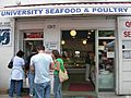
University Seafood and Poultry, founded 1945, closed 2020.
-
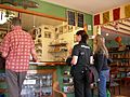
The Wannabee, one of the U. District's many independent coffeehouses (2006).
-
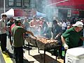
University District Street Fair, 2007.


