
Voeren facts for kids
Quick facts for kids
Voeren
Fourons (French)
|
|||
|---|---|---|---|

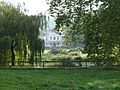
Sint-Martens-Voeren
|
|||
|
|||

Voeren
Location in Belgium
|
|||
| Country | Belgium | ||
| Community | Flemish Community | ||
| Region | Flemish Region | ||
| Province | Limburg | ||
| Arrondissement | Tongeren | ||
| Area | |||
| • Total | 50.63 km2 (19.55 sq mi) | ||
| Population
(2018-01-01)Lua error in Module:Wd at line 1575: attempt to index field 'wikibase' (a nil value).
|
|||
| • Total | Lua error in Module:Wd at line 1,575: attempt to index field 'wikibase' (a nil value). | ||
| Postal codes |
3790, 3791, 3792, 3793, 3798
|
||
| Area codes | 04 | ||
| Website | www.voeren.be | ||


Voeren (also known as Fourons in French) is a special municipality in Belgium. It is located in the Limburg province, which is part of Flanders. Most people in Voeren speak Dutch. However, because of its history, it also has special rules to help its French-speaking residents.
Voeren is unique because it's like an island of Flanders. It's not directly connected to the rest of Flanders. Instead, it's surrounded by the Netherlands to the north and the Liège Province of Wallonia to the south. The name Voeren comes from a small river called the Voer, which flows through the area.
The municipality of Voeren was created in 1977. As of 2008, about 4,207 people lived there. The total area of Voeren is about 50.63 square kilometers (19.55 square miles). This means there are about 83 people living in each square kilometer. Around 25% of the people living in Voeren are from other countries, mostly from the Netherlands.
Villages of Voeren
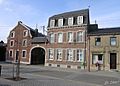
The municipality of Voeren is made up of six different villages. Each village has its own charm and history.
The six villages are:
- 's-Gravenvoeren (also called Fouron-le-Comte)
- Sint-Pieters-Voeren (also called Fouron-Saint-Pierre)
- Sint-Martens-Voeren (also called Fouron-Saint-Martin)
- Moelingen (also called Mouland)
- Teuven
- Remersdaal (also called Rémersdael)
Among these, 's-Gravenvoeren is the largest and most important village in the municipality. Sometimes, people locally use shorter names for the three "Sint" villages: Sint-Marten, Sint-Pieter, and Voeren (for 's-Gravenvoeren).
History of Voeren
The history of Voeren is quite interesting, with different rulers and changes over time.
For many centuries, starting from the 11th century, the land that is now Voeren was split. Two-thirds of it belonged to the county of Dalhem, and the other third was part of the Duchy of Limburg. Both of these areas were controlled by the dukes of Brabant. These duchies were part of a larger area called the Holy Roman Empire, but they often acted quite independently.
Over time, these lands became part of bigger groups of territories:
- The Burgundian Netherlands
- The Habsburg Netherlands
- The Southern Netherlands (controlled by Spain, then Austria)
During the time when France was led by Napoleon (from 1794 to 1815), the old borders were changed. Voeren became part of a French area called the "Ourthe department." After Napoleon's defeat, this area became the modern Liège Province in Belgium.
A big change happened in 1963. The Voer Region, which included Voeren, was moved from Liège Province to Limburg Province. This meant Voeren became part of Flanders, the Dutch-speaking region of Belgium.
Gallery
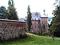
-
Altembrouck castle at 's Gravenvoeren
-
Remersdaal
-

Teuven
-
Moelingen
-
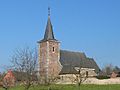
Sint-Pieters-Voeren church
-
Sint-Pieters-Voeren castle


See also
 In Spanish: Voeren para niños
