
Wahoo Creek-Little River (Chattahoochee River tributary) facts for kids
The Wahoo Creek-Little River area is like a big funnel for water in northeastern Georgia. It's called a watershed, which means it's an area of land where all the rain and snowmelt drain into a common body of water. In this case, all the water from three main streams and their smaller branches flows into Lake Lanier north of Gainesville.
The three main streams are Wahoo Creek, West Fork Little River, and East Fork Little River. They all start in the southwestern part of White County, near U.S. Route 129. From there, they flow through Lumpkin County and Hall County before reaching Lake Lanier. This watershed is part of a much larger water system called the Upper Chattahoochee sub-basin, which is part of the huge Apalachicola basin.
Contents
What is the Wahoo Creek-Little River Watershed?
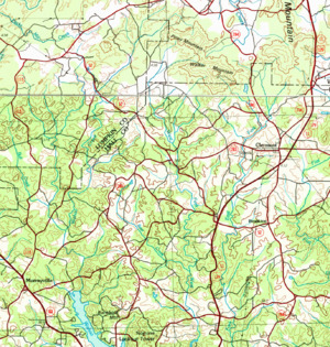
The Wahoo Creek-Little River watershed is a special area identified by the United States Geological Survey. It's known as HUC 0313000104. This watershed covers about 87 square miles, which is a pretty big area!
It stretches from southwestern White County, following different roads and landmarks. Imagine drawing a big circle on a map: it starts near State Route 115 and State Route 284, goes down through towns like Murrayville and Price, and then follows roads like State Route 136 and State Route 60 towards Thompson Bridge. From there, it goes east along Thompson Mill Road, then follows U.S. Route 129 and State Route 284 north to Clermont, finally connecting back to State Route 115.
Main Sections of the Watershed
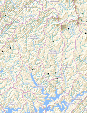
The Wahoo Creek-Little River watershed is actually made up of four smaller sections, called sub-watersheds. Let's explore them one by one, moving around the area like the hands of a clock.
Wahoo Creek Sub-watershed
Wahoo Creek starts in White County, not far from where State Route 115 and State Route 284 meet. It flows north, then west, and then southwest. After about a mile, it crosses into Lumpkin County.
It continues southwest for about 2.8 miles until it crosses State Route 52, where it turns south. Wahoo Creek flows south for about 6 miles. Then, another creek called Bull Creek joins it from the west. Wahoo Creek continues south for another 2.5 miles. Finally, it flows into Lake Lanier near Murrayville, at the northern part of the lake. Wahoo Creek is about 13.13 miles (21.13 km) long.
This area is known as sub-HUC 031300010401. It's the westernmost of the three main stream sub-watersheds and covers about 25 square miles.
West Fork Little River Sub-watershed
The West Fork Little River also begins in White County, close to where Wahoo Creek starts. It flows west, then turns south around Walker Mountain. After about 1.6 miles, it enters Hall County.
It continues south for about 3.2 miles, picking up water from smaller streams. It crosses State Route 52 where it meets State Route 283. The West Fork Little River keeps flowing south for about 7 more miles. It then flows into Lake Lanier between State Route 283 and U.S. Route 129. This creek is about 12.63 miles (20.33 km) long.
This sub-watershed is called sub-HUC 031300010402. It's the middle of the three stream sub-watersheds and covers about 21 square miles.
East Fork Little River Sub-watershed
The East Fork Little River forms when two creeks, Head Mill Creek and Eubank Creek, join together in Hall County, near Clermont. Both of these smaller creeks start in White County, east of Walker Mountain.
The river fork flows south, crossing State Route 283 and U.S. Route 129. It continues south, crossing State Route 52. The East Fork Little River then flows alongside US 129 for about 6.3 miles. It finally flows into Lake Lanier where US 129 crosses that part of the lake. This creek is about 10.56 miles (16.99 km) long.
This sub-watershed is known as sub-HUC 031300010403. It's the easternmost of the three stream sub-watersheds and covers about 18 square miles.
Little River-Lake Sidney Lanier Sub-watershed
This last sub-watershed includes the parts of Lake Lanier where Wahoo Creek, West Fork Little River, and East Fork Little River flow in. It covers the lake arms and the land between them. One other creek, Squirrel Creek, also flows into the Wahoo Creek arm of the lake from the west. Thompson Bridge and State Route 60 mark the southern edge of this area.
This part of the watershed is called sub-HUC 031300010404. It covers about 23 square miles and is the southernmost section of the entire Wahoo Creek-Little River watershed system.
