
Walpole (CDP), New Hampshire facts for kids
Quick facts for kids
Walpole, New Hampshire
|
|
|---|---|

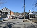
Westminster Street in the center of Walpole
|
|

Walpole (CDP), New Hampshire
Location in New Hampshire

Walpole (CDP), New Hampshire
Location in the United States
|
|
| Country | United States |
| State | New Hampshire |
| County | Cheshire |
| Town | Walpole |
| Area | |
| • Total | 1.23 sq mi (3.18 km2) |
| • Land | 1.22 sq mi (3.15 km2) |
| • Water | 0.01 sq mi (0.03 km2) |
| Elevation | 397 ft (121 m) |
| Population
(2020)
|
|
| • Total | 573 |
| • Density | 470.83/sq mi (181.77/km2) |
| Time zone | UTC-5 (Eastern (EST)) |
| • Summer (DST) | UTC-4 (EDT) |
| ZIP code |
03608
|
| Area code(s) | 603 |
| FIPS code | 33-78340 |
| GNIS feature ID | 2629744 |
Walpole is a small community in New Hampshire, United States. It is known as a census-designated place (CDP). This means it is a specific area identified by the U.S. Census Bureau for collecting population data. Walpole is the main village within the larger town of Walpole.
In 2020, about 573 people lived in the Walpole CDP. The entire town of Walpole, which includes this village and other areas, had a population of 3,633 people.
Contents
Exploring Walpole's Location
Walpole CDP is located in the western part of the town of Walpole. It sits on the eastern side of the Connecticut River valley. This river forms part of the border between New Hampshire and Vermont.
How Big is Walpole CDP?
The Walpole CDP covers a total area of about 3.2 square kilometers (1.2 square miles). Most of this area is land. Only a small part, about 0.03 square kilometers (0.01 square miles), is water.
Main Roads and Nearby Towns
New Hampshire Route 12 is an important road that runs through Walpole. It goes north to North Walpole, which is about 4.5 miles away. From North Walpole, you can cross the Connecticut River into Bellows Falls, Vermont. Route 12 also leads to Charlestown, about 11 miles north.
If you head south on Route 12, you will reach Keene, which is about 17 miles away. Another road, New Hampshire Route 123, starts near the center of Walpole. It goes west across the Connecticut River to Westminster, Vermont.
Who Lives in Walpole?
The population of Walpole CDP changes over time. In 2010, there were 605 people living here. By 2020, the population had slightly decreased to 573 people.
Diversity in Walpole
Most people living in Walpole CDP are White. A small number of residents identify as Asian or as having two or more races. Some people also identify as Hispanic or Latino.
Households and Families
In 2010, there were 315 households in Walpole CDP. A household is a group of people living together in one home. About 15.6% of these households had children under 18 living with them. Many households were made up of married couples. Some households had a female head without a husband present. Almost half of the households were non-families, meaning they were individuals living alone or unrelated people living together.
Age Groups in the Community
The people in Walpole CDP are of various ages. In 2010, about 13.1% of the population was under 18 years old. A larger group, 26.9%, was 65 years old or older. The median age was 53.0 years, which means half the people were younger than 53 and half were older.
Understanding Income
From 2011 to 2015, the estimated average yearly income for a household in Walpole CDP was about $46,061. For families, the average income was higher, around $85,278. The per capita income (income per person) was about $35,659.
Images for kids
-
Westminster Street in the center of Walpole
See also
 In Spanish: Walpole (condado de Cheshire) para niños
