Ward Island (California) facts for kids

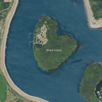
USGS aerial imagery of Ward Island, with Medford Island to its west, Empire Tract to its northeast, and Tinsley Island to its southeast.
|
|
| Geography | |
|---|---|
| Location | Northern California |
| Coordinates | 38°02′30″N 121°30′09″W / 38.04167°N 121.50250°W |
| Adjacent bodies of water | Sacramento–San Joaquin River Delta |
| Highest elevation | 7 ft (2.1 m) |
| Administration | |
|
United States
|
|
| State | |
| County | San Joaquin |
Ward Island, sometimes called Wards Island, is a small piece of land in the Sacramento–San Joaquin River Delta in California. It's located in San Joaquin County.
The island's exact location is 38°02′30″N 121°30′09″W / 38.04167°N 121.50250°W. In 1981, the United States Geological Survey (USGS) measured its elevation. This means how high it is above sea level. Ward Island is about 7 ft (2.1 m) above sea level.
What is the Sacramento–San Joaquin River Delta?
The Sacramento–San Joaquin River Delta is a large area where the Sacramento River and San Joaquin River meet. These rivers then flow into San Francisco Bay. It's a very important natural area.
Why is the Delta important?
The Delta is a mix of rivers, channels, and islands. It provides water for farms and cities all over California. Many different kinds of plants and animals also live there.
It's a special place for wildlife. You can find many types of fish, birds, and other creatures. The Delta is like a giant wetland, which is a habitat for many species.


