Warrior Mountain facts for kids
Quick facts for kids Warrior Mountain |
|
|---|---|
| Highest point | |
| Elevation | 2,185 ft (666 m) NAVD 88 |
| Prominence | 955 ft (291 m) |
| Geography | |
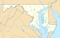
| Location | Allegany County, Maryland |
| Parent range | Ridge-and-Valley Appalachians |
| Topo map | USGS Oldtown |
Warrior Mountain is a cool natural feature located in Allegany County, Maryland. It's not a single peak, but rather a long, narrow stretch of high ground called a ridge. This ridge is part of the larger Ridge-and-Valley Appalachians mountain range.
Exploring Warrior Mountain
Warrior Mountain starts about 3 miles (4.8 km) northwest of a town called Oldtown, Maryland. From there, it stretches northeastward. Imagine a long, wavy line on a map – that's how this ridge looks!
Where the Ridge Ends and Begins
The ridge continues until it reaches a special spot called a water gap. This gap was carved out by the Murley Branch of Town Creek. This creek is a tributary of the famous Potomac River. The water gap is located about 1.25 miles (2.01 km) south of Flintstone, Maryland.
Warrior Ridge and Its Neighbors
North of this water gap, the ridge changes its name slightly to Warrior Ridge. This part of the ridge runs right next to another mountain called Tussey Mountain. They run parallel to each other, like two long lines on a map. Warrior Ridge continues north past Everett, Pennsylvania. Eventually, its high line joins up with the ridge line of Tussey Mountain. This meeting point is near the border between Blair County and Bedford County in Pennsylvania.
 | Claudette Colvin |
 | Myrlie Evers-Williams |
 | Alberta Odell Jones |


