
Weabonga, New South Wales facts for kids
Quick facts for kids WeabongaNew South Wales |
|
|---|---|
 |
|

Weabonga
Location in New South Wales
|
|
| Population | 49 (2006 census) |
| Postcode(s) | 2340 |
| Elevation | 734 m (2,408 ft) |
| Location | |
| LGA(s) | Tamworth Regional Council |
| County | Parry |
| Parish | Loftus |
| State electorate(s) | Tamworth, Northern Tablelands |
| Federal Division(s) | New England |
Weabonga is a small village in Australia. It's located next to Swamp Oak Creek. This village is about 37 kilometers southwest of Walcha. It's also about 33 kilometers south-southeast of Limbri, New South Wales.
Weabonga is nestled in the hills of the Great Dividing Range. It is part of the Tamworth Regional Council area. The winding road to Weabonga follows Swamp Oak Creek. This creek eventually joins the Cockburn River.
The village sits about 749 meters above sea level. It has a mild climate. The area gets about 750 to 850 millimeters of rain each year. The land around Weabonga has open valleys and steep hills. You might see some old, unused mines there. Many native trees grow here, like native apples, box trees (Eucalyptus melliodora), gums, and ironbark.
Contents
The History of Weabonga Village
The land where Weabonga is today was traditionally home to the Kamilaroi people. The name Weabonga means "swampgum." Before that, it was called Rywung, which meant "resting place," or sometimes Swamp Oak.
Around 1848, a man named Peter Brodie had permission to use a large area of land called Swamp Oak Creek. This land was about 207 square kilometers. It could support about 1,000 cattle and 8,000 sheep. Later, the permission for this land went to John Gill. The main farm building for Swamp Oak Creek was where Limbri is now. Other smaller stations were used to manage the sheep. The natural hills and valleys made this area good for raising sheep. It also provided shelter for young lambs.
Gold Mining in Weabonga
Some gold was found in the Mulla Creek and Rywung (now Weabonga) areas in the early 1850s. In 1890, a newspaper reported that about 25 men were looking for gold. They were working on Swamp Oak and Mulla Creeks. The main gold areas were called the Alpine, Rainbow, and Storm King reefs. By January 1891, 400 to 500 people were working here. About 50 mine shafts were dug into the ground.
In December 1890, Swamp Oak Creek Station sheared 20,000 sheep. They produced high-quality wool. In January 1891, more miners and their families moved to the gold areas. They went further up the creek to Top Station and Bungendore. Because of all the mining, the farm animals had to be moved away from the region.

Swamp Oak, also known as Rywung, officially became a town on January 24, 1891. By the end of January, the town had three stores, two butcher shops, a bakery, and a blacksmith. There were also several boarding houses. The next month, a post office opened, and mail service began.
In 1891, a count showed that the town had 130 homes. There were 188 men and 24 women living there. A police station and a local court were set up in Swamp Oak in 1891. The Rywung public school was finished in December 1891. In 1892, a slaughter yard was built to provide meat for the miners. By 1897, thirty-nine crushing plants were working at Swamp Oak.
Most of the gold mining here involved digging into quartz rock. Miners would drill holes in the mine walls and ceiling. They used a steel rod and a sledgehammer. Then, they would pack the holes with gunpowder. They lit long fuses and got to a safe distance. After the rock was blasted, miners would lift it to the surface. They used a hand-operated windlass. Then, the rock went into a crusher to get the gold out. Gold was mined here until at least 1922. It was very hard work, often for little reward. Manganese and rhodonite were also mined in large amounts in the Weabonga area.
Community Life and Changes
In 1912, the Weabonga Church of England was built. It was named St George's. From 1914 to 1929, the NSW Bush Nursing Association had a branch in Swamp Oak. They provided a trained nurse to help people. A public hall was built in 1916. Money for it was raised during World War I. In 1917, the town's name changed from Swamp Oak to Weabonga.
In 1928, there were 120 voters in Weabonga and the surrounding area. A timber Catholic Church was built in 1929. The police station closed in 1944. Now, police services come from Walcha Road. In 1966, electricity came to eight homes in Weabonga. The Weabonga (formerly Rywung) State School closed in 1968. This happened because fewer people lived in the area.
In November 2008, severe floods hit Mulla Creek and Weabonga. The road from Limbri to Weabonga was cut off. Two bridges were damaged and had to be bypassed. The Sherrin Bridge on this road was very badly damaged.
Sports and Recreation in Weabonga
Tennis courts were built in 1893 for local players. Two public courts were also made in the 1920s. However, they are no longer in good condition.
Cricket teams from Weabonga played against other villages starting in 1891. A jockey club was formed in Swamp Oak in January 1893. Horse races were held at several places in the region.
The village has the Weabonga Hall and Recreation Ground Committee. This group takes care of the hall and recreation area. The Weabonga Rural Fire Service helps protect the area from fires.
Today, Weabonga is mainly a farming village. Raising sheep and cattle are the main activities.
Images for kids
-
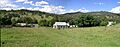
Weabonga village
