Weatogue, Connecticut facts for kids
Quick facts for kids
Weatogue, Connecticut
|
|
|---|---|

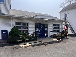
Weatogue Post Office
|
|
| Country | United States |
| State | Connecticut |
| County | Hartford |
| Town | Simsbury |
| Area | |
| • Total | 3.02 sq mi (7.81 km2) |
| • Land | 3.00 sq mi (7.76 km2) |
| • Water | 0.02 sq mi (0.05 km2) |
| Elevation | 300 ft (90 m) |
| Population
(2010)
|
|
| • Total | 2,776 |
| • Density | 926/sq mi (357.7/km2) |
| Time zone | UTC-5 (Eastern) |
| • Summer (DST) | UTC-4 (Eastern) |
| ZIP code |
06089
|
| Area code(s) | 860 |
| FIPS code | 09-80770 |
| GNIS feature ID | 2377877 |
Weatogue is a village and a special kind of community called a census-designated place (CDP) in Simsbury, Hartford County, Connecticut. In 2010, about 2,776 people lived there. A CDP is an area that looks like a town but isn't officially incorporated as one. It's used by the United States Census Bureau for gathering population data.
Contents
Exploring Weatogue's Location
Weatogue is located in the southern part of the larger town of Simsbury. It shares borders with other areas like West Simsbury to the northwest and Simsbury Center to the northeast.
Natural Borders and Waterways
The northern edge of Weatogue follows roads like Town Forest Road and Stratton Brook Road. It also includes a small part of U.S. Route 202 and a stream called Second Brook, which flows into the Farmington River. The eastern border of Weatogue runs along the Farmington River as it flows south. Another stream, Minister Brook, forms part of the southern boundary.
Roads and Key Areas
Other roads that help define Weatogue's borders include Pine Glen Road, Park Road, Orchard Lane, and Overlook Terrace. The original settlement area of Weatogue is found in the eastern part of the CDP. This historic spot is where US 202 (also known as Hopmeadow Street) meets Canal Street and Stratton Brook Road.
Size and Land Use
According to the United States Census Bureau, Weatogue covers a total area of about 7.81 square kilometers (which is about 3.02 square miles). Most of this area, about 7.76 square kilometers (3.00 square miles), is land. Only a small part, about 0.05 square kilometers (0.02 square miles), is water, making up less than 1% of its total area.
Who Lives in Weatogue?
The census helps us understand the people who live in Weatogue. In the year 2000, there were 2,805 people living in the area. These people lived in 1,007 households, and 815 of these were families.
Families and Households
Many households in Weatogue were families. About 44.8% of households had children under 18 living with them. Most families, 73.1%, were married couples living together. Some households, 16.1%, were made up of people living alone. About 4.8% of households had someone aged 65 or older living by themselves. On average, there were about 2.79 people in each household and 3.15 people in each family.
Age Groups in the Community
The population of Weatogue includes people of all ages. In 2000:
- About 30.3% of the people were under 18 years old.
- About 3.5% were between 18 and 24 years old.
- About 29.1% were between 25 and 44 years old.
- About 26.8% were between 45 and 64 years old.
- About 10.3% were 65 years old or older.
The median age in Weatogue was 39 years. This means half the people were younger than 39 and half were older. For every 100 females, there were about 96.8 males.
See also
 In Spanish: Weatogue para niños
 | Sharif Bey |
 | Hale Woodruff |
 | Richmond Barthé |
 | Purvis Young |


