
Simsbury Center, Connecticut facts for kids
Quick facts for kids
Simsbury Center, Connecticut
|
|
|---|---|

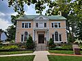
Simsbury Free Library
|
|

Simsbury Center, Connecticut
Location in Connecticut

Simsbury Center, Connecticut
Location in the United States
|
|
| Country | United States |
| State | Connecticut |
| County | Hartford |
| Town | Simsbury |
| Area | |
| • Total | 4.6 sq mi (11.8 km2) |
| • Land | 4.6 sq mi (11.8 km2) |
| • Water | 0 sq mi (0 km2) |
| Elevation | 185 ft (56 m) |
| Population
(2010)
|
|
| • Total | 5,836 |
| • Density | 1,281/sq mi (494.6/km2) |
| Time zone | UTC-5 (Eastern) |
| • Summer (DST) | UTC-4 (Eastern) |
| ZIP code |
06070 (Simsbury)
|
| Area code(s) | 860 |
| FIPS code | 09-69010 |
| GNIS feature ID | 2377861 |
Simsbury Center is a special area in the town of Simsbury, Connecticut, United States. It's called a census-designated place (CDP) because the U.S. government uses it for counting people. It includes the main part of Simsbury and the neighborhoods right around it.
In 2010, about 5,836 people lived in Simsbury Center. The oldest part of this area is known as the Simsbury Center Historic District. It's even listed on the National Register of Historic Places because of its important history.
Contents
Exploring Simsbury Center's Location
Simsbury Center is surrounded by different roads and natural features. To the north, you'll find Hoskins Road. To the east, there's an old railroad path, which is now partly a bike trail. Stratton Brook Road is to the south, and to the west, you'll see Bushy Hill Road, Hop Brook, Grimes Brook, Great Pond Road, and Laurel Lane.
Neighboring Communities
Simsbury Center shares its western border with West Simsbury. To the south, it's next to Weatogue. The Farmington River flows north just east of Simsbury Center.
Main Roads and Travel
The main road that goes through Simsbury Center is a combination of U.S. Route 202 and Connecticut Route 10. This road goes north towards Granby and south towards Avon.
Another important road is Connecticut Route 309, also called West Street. It leads west from Simsbury Center through West Simsbury to North Canton. Connecticut Route 167 (Bushy Hill Road) branches off Route 309 and goes southwest to Crowleys Corner. This spot is right on the border between Simsbury and Avon.
Simsbury Center is about 11 miles (18 km) northwest of Hartford. It's also about 23 miles (37 km) southwest of Springfield, Massachusetts.
Area Size
The total area of Simsbury Center is about 4.5 square miles (11.8 square kilometers). Almost all of this area is land, with only a very small part (about 0.10%) being water.
Who Lives in Simsbury Center?
In 2000, there were 5,603 people living in Simsbury Center. These people lived in 2,216 homes, and 1,582 of these were families.
Population Details
The people living in Simsbury Center are of different ages:
- About 27.3% were under 18 years old.
- About 3.7% were between 18 and 24 years old.
- About 28.6% were between 25 and 44 years old.
- About 25.7% were between 45 and 64 years old.
- About 14.6% were 65 years old or older.
The average age of people in Simsbury Center was 40 years.
Images for kids
-
Simsbury Free Library
See also
 In Spanish: Simsbury Center para niños
