
Wekiva River facts for kids
Quick facts for kids Wekiva River |
|
|---|---|

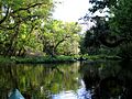
Canoeing on the Wekiva River
|
|


Location of the mouth in Florida
|
|
| Other name(s) | Wekiwa |
| Country | United States |
| State | Florida |
| Counties | Orange, Lake, Seminole |
| Physical characteristics | |
| Main source | Wekiwa Springs Apopka, Florida 70 ft (21 m) 28°42′42.80″N 81°27′37.5″W / 28.7118889°N 81.460417°W |
| River mouth | DeBary, Florida 30 ft (9.1 m) 28°52′39.2″N 81°22′1.3″W / 28.877556°N 81.367028°W |
| Length | 16.0 mi (25.7 km) |
| Basin features | |
| River system | St. Johns River |
| Basin size | 351.113 sq mi (909.38 km2) |
| Tributaries |
|
| Progression : Wekiva River-St. Johns River-Atlantic Ocean | |
| Type: | Wild, Scenic, Recreational |
| Designated: | October 13, 2000 |
The Wekiva River (sometimes spelled Wekiwa) is a 16.0-mile-long (25.7 km) river in Central Florida, north of Orlando. The word "Wekiwa" comes from the Muscogee language, spoken by Native American tribes like the Creek and Seminole. It means "spring of water."
The Wekiva River starts in Apopka and flows until it joins the St. Johns River, which is the longest river in Florida. The Wekiva River system includes its main stream, three important smaller rivers (called tributaries) – Rock Springs Run, Blackwater Creek, and the Little Wekiva River – and about 30 underground springs that add water to it.
This river is very special! It's recognized as a Florida State Canoe Trail, meaning it's great for canoeing. It's also an Outstanding Florida Water and an Aquatic Preserve because of its natural beauty and importance. The Wekiva River is one of only two rivers in Florida that is a National Wild and Scenic River. This special title is given by the U.S. government to protect its amazing scenery, fun recreation, unique geology, and diverse animal habitats.
Even though some people think "Wekiva" means "flowing water," the name "Wekiwa" actually means "spring." The different spelling came from early mapmakers and developers. Maps from the 1800s often spelled it "Wekiwa."
Contents
About the Wekiva River
The Wekiva River system flows through three counties in Florida: Orange, Seminole, and Lake. Its total drainage basin (the area of land where all the water drains into the river) is about 351.113 km2 (135.565 sq mi). The Wekiva River mostly forms the border between Orange and Seminole Counties. Further along, it separates Lake County and Seminole County.
Where the River Begins

The Wekiva River officially starts at Wekiwa Springs. About 3⁄4 mile (1.2 km) from this spring, another stream called Rock Springs Run joins the Wekiva.
The part of the river from Wekiwa Springs to where Rock Springs Run joins it is sometimes called Wekiwa Springs Run. After these two streams meet, the main Wekiva River flows for about 15.3 miles (24.6 km) until it reaches the St. Johns River. Other springs, like Sanlando Springs and Palm Springs, also add water to the Wekiva River system.
The River's Journey
Wekiwa Springs
The very start of the Wekiva River is at Wekiwa Springs. This is a large spring located inside Wekiwa Springs State Park in Apopka. The spring releases a lot of water every day, flowing from two openings deep underwater.
A short distance from the springs, a small wall (called a weir) creates a large, calm pool perfect for swimming. The clear, bluish-green water then narrows into a 60-foot (18 m)-wide stream as it flows towards the northeast.
Rock Springs Run
After flowing for only about 3⁄4 mile (1.2 km), the Wekiva River meets Rock Springs Run. This stream also comes from a spring called Rock Springs, which is about 4 miles (6.4 km) northwest of Wekiwa Springs. Rock Springs is located inside Kelly Park, a park in Apopka.
After leaving Kelly Park, Rock Springs Run winds through the Wekiwa Springs State Park for about 9.2 miles (14.8 km) before joining the Wekiva River. After they meet, the land to the left of the Wekiva River is protected by the Rock Springs Run State Reserve, another Florida state park.

Sweetwater Creek
The Wekiva River is joined by Sweetwater Creek from Seminole County. This happens about 1.2 mi (1.9 km) from where the Wekiva River starts. Sweetwater Creek is about 2-mile (3.2 km)-long and gets water from Miami Springs before it flows into the Wekiva River.
Wekiva River Buffer Conservation Area
Along the eastern side of the river, there's a protected area called the Wekiva River Buffer Conservation Area. This huge area, about 2,570 acres (1,040 ha), is made up of beautiful wetlands and floodplain forests. It's filled with different kinds of trees, ferns, and sabal palms. Protecting this natural area helps keep the water clean in both the Wekiva and Little Wekiva Rivers.
Little Wekiva River
The Little Wekiva River flows into the Wekiva River about 4.7 mi (7.6 km) from the Wekiva's source. This 15-mile (24 km)-long river is important because it collects water from areas north and west of the city of Orlando.
Many groups, including the St. Johns River Water Management District and the Florida Department of Environmental Protection, are working together to protect and improve the Little Wekiva River. Their goal is to make sure it doesn't negatively affect the water quality of the main Wekiva River. In Longwood, before the Little Wekiva enters the Wekiva River Buffer Conservation Area, several springs, including Sanlando Springs, add fresh underground water to it.
State Road 46 Bridge
The State Road 46 bridge is the only active road bridge that crosses the Wekiva River. It's located about 9 miles (14 km) from Wekiwa Springs State Park.
Blackwater Creek
The last major tributary to join the Wekiva River is the 19-mile (31 km) Blackwater Creek. It flows into the Wekiva about 2 miles (3.2 km) before the Wekiva River joins the St. Johns River.
Images for kids
-
Canoeing on the Wekiva River
