Northern Sunrise County facts for kids
Quick facts for kids
Northern Sunrise County
|
||
|---|---|---|
|
||

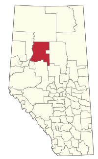
Location within Alberta
|
||
| Country | Canada | |
| Province | Alberta | |
| Region | Northern Alberta | |
| Census division | 17 | |
| Established | 1994 | |
| Incorporated | 2002 | |
| Area
(2021)
|
||
| • Land | 20,915.18 km2 (8,075.40 sq mi) | |
| Population
(2021)
|
||
| • Total | 1,711 | |
| • Density | 0.1/km2 (0.3/sq mi) | |
| Time zone | UTC−7 (MST) | |
| • Summer (DST) | UTC−6 (MDT) | |
Northern Sunrise County is a special type of local government area called a municipal district. It is located in northern Alberta, Canada. Think of it like a big county that includes smaller towns and communities.
Its main office is found just east of the town of Peace River. This office is where the local government works to serve the people living in the county.
Contents
History of Northern Sunrise County
This area has not always been called Northern Sunrise County. Before July 10, 2002, it was known by a different name: the Municipal District of East Peace No. 131. The change to Northern Sunrise County marked a new chapter for the region.
Geography and Communities
Northern Sunrise County covers a very large area. Within its borders, you'll find different kinds of communities. These range from small villages to even smaller hamlets and other named places called localities.
Urban Communities in the County
Even though Northern Sunrise County is a large rural area, it surrounds one small urban community. This community is a village.
Hamlets within the County
Hamlets are smaller communities than villages. They are important parts of Northern Sunrise County.
Localities in the County
Localities are simply named places within the county. They might not have many buildings or people, but they are recognized areas.
- Atikamisis Lake Settlement
- Bison Lake
- Cardinal Point
- Harmon Valley
- Judah
- L'Hirondelle
- Lubicon Lake
- Marten River
- Martin River
- Martin River Subdivision
- Simon Lakes
- Springburn
- Three Creeks
- Wabasca Settlement
- Wabiskaw Settlement
- Wesley Creek
Population of Northern Sunrise County
Understanding the population helps us know how many people live in an area. This information comes from a count called a census.
2021 Population Count
In 2021, Statistics Canada counted the population of Northern Sunrise County. There were 1,711 people living there. These people lived in 658 homes.
The total area of the county is about 20,915 square kilometers. This means the population density was very low, with only about 0.1 people per square kilometer. This shows it's a very spread-out area.
Population Changes Over Time
The population of Northern Sunrise County has changed a bit over the years.
- In 2016, the population was 1,891 people.
- This means the population decreased slightly between 2016 and 2021.
Local governments also sometimes do their own counts. In 2013, a local census counted 1,933 people. They also counted an extra 592 non-permanent people, like workers, bringing the total to 2,525 at that time.

