West Mifflin, Pennsylvania facts for kids
Quick facts for kids
West Mifflin, Pennsylvania
|
|
|---|---|
|
Borough
|
|

|
|

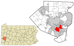
Location in Allegheny County and the U.S. state of Pennsylvania.
|
|
| Country | |
| State | |
| County | Allegheny |
| Incorporated | 1788 (Mifflin Township) |
| Dec. 11, 1942 (Borough) | |
| Area | |
| • Total | 14.50 sq mi (37.56 km2) |
| • Land | 14.21 sq mi (36.79 km2) |
| • Water | 0.29 sq mi (0.76 km2) 1.8% |
| Population
(2020)
|
|
| • Total | 19,589 |
| • Estimate
(2019)
|
19,699 |
| • Density | 1,386.67/sq mi (535.38/km2) |
| Time zone | UTC-5 (EST) |
| • Summer (DST) | UTC-4 (EDT) |
| ZIP code |
15122
|
| Area code(s) | 878 |
| FIPS code | 42-83512 |
West Mifflin is a town, called a borough, in Allegheny County, Pennsylvania, United States. It is located southeast of downtown Pittsburgh. In 2020, about 19,589 people lived there. The borough is named after Thomas Mifflin. He was the first Governor of Pennsylvania and helped sign the United States Constitution.
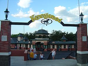
West Mifflin is mostly a place where people live. But it also has Kennywood Park, which is one of America's oldest amusement parks. Other important places that provide jobs include:
- Bettis Atomic Power Laboratory: This is a research center for advanced naval nuclear power.
- Bombardier: A company that makes monorails.
- US Steel's Mon Valley Works–Irvin Plant: A large steel plant.
- Community College of Allegheny County's South Campus: A college campus.
- Allegheny County Airport: A local airport.
Contents
About West Mifflin's Location
West Mifflin covers about 14.4 square miles (37 km2). Most of this area is land (14.2 square miles (37 km2)), and a small part is water (0.3 square miles (0.78 km2)). The land is mostly hilly and has many trees. The Monongahela River forms part of the borough's eastern border.
Neighboring Towns and Areas
West Mifflin shares its borders with ten other places:
- To the north: Pittsburgh neighborhoods like Lincoln Place and Hays, plus the towns of Munhall and Whitaker.
- To the east: Duquesne.
- To the southeast: Dravosburg.
- To the south: Jefferson Hills, Pleasant Hills, and a small part of Clairton.
- To the west: Baldwin.
Across the Monongahela River, West Mifflin is near:
Population of West Mifflin
| Historical population | |||
|---|---|---|---|
| Census | Pop. | %± | |
| 1940 | 8,694 | — | |
| 1950 | 17,985 | 106.9% | |
| 1960 | 27,289 | 51.7% | |
| 1970 | 28,070 | 2.9% | |
| 1980 | 26,322 | −6.2% | |
| 1990 | 23,644 | −10.2% | |
| 2000 | 22,464 | −5.0% | |
| 2010 | 20,313 | −9.6% | |
| 2020 | 19,589 | −3.6% | |
| 2019 (est.) | 19,699 | −3.0% | |
| Sources: | |||
In 2000, there were 22,464 people living in West Mifflin. There were 9,509 households and 6,475 families. The population density was about 1,586.2 inhabitants per square mile (612.4/km2), meaning that many people lived in each square mile.
Most people in West Mifflin were White (89.64%). About 8.85% were African American. A small number of people were Native American, Asian, or from other backgrounds.
The average household had 2.35 people, and the average family had 2.89 people. About 26.8% of households had children under 18.
The median age in West Mifflin was 42 years old. This means half the people were younger than 42 and half were older. About 21.5% of the population was under 18.
The median income for a household was $36,130. For families, it was $46,192. The average income per person was $18,140. About 10.2% of the people lived below the poverty line.
Environment and Nature
Mining for coal in the past has changed how small streams flow and the quality of their water. Land has also been changed by filling in valleys to make more flat areas for building. Efforts are made to keep the environment clean and healthy. West Mifflin has its own facility to treat wastewater. The Environmental Protection Agency (EPA) checks many facilities to make sure they follow environmental rules.
Schools in West Mifflin
West Mifflin has seven schools: four public schools and three private schools. The public schools are part of the West Mifflin Area School District. Students from nearby Whitaker and Duquesne also attend schools in this district.
There are two elementary schools, one middle school, and one high school in West Mifflin. There are also 13 preschools.
| Name | Grade level | Address | Enrollment | Type |
|---|---|---|---|---|
| Calvary Baptist Preschool & Kindergarten | Day Care through K | 120 Anborn Drive | 7 | Private |
| Clara Barton Elementary School | K-3 | 764 Beverly Drive | 222 | Public |
| Cornerstone Christian Prepar Academy | Pre-K–12 | 1900 Clairton Road | 251 | Private |
| Homeville Elementary School | K-3 | 4315 Eliza Street | 395 | Public |
| Walnut Grove Christian School | Pre-K-6 | 44 Adams Avenue | 251 | Private |
| West Mifflin Middle School | 4–8 | 91 Commonwealth Avenue | 641 | Public |
| West Mifflin Area High School | 9–12 | 91 Commonwealth Avenue | 1162 | Public |
Some schools have closed over the years, like New England Elementary (2012), Saint Agnes School (2019), and New Emerson (2020). Wilson Christian Academy merged into Cornerstone Christian Preparatory Academy in 2016.
The Community College of Allegheny County also has its South Campus in West Mifflin.
Getting Around West Mifflin
West Mifflin is mainly reached by roads. There are no major Interstate highways that go directly through the area. The main road is Pennsylvania Route 885, which connects to Pennsylvania Route 51 nearby.
The Allegheny County Airport is located in West Mifflin. This airport is for general aviation, meaning it's used for private planes rather than large commercial flights. For commercial flights, the closest airports are Pittsburgh International Airport and Arnold Palmer Regional Airport.
See also
 In Spanish: West Mifflin para niños
 | May Edward Chinn |
 | Rebecca Cole |
 | Alexa Canady |
 | Dorothy Lavinia Brown |

