West Perrine, Florida facts for kids
Quick facts for kids
West Perrine, Florida
|
|
|---|---|

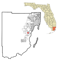
Location in Miami-Dade County and the state of Florida
|
|

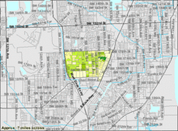
U.S. Census Bureau map showing CDP boundaries
|
|
| Country | |
| State | |
| County | |
| Area | |
| • Total | 1.75 sq mi (4.54 km2) |
| • Land | 1.75 sq mi (4.54 km2) |
| • Water | 0.00 sq mi (0.00 km2) |
| Elevation | 10 ft (3 m) |
| Population
(2020)
|
|
| • Total | 10,602 |
| • Density | 6,047.92/sq mi (2,334.53/km2) |
| Time zone | UTC-5 (Eastern (EST)) |
| • Summer (DST) | UTC-4 (EDT) |
| ZIP Code |
33157 (Miami)
|
| Area code(s) | 305, 786, 645 |
| FIPS code | 12-76700 |
| GNIS feature ID | 1853304 |
West Perrine is a special kind of community in Miami-Dade County, Florida, United States. It's called a census-designated place (CDP). This means it's an area that the government counts for population, but it doesn't have its own city government like a town or city. West Perrine is part of the larger Miami metropolitan area in South Florida. In 2020, about 10,602 people lived there, which was more than the 9,460 people counted in 2010.
History of West Perrine
Before the year 2000, West Perrine was part of a larger area simply called Perrine. Later, Perrine was split into two parts. One part became East Perrine, which is now part of the Village of Palmetto Bay.
West Perrine is still an "unincorporated area." This means it's not officially a city or town with its own mayor and city council. Instead, it's governed by Miami-Dade County. Some people who live there have talked about the idea of West Perrine becoming its own official town. The name "Perrine" comes from Henry Perrine, who was a scientist and farmer. He received a special land grant in the area a long time ago.
Where is West Perrine Located?
West Perrine is about 16 miles (26 km) southwest of downtown Miami. You can find it at these coordinates: 25°36′18″N 80°21′43″W / 25.60500°N 80.36194°W.
It has several neighbors:
- To the north is Palmetto Estates.
- To the east is Palmetto Bay.
- To the southeast is Cutler Bay.
- To the south is South Miami Heights.
- To the west is Zoo Miami.
The community covers a total area of about 1.8 square miles (4.7 km2), and all of it is land. There's no water area within its borders.
U.S. Route 1, also known as Dixie Highway, runs along the eastern edge of West Perrine. This major road goes northeast towards Miami and southwest towards Homestead, which is about 12 miles (19 km) away.
Population and People
| Historical population | |||
|---|---|---|---|
| Census | Pop. | %± | |
| 2000 | 8,600 | — | |
| 2010 | 9,460 | 10.0% | |
| 2020 | 10,602 | 12.1% | |
| U.S. Decennial Census | |||
West Perrine has been growing! In 2010, there were 9,460 people living there. By 2020, the population had increased to 10,602 people.
In 2020, there were 10,602 people living in West Perrine. These people lived in 2,774 households, and 2,131 of these were families. The community is home to a diverse mix of people from different backgrounds.
See also
 In Spanish: West Perrine para niños
 | Roy Wilkins |
 | John Lewis |
 | Linda Carol Brown |

