West Side Historic District (Saratoga Springs, New York) facts for kids
Quick facts for kids |
|
|
West Side Historic District
|
|

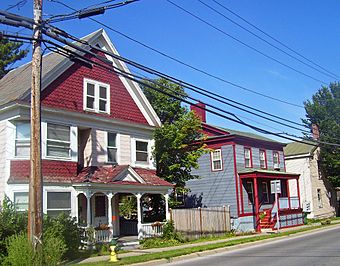
Houses on Washington Street,
south elevation and west profile, 2008 |
|
| Location | Saratoga Springs, New York |
|---|---|
| Area | 122 acres (49 ha) |
| Built | 19th and early 20th century |
| Architect | Various |
| Architectural style | Various period styles |
| NRHP reference No. | 94000258 |
| Added to NRHP | 1994 |
The West Side Historic District is a special neighborhood in Saratoga Springs, New York. It's located just west of the city's main downtown area. This district covers about 122 acres (49 ha) and includes streets like Church (which is NY 9N) and Washington (NY 29). It also includes the former Franklin Square Historic District.
This area is known for its many old houses from the 1800s. These homes are still in great shape and show the simple, everyday building styles of that time. The way the West Side grew was shaped by how the land was first divided. Later, the arrival of railroads also played a big part. During the late 1800s, when Saratoga Springs was a popular resort town, the West Side was home to the people who worked in the city. In 1994, this area was recognized as a historic district. It was added to the National Register of Historic Places, which is a list of important places in the United States. Two buildings within the district, a house and a cemetery, are also listed on their own.
Contents
Exploring the West Side's Location
In Saratoga Springs, the "West Side" usually means the area from Broadway to the city's western edge. It stretches between Greenfield Avenue in the north and West Circular Street in the south. This larger area includes places like Skidmore College and Saratoga Hospital. The historic district's boundaries are a bit more specific. They only include parts of this area where old, important buildings (mostly houses) are still standing.
West Side Historic District Boundaries
The district's eastern edge generally follows Woodlawn Avenue. It then turns west to avoid some newer buildings. The boundary continues south to Washington Street. At Franklin Square, it heads south along Grand Street. It includes some houses on the south side of Grand Street.
The boundary then goes up Birch Street and along the back of houses on Washington Street. It turns north at Marvin Alley and then west at Division Street. It continues to follow property lines, avoiding new buildings near Church and West Harrison streets. The boundary then goes along the back of houses on the south side of Church Street, almost to Myrtle Street.
After following Church back east, it goes up Seward, Pearl, and Van Dorn streets. It includes some houses on the west side of Skidmore College. Then it follows the back property lines down to Pine Alley. After a short section eastward, it includes all houses on Waterbury Street south of the college. It also includes a few houses on Lawrence Street just north of Waterbury. The boundary returns to Pine Alley in the middle of the block to the east. Finally, it follows property lines along the west of State Street to its northernmost point at Greenfield. From there, it follows Greenfield Street back to Woodlawn Avenue.
What Makes the West Side Special?
Inside these boundaries, there are 500 buildings that are considered important to the district's history. Most of these are wooden houses. Another 18 spots where old houses used to stand are also important. There are also 57 other buildings that are not considered historic.
Most of the houses are on narrow pieces of land. These lots are usually about 60 feet (18 m) wide and 100 feet (30 m) deep. This was a common size for building lots in the 1800s. Along Woodlawn Avenue, there are a few more city-like areas. Here, you can find a mix of shops and homes.
A Look Back: West Side's History
The West Side grew over time, first shaped by how the land was divided. Later, the arrival of the railroad created a clear social line. This made the West Side the neighborhood for working-class families. The city's time as a popular resort also affected the edges of the district.
Early Days: Land Division (1768–1813)
The West Side's story began in the late 1700s, during the colonial period. This was when a large land grant, called the Kayaderossera patent, was divided up. This land was first given to Robert Livingston and David Schuyler in 1708. But it couldn't be sold for 60 years because of a disagreement over the Native American land deed. When it was finally divided, Lot 12, where most of Saratoga Springs is today, went to the heirs of Rip Van Dam.
Van Dam's heirs sold parts of the land to Isaac Low, Jacob Walton, and Anthony Van Dam. Each of them got a piece of land that included High Rock Spring, which was very valuable. Isaac Low was a Loyalist during the American Revolution. His land was taken by the government and sold in 1779. These early land divisions helped decide where streets and lots would be in the city and the district.
Henry Walton, the son of Jacob Walton, built a large country home called Wood Lawn. It was located where Skidmore College is now. He bought more land and developed Flat Rock Spring for tourists. Soon, Gideon Putnam started developing Congress Spring to the south. Both men also bought land west of the springs and made lots available for sale. A map Walton made in 1813 was the first to show Church and New streets. It was also the first to show the name Van Dam Street.
Railroads and Resorts (1833–1907)
Henry Walton and Rockwell Putnam (Gideon's son) helped start the Saratoga and Schenectady Railroad. This train line opened in 1833. The tracks ran west of Broadway, along New Street, past a station at Division Street. They crossed Broadway at Van Dam. These tracks are no longer there, but they greatly shaped the district. The railroad gave the neighborhood a center and helped it grow. It also made the West Side known as the working-class part of town. The wealthy people tended to live on the East Side.
By the mid-1800s, all the land four blocks west of Broadway was built up. New neighborhoods were being created from farmland west of Franklin and Walworth streets. The train station at Division and Franklin created Franklin Square. This was the only fancy neighborhood on the West Side. It had large Greek Revival style homes. Just west of it was a poorer area, first home to Irish immigrants and later Italians. This area was called Dublin, and it still is today.
In 1879, Henry Hilton bought Woodlawn from Walton's heirs. He made it much bigger, adding about 600 acres (240 ha). This happened during Saratoga Springs' busiest years as a resort. It led to the building of fancy vacation homes in the northern part of the West Side, next to the estate. The city's population more than tripled between 1850 and 1880. Most of these new people settled on the West Side.
Saratoga Springs' peak resort years ended in 1907 when gambling became illegal. The casino became city property in 1911, and its land became Congress Park in 1915. Later in the 1900s, projects to improve the city tore down some older buildings where the railroad tracks used to be. Part of the Woodlawn property became a senior housing complex with tall buildings. Skidmore College moved into the northern part of the land in 1976.
The West Side Today
Like other historic districts in the city, the West Side's historic look is protected. The city's Design Review Commission helps with this. This group reviews any planned signs or changes to the outside of buildings in the historic districts.
West Side Architecture: Homes and Styles
The West Side is mostly a neighborhood of homes. You can see many different types of houses here. These styles show the social status of the person who built or first owned the home. Wood is the most common building material. This is because the Adirondack forests were close to Saratoga Springs. The buildings here show the common building styles found in that region.
The narrow lots also affected how the houses were built. They often ended up being much deeper than they were wide. Even some of the bungalows built later were placed so that the side of the roof faced the street. The main entrance was also on the side of the lot. In a few cases, two lots were combined to build a wider house.
- Townhouses: These are the fanciest homes. You can find them on Franklin Square, Church, Woodlawn, Clinton, and Van Dam streets. They are usually two stories tall. They show the most detail and decoration, sometimes using brick or stone. They often sit far back from the street and have a porch, sometimes wrapping around the side.
- Village Residences: Most of the homes in the district are "village residences." These were for the middle class families who lived here. They are usually one or two stories tall and on smaller lots. Their design is simpler. Most have a front-facing gable roof. Many have porches, but with less decoration than townhouses. In the 1900s, many were covered with modern materials like vinyl or aluminum.
- Workers' Cottages: These homes were even smaller and plainer than village residences. Most are one story tall. They have porches but almost no decoration. They often used cheaper siding instead of clapboard. You can find them in the areas with the smallest and most crowded lots. This includes the south side of Van Dam Street and the northern end of State Street.
- Two-Family Houses: These were homes built or changed to house an owner and a tenant. They are similar to village residences. Some built around 1900 were designed to look like two row houses joined together. They are usually two stories tall and take up most of their larger lots, leaving little yard space.
- Tenements: These were larger, three-story buildings with flat roofs. They held more than two families and were usually owned by someone who didn't live there. Most are on back streets, like Russell or Waterbury streets, and are not decorated. A slightly more stylish example from later on is at 190–94 Grand Street.
- Outbuildings: Some houses had extra buildings that are also considered historic. Most were stables or carriage houses that were later turned into garages. These were usually simple sheds for a horse and wagon. A few later ones were built for cars. These buildings helped create the alleys in the middle of blocks, which later became streets.
Important Historic Buildings
The West Side Historic District was actually created after a smaller district. Two properties within that smaller district were later listed on the National Register on their own. Here are some other notable places in the current district:
- Franklin Square: This area was added to the National Register in 1972. It was the city's first historic district. It has 87 properties on 30 acres (120,000 m2). Most are fancy homes and outbuildings from the mid-1800s. They were built to be close to the new railroad station.
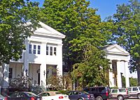
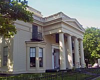
- Hiram Charles Todd House, 4 Franklin Square: This beautiful Greek Revival style house was likely built around 1837. It was one of the first buildings in Saratoga Springs to be listed on the National Register. It's named after Hiram Charles Todd, a famous lawyer who lived there in the early 1900s.
- Holmes Block, 102–08 Woodlawn Avenue: This group of four rowhouses was built after the American Civil War. They are in the Second Empire style, with special mansard roofs and dormer windows. They still have their original marble floors at the entrances.
- Tenement at 190–94 Grand Avenue: This building, built in 1896, has three attached two-unit homes. It was designed by R. Newton Brezee, who was known for his grand houses elsewhere in town. This tenement has more decoration than others in the district, like fancy brackets under the roof.


