West Yarmouth, Massachusetts facts for kids
Quick facts for kids
West Yarmouth, Massachusetts
|
|
|---|---|

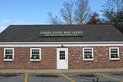
West Yarmouth Post Office
|
|

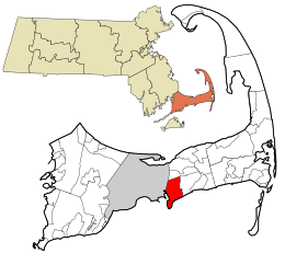
Location in Barnstable County and the state of Massachusetts.
|
|
| Country | United States |
| State | Massachusetts |
| County | Barnstable |
| Town | Yarmouth |
| Area | |
| • Total | 9.09 sq mi (23.55 km2) |
| • Land | 6.69 sq mi (17.33 km2) |
| • Water | 2.40 sq mi (6.23 km2) |
| Elevation | 20 ft (6 m) |
| Population
(2020)
|
|
| • Total | 6,278 |
| • Density | 938.56/sq mi (362.36/km2) |
| Time zone | UTC-5 (Eastern (EST)) |
| • Summer (DST) | UTC-4 (EDT) |
| ZIP code |
02673
|
| Area code(s) | 508/774 |
| FIPS code | 25-78795 |
| GNIS feature ID | 0615890 |
West Yarmouth is a community located in the town of Yarmouth, which is in Barnstable County, Massachusetts, United States. It's known as a census-designated place (CDP), which means it's a special area defined for counting people. In 2020, about 6,278 people lived there.
Contents
Exploring West Yarmouth's Location
West Yarmouth is found in the southwestern part of the town of Yarmouth. Its exact location is at 41.649547 degrees north and 70.246385 degrees west.
Nearby Towns and Waterways
- To the east, you'll find South Yarmouth.
- To the west, it borders Hyannis, which is part of the town of Barnstable.
- To the south, West Yarmouth meets the waters of Nantucket Sound.
- To the north, it's separated from Yarmouth Port by U.S. Route 6, also called the Mid-Cape Highway.
Size and Water Features
The United States Census Bureau says that West Yarmouth covers a total area of about 9.1 square miles (23.6 square kilometers). A good portion of this area, about 2.4 square miles (6.3 square kilometers), is water. This means water makes up about 26.54% of the area.
Who Lives in West Yarmouth?
The number of people living in West Yarmouth has changed over the years.
| Historical population | |||
|---|---|---|---|
| Census | Pop. | %± | |
| 2020 | 6,278 | — | |
| U.S. Decennial Census | |||
Community Members and Households
According to the census in 2000, there were 6,460 people living in West Yarmouth. These people lived in 2,911 households. A household is a group of people living together in one home. Out of these, 1,679 were families.
- The population density was about 963 people per square mile (371.7 people per square kilometer).
- There were 4,929 housing units, like houses or apartments.
Age Groups in the Community
The people in West Yarmouth are of different ages:
- About 17.7% of the population was under 18 years old.
- Around 6.0% were between 18 and 24 years old.
- About 27.1% were between 25 and 44 years old.
- Around 25.3% were between 45 and 64 years old.
- About 23.9% were 65 years old or older.
The average age of people in West Yarmouth was 44 years.
See also
 In Spanish: West Yarmouth para niños
 | Stephanie Wilson |
 | Charles Bolden |
 | Ronald McNair |
 | Frederick D. Gregory |

