
Westwood, Queensland facts for kids
Quick facts for kids WestwoodQueensland |
|||||||||||||||
|---|---|---|---|---|---|---|---|---|---|---|---|---|---|---|---|

Westwood Hotel, 2022
|
|||||||||||||||

Westwood
Location in Queensland
|
|||||||||||||||
| Population | 199 (2021 census) | ||||||||||||||
| • Density | 0.4466/km2 (1.157/sq mi) | ||||||||||||||
| Postcode(s) | 4702 | ||||||||||||||
| Area | 445.6 km2 (172.0 sq mi) | ||||||||||||||
| Time zone | AEST (UTC+10:00) | ||||||||||||||
| Location |
|
||||||||||||||
| LGA(s) |
|
||||||||||||||
| State electorate(s) | Fitzroy | ||||||||||||||
| Federal Division(s) | Flynn | ||||||||||||||
|
|||||||||||||||
Westwood is a small town in Queensland, Australia. It is special because it was the very first town officially declared by the new Queensland Government back in 1860. Today, Westwood is split between two local government areas: the Rockhampton Region and the Shire of Banana. In 2021, about 199 people lived in Westwood.
Contents
Where is Westwood Located?
Westwood is about 50 kilometers (31 miles) southwest of the city of Rockhampton. The northern part of Westwood is in the Rockhampton Region, while the southern part is in the Shire of Banana.
The town itself has a few houses, a hotel, and a police station. There are also two other small areas nearby:
- Huxham: This area is named after its railway station. The station got its name in 1919 from John Saunders Huxham, who was a government minister in Queensland.
- Spring Creek: Another small neighborhood in the area.
Roads and Railways in Westwood
The main road, the Capricorn Highway, goes right through Westwood. A few kilometers southwest of town, it meets another important road, the Leichhardt Highway.
The Blackwater railway line also runs through Westwood. It comes from the north and continues southwest, connecting the town to other places by train. Most of the land around Westwood is used for grazing animals on natural grasslands.
The History of Westwood
Westwood has an interesting past, being the first town officially declared by the Queensland Government.
How Westwood Got Its Name
Before Queensland became its own state, towns like Brisbane and Rockhampton were already official. But on May 23, 1860, Westwood became the first town to be "gazetted" (officially recognized) by the new Queensland Government. Even though the original plan called the area "Prestone," the Governor of Queensland, George Bowen, decided to name it Westwood. He chose this name after Westwood House, which was the home of Sir John Pakington, a British government official.
The Railway Arrives
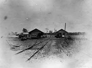
On September 29, 1867, the first part of the Great Northern Railway (now called the Central Western Line) reached Westwood from Rockhampton. This made Westwood an important "railhead," meaning it was the end of the railway line for a while. The first load of wool was sent by train from Westwood on August 23 that year.
Westwood was only meant to be the railhead for a short time. However, due to government paperwork and money problems, the next part of the railway line wasn't built until 1873. When the railway line moved further west, Westwood became less important as a rail hub.
Schools and Churches
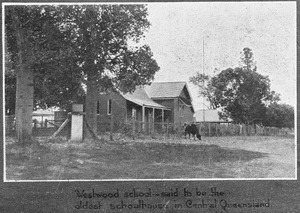
Westwood State School opened its doors on August 26, 1872, providing education for local children. A Protestant church also opened in Westwood on October 2, 1873, serving the community.
The Westwood Sanatorium
On September 6, 1919, a special hospital called the Westwood Sanatorium was opened. It had 64 beds and was built to help miners who had a lung disease called "miner's phthisis," caused by dusty working conditions. Later, it also treated people with Tuberculosis.
In 1953, a new road was built to the sanatorium and named Haigh Drive. It was named after Leonard Garfield Haigh, who was important to the Rockhampton Hospitals Board. The sanatorium closed in 1959 because new medicines made it easier to treat tuberculosis. The building was then used as a nursing home until the 1980s. Some parts of the sanatorium buildings were moved or taken down, and one is now a private home in Emerald.
Remembering History: Anzac Day
In 1996, Westwood held its first Anzac Day ceremony at a new memorial. Anzac Day is a special day to remember soldiers who served their country. About 80 people attended the event, including local leaders.
Local Government Changes
Westwood used to be part of the Shire of Fitzroy. But in 2008, there were changes to local governments, and Westwood became part of the Rockhampton Region.
Population of Westwood
The number of people living in Westwood has changed over the years:
- In 2006, there were 253 people.
- In 2011, the population was 240 people.
- In 2016, it was 174 people.
- In 2021, the population increased to 199 people.
Historic Places to See
Westwood has one site listed as a heritage-protected place:
- The remains of the Adolphus William Copper Smelter. This is a historic site where copper was once processed.
Education in Westwood
Westwood State School is a government primary school for students from Prep to Year 6. It is located at 108 Herbert Street. In 2017, the school had 13 students, and in 2022, it had 20 students.
There are no high schools in Westwood. Students who want to go to secondary school usually travel to Rockhampton State High School in Wandal, Rockhampton, which is to the northeast.
Images for kids
-
Front and rear views of the new state sanitorium at Westwood, June 1919
