Wherstead facts for kids
Quick facts for kids Wherstead |
|
|---|---|
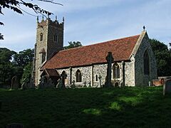
 St Mary's Church, Wherstead |
|
| Population | 342 (2011) |
| OS grid reference | TM157406 |
| District |
|
| Shire county | |
| Region | |
| Country | England |
| Sovereign state | United Kingdom |
| Post town | Ipswich |
| Postcode district | IP2, IP9 |
| EU Parliament | East of England |
| UK Parliament |
|
Wherstead is a small village and a civil parish in the county of Suffolk, England. It is located about 3 miles (5 km) south of Ipswich on the Shotley peninsula. Wherstead is part of the Suffolk County Council's electoral division called Belstead Brook.
Contents
A Look Back: Wherstead's History
Wherstead is a very old place. People have found signs that Romans and early Britons lived here long ago. In a very old book from 1086, called the Domesday Book, Wherstead was known by different names like Querstede and Wervesteda. Today, most people who live in Wherstead say its name as 'Wersted' or 'Warsted'.
The Paul Family's Connection to Wherstead
The Paul family, who were farmers and malt makers, bought land in Wherstead in 1934. George Paul, a member of this family, received an award called an MBE. He was well-known for his love of Suffolk Horses and horseracing. Today, his son and nephews run a local business called Suffolk Food Hall.
Important Buildings in Wherstead
Wherstead has several interesting buildings with long histories.
St Mary's Church: A Historic Place of Worship
The Church of St Mary, Wherstead, is an Anglican church. It stands on a hilltop where a church has been located since 1086. This church is now part of the Two Rivers Benefice, which includes churches in nearby villages like Stutton, Holbrook, Woolverstone, and Freston.
A vicar named Foster Barham Zincke wrote a book about Wherstead's history while he was in charge of St Mary's Church.
Bourne Bridge: A Village Boundary
Bourne Bridge marks the edge of Wherstead parish. Near this bridge, you'll find a pub that was once called The Ostrich Inn. Some people thought the name might have come from 'Oyster Ridge' because there used to be many oysters in the River Orwell nearby. However, it's more likely that the pub's name came from the family crest of Sir Edward Coke, a famous lawyer who owned land here in 1609. The pub was renamed The Oyster Reach in 1995. In 2017, it became part of the Beefeater restaurant chain.
Wherstead Park: A Grand Old House
Wherstead Park is a large, historic house. It was used as a place for events and gatherings for many years. However, it stopped being an events venue at the end of 2023.
 | Misty Copeland |
 | Raven Wilkinson |
 | Debra Austin |
 | Aesha Ash |


