Whitbarrow facts for kids
Quick facts for kids Whitbarrow |
|
|---|---|

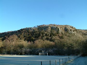
Whitbarrow from near Oversands School
|
|
| Highest point | |
| Elevation | 215 m (705 ft) |
| Prominence | 182 m (597 ft) |
| Parent peak | High Street |
| Listing | Marilyn, Outlying Wainwright |
| Geography | |
| OS grid | SD441870 |
| Topo map | OS Landranger 97 |
Whitbarrow is a beautiful hill in Cumbria, England. It's a very special place for nature. Because of its unique limestone areas, it's protected as a National Nature Reserve. It's also a Site of Special Scientific Interest, which means it's important for its plants, animals, and geology.
You might hear it called Whitbarrow Scar. This name usually refers to the tall cliffs on its western side. The hill is about 9 kilometers (5.6 miles) southwest of Kendal. It's also close to the village of Witherslack.
Contents
Discovering Whitbarrow Hill
Whitbarrow is a mix of different natural areas. You'll find thick woodland, open grassland, and unique limestone pavement. This "pavement" looks like a rocky, cracked surface.
How Whitbarrow Was Formed
The steep cliffs of Whitbarrow are made of limestone. This rock formed about 350 million years ago! That was during a time called the Carboniferous period. The main cliffs are made of rocks called Dalton Beds. Above these are Urswick Limestones. These are the rocks that formed the special limestone pavements you see.
Whitbarrow, like much of the Lake District, shows signs of the last ice age. When the ice melted, it left behind huge boulders called glacial erratics. The ice also scraped away soil, leaving bare limestone. Over time, rain and wind shaped this rock. This created the cracks (called grikes) and blocks (called clints) of the limestone pavement.
Protecting Whitbarrow's Limestone
Limestone from Whitbarrow was once used for building. It was also used to help grow crops and make millstones. But now, this special rock is protected by law. It is against the rules to remove any of it.
Whitbarrow National Nature Reserve is looked after by several groups. These include the Forestry Commission and the Lake District National Park Authority. The Cumbria Wildlife Trust also helps manage this amazing place.
Woodland and Wildlife
A large part of Whitbarrow is covered in trees. Some of these trees grew naturally. Others were planted starting in 1919. The Forestry Commission helps manage these woodlands. They use different methods, like cutting trees in a special way called coppicing. These different ways of managing the forest help many kinds of plants and animals live there.
Walking to Lord's Seat
The very top of Whitbarrow Scar is called Lord's Seat. A famous walker named Alfred Wainwright wrote about a walk to Lord's Seat. He described it in his book, The Outlying Fells of Lakeland.
Wainwright said this walk was "the most beautiful" in his book. He wrote that "All is fair to the eye on Whitbarrow." It sounds like a truly wonderful place to explore!
 | Janet Taylor Pickett |
 | Synthia Saint James |
 | Howardena Pindell |
 | Faith Ringgold |


