Widtsoe, Utah facts for kids
Quick facts for kids
Widtsoe, Utah
|
|
|---|---|

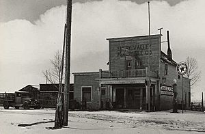
Emery Valley Mercantile Co. store in Widtsoe, 1936
|
|
| Country | United States |
| State | Utah |
| County | Garfield |
| Established | 1908 |
| Abandoned | 1936 |
| Named for | John A. Widtsoe |
| Elevation | 7,605 ft (2,318 m) |
| GNIS feature ID | 1447328 |
Widtsoe /ˈwɪtsoʊ/ is a ghost town in Garfield County, Utah, United States. It's found in John's Valley, which is northeast of Bryce Canyon. The town was built near the Sevier River and Sweetwater Creek. Widtsoe existed for about 28 years, from 1908 to 1936.
Contents
The Story of Widtsoe
Early Settlers and Ranch Life
The first people to settle in John's Valley arrived around 1876. Among them were Isaac Riddle and a wife of John D. Lee. Riddle's ranch became an important stop for the San Juan Expedition in 1879. For many years, the area was mostly used by local cattle ranchers. They would bring their animals to graze here during certain seasons. Not many people lived there permanently at first.
How the Town Got Its Name
In the early 1900s, a man named Jedediah Adair bought land in the valley. He started growing crops like oats, wheat, and barley. His farming success attracted other settlers. By 1908, the growing community was known as Adairville.
As more people moved in, the settlement grew even bigger. It was then renamed Houston after John Houston, who was a leader in the Church of Jesus Christ of Latter-day Saints in nearby Panguitch.
In 1910, Jedediah Adair's wife, Julia, gave 40 acres (0.16 km2) of land for an official townsite. The town was carefully planned with square blocks and wide streets. In 1912, the town got its own post office. Its name changed again to Winder, honoring a recently passed Latter-day Saint leader named John R. Winder.
Growth and Prosperity
Winder began to do very well. Sawmills were built in the canyon nearby. These mills provided wood for all the new buildings being constructed quickly. Besides houses, the town had a building that was both a church and a school. There were also two hotels, four stores, and a candy factory.
In 1917, the post office decided there were too many places in Utah named Winder. So, they asked for another name change. The town chose Widtsoe. This name honored John A. Widtsoe, who was the president of the University of Utah at the time. He was also a scientist who studied farming, especially dryland farming. His advice on farming in dry areas was very helpful to the local farmers.
Widtsoe continued to grow and became one of the main towns in Garfield County. In 1919, the United States Forest Service moved its local office from Panguitch to Widtsoe. People even talked about moving the county seat (the main government office for the county) to Widtsoe. By 1920, the town's population reached 1,100 people! Residents prepared for even more growth. They made nearby Pine Lake bigger and built a dam to get more irrigation water for their farms.
The Decline of Widtsoe
The town's good luck started to change in the summer of 1920. A serious drought (a long period with very little rain) threatened the crops. Luckily, rain finally came late in the season, helping the grain harvest. But the drought continued into the next year. Widtsoe's difficult weather began to make farmers leave.
In 1924, as the drought continued, a man named William F. Holt tried to help. He had been successful with irrigation in California's Imperial Valley. Holt set up a creamery (a place that makes dairy products) in John's Valley. He also built a storage pond and a flume (a channel) to bring water 7 miles (11 km) from Pine Lake. He invested a lot of money, but his efforts ultimately failed.
People noticed that John's Valley seemed to have a twenty-year cycle of drought followed by plenty of water. It looked like the drought period was just beginning. Soon, the only crop that could grow well was a special type of lettuce that grew at high altitudes.
In 1925, the Forest Service office moved away, and Widtsoe began to decline quickly. By 1930, the population had dropped to just 210 people. In 1935, only 17 families were left in town.
The End of the Town
In 1936, the federal Resettlement Administration stepped in. This government program bought land from local owners. The idea was to help people move to better farming areas and use the land for public grazing. However, the program was slow and not very efficient. It cost more to run the program than the money paid to buy the land. Deals that should have taken weeks ended up taking many months.
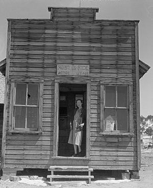
Finally, Widtsoe was emptied out. Government workers tore down most of the buildings. Over 26,000 acres (105 km2) of land were placed under the Taylor Grazing Act, which manages public grazing lands. A few houses and an old community building can still be seen at the site today.
Climate
The weather in Widtsoe has mild differences between its highest and lowest temperatures. It also gets enough rainfall throughout the year. According to the Köppen Climate Classification system, Widtsoe has a marine west coast climate. This type of climate is often shown as "Cfb" on climate maps.
 | Sharif Bey |
 | Hale Woodruff |
 | Richmond Barthé |
 | Purvis Young |


