Willowvale, Queensland facts for kids
Quick facts for kids WillowvaleQueensland |
|||||||||||||||
|---|---|---|---|---|---|---|---|---|---|---|---|---|---|---|---|

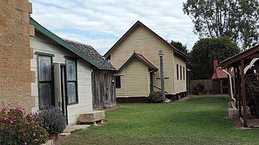
Willowvale Presbyterian church, now relocated to Pringle Cottage Museum, Warwick, 2015
|
|||||||||||||||
| Population | 108 (2021 census) | ||||||||||||||
| • Density | 2.283/km2 (5.91/sq mi) | ||||||||||||||
| Postcode(s) | 4370 | ||||||||||||||
| Area | 47.3 km2 (18.3 sq mi) | ||||||||||||||
| Time zone | AEST (UTC+10:00) | ||||||||||||||
| Location | |||||||||||||||
| LGA(s) | Southern Downs Region | ||||||||||||||
| State electorate(s) | Southern Downs | ||||||||||||||
| Federal Division(s) | Maranoa | ||||||||||||||
|
|||||||||||||||
Willowvale is a small rural area in the Southern Downs Region of Queensland, Australia. It is mostly made up of farms. In 2021, about 108 people lived in Willowvale.
Contents
What is Willowvale Like?
Willowvale is mostly farmland. You won't find big towns or cities here. It's a quiet place with lots of open space.
How Does Geography Shape Willowvale?
The Cunningham Highway runs along the eastern edge of Willowvale. This is a major road that connects different areas. A creek called Glengallan Creek flows through the northern part of Willowvale. There is also a hill named Mount Juliet in the southern part of the area.
What is the History of Willowvale?
Willowvale has a history connected to schools and churches. These buildings helped shape the community.
Early Schools in Willowvale
A school called Grayson Provisional School first opened in 1908. It became Grayson State School in 1909. A few years later, in 1912, its name changed to Willowvale State School. This school helped educate children in the area for many years. It closed its doors in 1967. The old school was located on Willowvale Road.
The Story of Willowvale's Church
The Grayson / Glengallan Presbyterian Church was built in 1909. It was across the road from the Grayson School. Local people helped build the church for free. William Skerman donated the land for it. By 1913, it was known as the Willowvale Presbyterian Church.
This church building moved twice! In the 1950s, it moved to Glennie Heights in Warwick. It became the Glennie Heights Presbyterian Church. Later, in 1972, it moved again to the Pringle Cottage Museum. There, it was renamed Eastwell Hall. This name honored Leslie Burt Eastwell, who was important to the local historical society.
Where Do Willowvale Kids Go to School?
Willowvale does not have its own schools today. Students living in Willowvale travel to nearby towns for their education.
Primary School Options for Willowvale Students
For primary school, kids can go to Glennie Heights State School in Warwick. Other options include Freestone State School in Freestone or Allora State School in Allora.
Secondary School Options for Willowvale Students
For high school, students can attend Warwick State High School in Warwick. This school goes up to Year 12. Allora State School also offers secondary education up to Year 10.
 | Madam C. J. Walker |
 | Janet Emerson Bashen |
 | Annie Turnbo Malone |
 | Maggie L. Walker |


