
Wolf Trap, Virginia facts for kids
Quick facts for kids
Wolf Trap, Virginia
|
|
|---|---|

Houses near the Barns at Wolf Trap
|
|

Location of Wolf Trap in Fairfax County, Virginia
|
|

Wolf Trap, Virginia
Location in Northern Virginia

Wolf Trap, Virginia
Location in Virginia

Wolf Trap, Virginia
Location in the United States
|
|
| Country | United States |
| State | Virginia |
| County | Fairfax |
| Area | |
| • Total | 9.8 sq mi (25.5 km2) |
| • Land | 9.8 sq mi (25.4 km2) |
| • Water | 0.04 sq mi (0.1 km2) |
| Elevation | 285 ft (87 m) |
| Population
(2020)
|
|
| • Total | 16,496 |
| • Density | 1,646/sq mi (635.6/km2) |
| Time zone | UTC−5 (Eastern (EST)) |
| • Summer (DST) | UTC−4 (EDT) |
| FIPS code | 51-87240 |
| GNIS feature ID | 1867602 |
Wolf Trap is a special area in Fairfax County, Virginia, in the United States. It's called a "census-designated place" (CDP). This means it's a community that the government counts for population, but it's not an official city or town.
In 2020, about 16,496 people lived in Wolf Trap. This area is also home to the famous Wolf Trap National Park for the Performing Arts.
Contents
Exploring Wolf Trap's Location
Wolf Trap is located in the northern part of Fairfax County. You can find it at these coordinates: 38°56′1″N 77°16′35″W / 38.93361°N 77.27639°W.
Neighboring Communities Around Wolf Trap
Wolf Trap has several neighbors. To the northeast, you'll find McLean. To the southeast is Tysons Corner. Vienna is to the south, and Oakton is to the southwest. If you go west, you'll reach Reston, and to the north is Great Falls.
Roads and Travel in Wolf Trap
The Dulles Toll Road goes right through the middle of Wolf Trap. You can get on or off it at Exits 15 (Wolftrap Park) and 16 (Virginia State Route 7). This toll road leads west about 11 miles to Washington Dulles International Airport. If you head east on the Toll Road and then Interstate 66, you can reach downtown Washington, D.C. in about 16 miles.
Virginia State Route 7 (also known as Leesburg Pike) forms the northern edge of Wolf Trap. This highway goes northwest about 20 miles to Leesburg.
Size of Wolf Trap's Area
According to the United States Census Bureau, the total area of Wolf Trap is about 25.5 square kilometers (9.8 square miles). Most of this area, about 25.4 square kilometers (9.8 square miles), is land. Only a small part, about 0.1 square kilometers (0.04 square miles), is water.
People Living in Wolf Trap
The number of people living in Wolf Trap has grown over the years.
| Historical population | |||
|---|---|---|---|
| Census | Pop. | %± | |
| 1980 | 9,875 | — | |
| 1990 | 13,133 | 33.0% | |
| 2000 | 14,001 | 6.6% | |
| 2010 | 16,131 | 15.2% | |
| 2020 | 16,496 | 2.3% | |
| source: | |||
Population Details and Diversity
In 2019, there were about 1,512 people living in every square mile of Wolf Trap. There were also about 4,606 homes.
The people living in Wolf Trap come from many different backgrounds:
- About 79% were White.
- About 2% were African American.
- About 14% were Asian.
- A small number were Native American or from other races, or from two or more races.
- About 2.63% of the population were Hispanic or Latino.
Households and Families in Wolf Trap
There were 5,462 households in Wolf Trap. A household means all the people living in one home.
- In 45.4% of these homes, there were children under 18 years old.
- Most homes (86.1%) had married couples living together.
- A small number (3.9%) had a female head of household with no husband present.
- About 8.6% were non-family households.
- About 6.3% of all households were made up of just one person.
- About 2.5% of homes had someone living alone who was 65 years old or older.
On average, about 3.07 people lived in each household, and about 3.19 people lived in each family.
Income in Wolf Trap
In 2019, the average income for a household in Wolf Trap was $222,908. This number is based on data from 2014 to 2018.
Images for kids
-
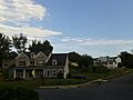
Houses near the Barns at Wolf Trap
-
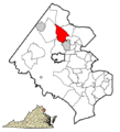
Location of Wolf Trap in Fairfax County, Virginia
See also
 In Spanish: Wolf Trap (Virginia) para niños
