
Great Falls, Virginia facts for kids
Quick facts for kids
Great Falls, Virginia
|
|
|---|---|

Location of Great Falls in Fairfax County, Virginia
|
|

Boundaries of the Great Falls CDP as of 2003
|
|

Great Falls, Virginia
Location in Northern Virginia

Great Falls, Virginia
Location in Virginia

Great Falls, Virginia
Location in the United States
|
|
| Country | United States |
| State | Virginia |
| County | Fairfax |
| Area | |
| • Total | 25.66 sq mi (66.5 km2) |
| • Land | 25.42 sq mi (65.8 km2) |
| • Water | 0.24 sq mi (0.6 km2) |
| Elevation | 344 ft (105 m) |
| Population
(2020)
|
|
| • Total | 15,953 |
| • Density | 627.6/sq mi (242.4/km2) |
| Time zone | UTC-5 (Eastern (EST)) |
| • Summer (DST) | UTC-4 (EDT) |
| ZIP code |
22066
|
| Area code(s) | 703, 571 |
| FIPS code | 51-32496 |
| GNIS feature ID | 1467429 |
Great Falls is a community in Fairfax County, Virginia, United States. It's called a census-designated place because it's an area that the government tracks for population numbers, but it's not an official city or town. In 2020, about 15,953 people lived here.
Contents
History of Great Falls
People started settling in this area with farms way back in the late 1700s.
For a while, the community was known as Forestville. But there was already another place called Forestville with a post office. So, in 1955, the name was officially changed to Great Falls.
Geography of Great Falls
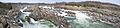
Great Falls is located in Northern Virginia, about 15 miles (24 km) west of Washington, D.C.. It sits on the Potomac River, which forms its northern and eastern borders. The community is named after the amazing Great Falls of the Potomac River, which are on its eastern side.
Many smaller streams, called tributaries, flow through Great Falls and into the Potomac River. These include Nichols Run, Clarks Branch, and Difficult Run. Difficult Run also forms the southern border of the community.
Great Falls covers an area of about 25.66 square miles (66.46 square kilometers). Most of this area is land, with a small part being water.
Because it's so close to Washington, D.C., Great Falls is part of the larger Washington Metropolitan Area. It is surrounded by other communities like Potomac, Maryland, McLean, Virginia, and Reston, Virginia.
People and Population
Great Falls is known for being one of the wealthiest communities in the United States. In 2022, Veranda magazine even included it on their list of richest cities.
In 2020, there were about 15,953 people living in Great Falls. Most households were families, especially married couples. The average family had about three people.
The community has a mix of different backgrounds. Many people speak languages other than English at home, and a good number were born outside the United States. Most adults in Great Falls have a college degree or higher.
The population of Great Falls has grown quite a bit over the years. For example, between 2000 and 2010, the number of people living here increased by over 80%. This was partly because the community's borders were expanded.
Education in Great Falls
Public schools in Great Falls are managed by Fairfax County Public Schools. Younger students attend Great Falls Elementary School, Forestville Elementary School, or Colvin Run Elementary School.
After elementary school, students usually go to James Fenimore Cooper Middle School. Then, they move on to Langley High School.
There is also a private school called Siena Academy. It's a Catholic Montessori school for preschool and elementary students.
For reading and learning, the Fairfax County Public Library operates the Great Falls Library.
Transportation
The main roads that help people get around Great Falls are Virginia State Route 7, also known as Leesburg Pike, and Virginia State Route 193, called Georgetown Pike.
Parks and Fun Things to Do
Even though many people who live in Great Falls work in Washington, D.C., there are some great places to visit right in the community.
One of the most popular spots is Great Falls Park. This park offers amazing views of the Great Falls of the Potomac River, which is where the community gets its name. Long ago, George Washington helped build a canal around the falls on the Virginia side. It was called the Patowmack Canal, but it wasn't very successful for shipping goods. You can still see parts of the canal and an old village called Matildaville in the park today.
Another fun place is River Bend County Park. The Village Green is also a popular gathering spot. It hosts community events throughout the year, like a Spring Festival with an Egg Hunt, Fourth of July celebrations, Halloween fun, Thanksgiving events, and a Christmas Tree Lighting. They even have concerts in the summer!
Famous People from Great Falls
Because Great Falls is so close to Washington, D.C., many important people from American politics and government have lived here. Some of these include Senator Rick Santorum, former FBI director Louis Freeh, and former CIA director Stansfield Turner.
Other well-known residents have included Governor Glenn Youngkin, political writer Peggy Noonan, businesswoman Jacqueline Mars, and businessman Steve Case.
See also
 In Spanish: Great Falls (Virginia) para niños
Images for kids
-
Great Falls on February 21, 2007
