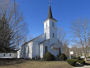
Wolfeboro Falls, New Hampshire facts for kids
Quick facts for kids
Wolfeboro Falls, New Hampshire
|
|
|---|---|

First Baptist Church
|
|
| Country | United States |
| State | New Hampshire |
| County | Carroll |
| Town | Wolfeboro |
| Elevation | 518 ft (158 m) |
| Time zone | UTC-5 (Eastern (EST)) |
| • Summer (DST) | UTC-4 (EDT) |
| ZIP code |
03896
|
| Area code(s) | 603 |
| GNIS feature ID | 870972 |
Wolfeboro Falls is a small place in New Hampshire, United States. It's called an "unincorporated community." This means it's a group of homes and businesses that are part of a larger town, but they don't have their own separate local government. Wolfeboro Falls is actually part of the town of Wolfeboro.
This community is located in Carroll County. It sits about half a mile north of the main part of Wolfeboro. Wolfeboro Falls is special because it's on a narrow strip of land between two lakes. One side is Front Bay, which connects to the big Lake Winnipesaukee. The other side is Crescent Lake, which connects to Lake Wentworth.
A small river called the "Smith River" flows between these two lakes. It drops about 28 feet over its short course of about 0.3 miles. This drop creates the "falls" in Wolfeboro Falls.
Getting Around Wolfeboro Falls
Wolfeboro Falls is easy to reach by road. New Hampshire Route 28 goes right through the village. If you head north on Route 28, you can go to Ossipee. If you go south, you'll reach Alton.
Another road, New Hampshire Route 109A, starts in the middle of Wolfeboro Falls. It heads northwest. This route can take you to places like Center Tuftonboro and Melvin Village.
Postal Information for Wolfeboro Falls
Even though Wolfeboro Falls is part of the town of Wolfeboro, it has its own special ZIP code. The ZIP code for Wolfeboro Falls is 03896. This is different from the ZIP code used for the rest of Wolfeboro.
 | Bayard Rustin |
 | Jeannette Carter |
 | Jeremiah A. Brown |


