
Wood Springs 2 Fire facts for kids
Quick facts for kids Wood Springs 2 Fire |
|
|---|---|

The Wood Springs 2 Fire on June 30, 2020
|
|
| Location | Wood Springs, Apache County, Arizona, United States |
| Coordinates | 35°50′06″N 109°23′10″W / 35.835°N 109.386°W |
| Statistics | |
| Date(s) | June 27, 2020– |
| Burned area | 12,861 acres (5,205 ha) |
| Cause | Lightning strike |
| Buildings destroyed | 2 |
| Map | |

Location in Arizona
|
|
The Wood Springs 2 Fire was a large wildfire that happened in the Navajo Nation in Arizona, United States. It started about 3 miles (5 km) east of Wood Springs, Arizona. A lightning strike caused the fire. It was first seen on June 27, 2020.
The fire grew to cover about 12,861 acres (5,205 hectares). By July 13, 2020, firefighters had it 98 percent under control. The fire destroyed two small buildings and five animal pens. It also damaged one home and threatened the area around Fluted Rock, Arizona.
Contents
How the Fire Started and Grew
June 2020: The Fire Begins
The Wood Springs 2 Fire was first reported on June 27, 2020, around 2:00 PM. It started 3 miles (5 km) east of Wood Springs, Arizona, on the Navajo Nation. A lightning strike caused the fire.
The fire spread quickly because of dry piñon-juniper trees and pine. Firefighters worked hard to stop it. However, strong winds made the fire grow larger. By the evening, it had burned about 300 acres (121 hectares).
Airplanes and helicopters helped fight the fire from above. They used Winslow–Lindbergh Regional Airport as a base. Some roads were closed to keep people safe. These included Navajo Route 7 (from Sawmill to Chinle and Wood Springs) and Navajo Route 26 (from Nazlini to Sawmill).
By June 29, the fire had grown to 3,000 acres (1,214 hectares). People living in Fluted Rock and Sawmill were told to be ready to leave their homes. The fire was very intense, with flames reaching 200 feet (61 meters) high. This was due to wind gusts of 45 miles per hour (72 km/h). The fire even crossed Navajo Route 26 and moved northeast.
July 2020: Firefighting Efforts
By July 1, the fire had damaged some buildings. It kept growing because of dry plants and steep hills. Smoke from the fire caused poor air quality in places like Crystal, New Mexico, Fort Defiance, Arizona, Sawmill, Arizona, and Navajo, New Mexico.
By the evening of July 2, the fire had burned over 10,000 acres (4,047 hectares). Firefighters had only contained 5 percent of it. Crews started checking buildings for damage. They found that one traditional Navajo home, called a hogan, had minor damage. Two animal pens were completely destroyed.
On July 4, firefighters used a drone to help control the fire. The drone dropped special balls that ignited when they hit the ground. This helped burn away fuel in front of the fire, stopping its spread. Two more animal corrals and another building were reported as destroyed.
Jonathan Nez, the President of the Navajo Nation, flew over the fire to see it. He ordered the area around the fire to be closed to the public. By July 7, the community of Sawmill was no longer in danger. The next day, another small building and corral were reported destroyed. This brought the total to two small buildings and five corrals destroyed by the fire.
By July 13, the fire had burned 12,861 acres (5,205 hectares). Firefighters had it 98 percent contained.
Road Closures Due to the Fire

To keep people safe, some roads were closed during the fire. As of July 9, 2020, these roads were only open to local residents:
- Navajo Route 7 from Sawmill to Three Turkey Ruin Junction
- N-26 from the intersection of N-27 east to Route 7
Impact of the Wood Springs 2 Fire
The Wood Springs 2 Fire put several communities in the central Navajo Nation at risk. These included Fluted Rock, Kin Dah Lichíí, Nazlini, Sawmill, and Wood Springs. Some people living there were asked to leave their homes for safety.
The fire also threatened places where sheep and horses were kept. Important cultural and historical sites were also in danger. One hogan (a traditional Navajo home) had minor damage. Two small buildings and five animal pens were completely destroyed.
The fire caused major roads to close, including Navajo Route 7 and Navajo Route 26. Smoke from the fire affected air quality in many areas. People in Sawmill, Flute Rock, Fort Defiance, Arizona, Navajo, New Mexico, and Window Rock, Arizona experienced poor air quality. Smoke could be seen from far away, including from Highway 264, Window Rock, Ganado, Sawmill, Nazlini, and Chinle.
Gallery
-
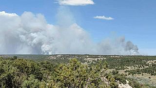
The fire on June 29, as seen from Window Rock
-
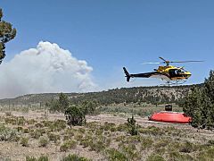
Helicopter procuring water to fight the fire on June 29
-
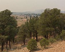
Smoke from the Wood Springs 2 Fire in Navajo, New Mexico on June 30
-
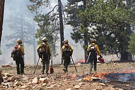
Fire crew monitor burning operations off Route 7 on July 2


