Forest Hills, Boston facts for kids
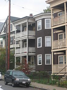
Forest Hills is a hilly and wooded part of the Jamaica Plain neighborhood in Boston, Massachusetts, United States. It's mostly a place where people live, with many homes and some small shops along Hyde Park Avenue. You can find different styles of houses here, like Arts & Crafts, Cape Cod, and Victorian homes. The streets are often curving and lined with trees, showing how this area changed from country estates into a "streetcar suburb" when public transportation arrived.
Contents
Exploring Forest Hills' Past
Early Settlers and Land
The first European known to live in Forest Hills was Captain Joseph Weld in the 1600s. He was a soldier who received a large piece of land in this area. Later, his descendant, Colonel Eleazer Weld, gave some of his land to Benjamin Bussey. This land eventually became the famous Arnold Arboretum, a beautiful plant collection managed by Harvard University.
In the 1800s, as the economy changed from farming to trade, the Weld family started selling their land in smaller pieces. Wealthy families from Boston bought these plots. For some, it was a year-round home, while for others, it was a quiet escape from the city, especially during hot summers or when diseases like cholera were a problem.
Notable Families and Changes
Many important families, like the Welds, Guilds, and Minots, lived in Jamaica Plain for generations. Some of them became very successful. For example, Richard Olney built what might have been Boston's first tennis court. George Minot won a Nobel Prize for his work in medicine.
In the early 1900s, public transportation made it easier for more people to move to Forest Hills. This led many wealthy families to move away, often to other towns or back to fancier parts of Boston.
Forest Hills' Location and Areas
Where is Forest Hills?
Forest Hills isn't an official city area with exact boundaries. Usually, it refers to the neighborhood right around the train station. It also includes the homes on the east side of Hyde Park Avenue, possibly stretching down to Walk Hill Street.
Think of Forest Hills as a rough triangle between Hyde Park Avenue, American Legion Highway, and Morton Street. However, large cemeteries separate some parts of this triangle from the rest. Walk Hill Street divides this triangle. The blocks south of Walk Hill Street were once called "White City" but are now known as "Woodbourne."
Special Sections of Forest Hills
White City
In 1914, some apartment buildings with light-colored stucco were built on Hyde Park Avenue. They were named "White City" after a famous fair called the World's Columbian Exposition. Local businesses also used this name. This area became known as a section of Forest Hills.
It's important to know that "White City" was just a name based on the color of the buildings. It did not mean that only white people lived there. Jamaica Plain has always been a diverse area, with people from many backgrounds.
Woodbourne
Quick facts for kids |
|
|
Woodbourne Historic District
|
|
| Location | Roughly bounded by Walk Hill, Goodway, and Wachusett Sts., Boston, Massachusetts |
|---|---|
| Built | 1911 |
| Architect | multiple |
| Architectural style | Queen Anne, Shingle Style, et al. |
| NRHP reference No. | 99000593 |
| Added to NRHP | June 04, 1999 |
The Woodbourne Historic District is a historic neighborhood in Forest Hills. It's about 30 acres of land developed between 1890 and 1933 by a financier named Robert Winsor. He wanted to create a nice community for middle-class families. Frederick Law Olmsted Jr., a famous landscape designer, helped plan some of its streets.
Many homes in Woodbourne look like charming gabled English cottages, often built around a shared courtyard. Even though it was possible to make the land flat, developers chose to keep the natural hills and bumps. This helped the area feel more like a country estate.
Since 1999, Woodbourne has been a historic district. This means homes there are often advertised as being in "Woodbourne" instead of just "Forest Hills." However, Woodbourne was always planned to be close to the train station and was considered part of Forest Hills by its residents for many years.
Parks, Cemeteries, and Green Spaces
Forest Hills is surrounded by parts of the Emerald Necklace, a famous park system designed by Frederick Law Olmsted in the 1800s. These include the Arnold Arboretum, the Arborway, and Franklin Park.
You can find a baseball field at the top of Wachusett Street, next to the Parkman Playground. There are also small, unnamed wooded areas. You might even spot large rocks called Roxbury puddingstone sticking out of the ground in parks and unexpected places.
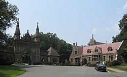
A big part of Forest Hills is taken up by Forest Hills Cemetery. It's an active cemetery, but it's also enjoyed as a large park and arboretum (a place with many different trees and plants). It's considered one of the best 19th-century rural cemeteries in the country. Famous people like Eugene O'Neill and William Lloyd Garrison are buried here. Other large cemeteries nearby include St. Michael's Cemetery and Calvary Cemetery. Together, these cemeteries create a quiet, open space that separates Forest Hills from other neighborhoods.
Education in Forest Hills
Parkman School
In 1896, the City of Boston built a school at the corner of Wachusett Street and Walk Hill Street. It was named after Francis Parkman, a local scholar.
Over the years, the Francis Parkman School has hosted different educational programs. In 2009, the Boston Teachers Union (BTU) Pilot school moved into the building.
Seaver School
In the late 1920s, the city built the Seaver School between Eldridge Road and Northbourne. It was a red brick building designed in the Georgian Revival style and finished in 1930. The school was named after Edwin P. Seaver, who was the Superintendent of Schools in Boston from 1880 to 1904. For many years, this school taught children from kindergarten through eighth grade.
In 1983, the Edwin P. Seaver building was sold and turned into apartments. It's now one of the largest residential buildings in Forest Hills. The old schoolyards are now used for parking.
Churches in Forest Hills
Former St. Andrew's Parish (now Bethel AME Church)
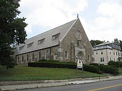
St. Andrew the Apostle Church was built in 1918. It stands on the corner of Walk Hill Street and Wachusett Street. In 1942, St. Andrew the Apostle School opened next to the church. Nuns lived in a convent nearby and taught at the school.
For much of the 20th century, Forest Hills was home to many Irish Catholic families, and St. Andrew's Parish was a central part of the community. Even though the area became more diverse over time, the church remained important.
St. Andrew's Church closed in 2000, and the school closed in 2005. In 2008, the church, school, and other buildings were bought by the Bethel African Methodist Church. This church has since leased parts of the buildings to schools like the MATCH Charter School and the Young Achievers Pilot School.
Upham Church
Upham Memorial Church, a small Methodist church, was finished in 1901 at the corner of Wachusett and Patten Streets. It was designed in a Tudor Revival style, with a corner tower and half-timbering.
As the area became more Catholic after World War II, fewer people attended the Methodist church. It closed in 1969 and was later bought by the Knights of Columbus in 1977. The building was later converted into apartments after a school program that used it moved to a new location.
Transportation in Forest Hills
Forest Hills Station
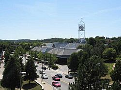
Forest Hills is a major transportation hub, served by the Forest Hills Station. This station is the southern end of the Orange Line subway and a stop on the Commuter Rail. Many bus routes also start or stop here, connecting Forest Hills to other parts of Boston and beyond.
The train station helped the area grow after the Boston & Providence Railroad opened in 1834. The area got its name from the nearby cemetery, which was established in 1848.
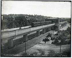
The first Forest Hills Station was a large brick building from the 1800s. In the early 1900s, elevated train tracks were built, connecting to Boston's subway system. The old station and elevated tracks were taken down in the late 1980s. The current, modern station with its clock tower was completed in 1987.
Toll Gate Bridge
Before trains, the area where the Forest Hills Station now stands was called "Toll Gate." In the early 1800s, private roads called turnpikes were built to connect Boston to other cities like Providence and Hartford. Wagons and carts had to pay a toll here before using these roads.
The turnpikes eventually became public roads. In 1874, the main road was renamed Washington Street. Even after the train station became "Forest Hills," the name "Toll Gate" lived on in the Toll Gate Bridge. This metal footbridge crossed the railroad tracks to Washington Street.
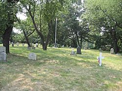
The Toll Gate Bridge was removed in 2012 because it was old and a new crossing point was available. Next to where the footbridge used to be, there's a small, old graveyard called Tollgate Catholic graveyard. It has headstones from the 1800s and early 1900s.
|


