
Woodstock (village), Vermont facts for kids
Quick facts for kids
Woodstock, Vermont
|
|||||||||||||||||||||||||||
|---|---|---|---|---|---|---|---|---|---|---|---|---|---|---|---|---|---|---|---|---|---|---|---|---|---|---|---|
|
Village
|
|||||||||||||||||||||||||||

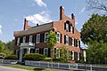
General Lyman Mower House on the Green
|
|||||||||||||||||||||||||||
_highlighted.svg)
Location in Windsor County and the state of Vermont.
|
|||||||||||||||||||||||||||
| Country | United States | ||||||||||||||||||||||||||
| State | Vermont | ||||||||||||||||||||||||||
| County | Windsor | ||||||||||||||||||||||||||
| Area | |||||||||||||||||||||||||||
| • Total | 1.21 sq mi (3.14 km2) | ||||||||||||||||||||||||||
| • Land | 1.18 sq mi (3.06 km2) | ||||||||||||||||||||||||||
| • Water | 0.03 sq mi (0.08 km2) | ||||||||||||||||||||||||||
| Elevation | 702 ft (214 m) | ||||||||||||||||||||||||||
| Population
(2020)
|
|||||||||||||||||||||||||||
| • Total | 900 | ||||||||||||||||||||||||||
| • Density | 762/sq mi (294.1/km2) | ||||||||||||||||||||||||||
| Time zone | UTC-5 (Eastern (EST)) | ||||||||||||||||||||||||||
| • Summer (DST) | UTC-4 (EDT) | ||||||||||||||||||||||||||
| ZIP code |
05091
|
||||||||||||||||||||||||||
| Area code(s) | 802 | ||||||||||||||||||||||||||
| FIPS code | 50-85900 | ||||||||||||||||||||||||||
| GNIS feature ID | 1460316 | ||||||||||||||||||||||||||
|
|||||||||||||||||||||||||||
Woodstock is a small, charming village in Windsor County, Vermont, United States. It's part of the larger town of Woodstock. In 2020, about 900 people lived in the village. It's known for its beautiful historic buildings and friendly atmosphere.
Contents
Exploring Woodstock's Location
Woodstock village covers about 1 square mile (2.7 square kilometers) of land. The Ottauquechee River flows right through the village, adding to its scenic beauty.
A Look at Woodstock's History
The Woodstock Village Historic District is a special area recognized for its historical importance. It was added to the National Register of Historic Places in 1973. This district includes the village center and other properties along the Ottauquechee River.
The historic district is about 275 acres and has 95 buildings, sites, and structures that show the area's rich past. At the heart of the district is a pretty oval-shaped village green. This green is where U.S. Route 4 and Vermont Route 106 meet.
Around the green and along the river's main road, you'll find many homes, shops, and public buildings. These buildings show different architectural styles from the late 1700s to the late 1800s. Some famous spots include:
- The Norman Williams Public Library
- The Billings Farm and Museum
- The George Perkins Marsh Boyhood Home, which is a key part of the Marsh-Billings-Rockefeller National Historical Park
- F. H. Gillingham & Sons, Vermont's oldest general store still run by the same family!
Woodstock: A Great Place to Visit
In 2011, the Downtown Woodstock Streetscape was named a "2011 Great Place in America" by the American Planning Association. This award recognized its streets as "complete," meaning they are good for walking, biking, and driving, not just cars.
The streets specifically honored were North and South Park Streets, part of Elm Street, and two blocks of Central Street. Woodstock's buildings mostly feature early 19th-century New England architecture. "The Green" in the village center is used for weekly farmer markets in the summer and fall. Woodstock is a charming New England village, perfect for exploring on foot.
To encourage smart growth, Vermont created a special district in 2006 for tax credits and other state help. Today, Downtown Woodstock even has a free trolley in the summer. What's cool is that this trolley runs on electricity made from cow manure from local farms!
Woodstock's Population Over Time
| Historical population | |||
|---|---|---|---|
| Census | Pop. | %± | |
| 1880 | 1,266 | — | |
| 1890 | 1,218 | −3.8% | |
| 1900 | 1,284 | 5.4% | |
| 1910 | 1,383 | 7.7% | |
| 1920 | 1,252 | −9.5% | |
| 1930 | 1,312 | 4.8% | |
| 1940 | 1,325 | 1.0% | |
| 1950 | 1,326 | 0.1% | |
| 1960 | 1,415 | 6.7% | |
| 1970 | 1,154 | −18.4% | |
| 1980 | 1,178 | 2.1% | |
| 1990 | 1,037 | −12.0% | |
| 2000 | 977 | −5.8% | |
| 2010 | 900 | −7.9% | |
| 2020 | 900 | 0.0% | |
| U.S. Decennial Census | |||
As of the census in 2000, there were 977 people living in Woodstock village. There were 434 households, and about half of them (220) were families. The village had about 944 people per square mile.
About 18.4% of the population was under 18 years old. The median age was 44 years. This means half the people were younger than 44, and half were older.
Images for kids
-
General Lyman Mower House on the Green
Related Topics
- Woodstock, Vermont
- Marsh-Billings-Rockefeller National Historical Park
- National Register of Historic Places listings in Windsor County, Vermont
- Frederick H. Billings
- F. H. Gillingham & Sons
- Woodstock Railway
See also
 In Spanish: Woodstock (condado de Windsor, Vermont) para niños
