Worlebury Camp facts for kids
Quick facts for kids Worlebury Camp |
|
|---|---|
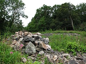
A picture of the present-day site
|
|
| Location | North Somerset, Somerset, England |
| Built | During the Iron Age |
| Architectural style(s) | British pre-Roman Architecture |
| Official name: Worlebury Camp | |
| Reference no. | 22841 |
| Lua error in Module:Location_map at line 420: attempt to index field 'wikibase' (a nil value). | |
Worlebury Camp is an ancient Iron Age hillfort located on Worlebury Hill in Somerset, England. It's found north of Weston-super-Mare. This old fort was very well protected. It had many walls, raised earth banks, and ditches around it.
People have found large triangular platforms on the hillsides below the fort. There were also almost 100 storage pits dug into the solid rock. Many of these pits contained human remains, old coins, and other interesting objects. Over the years, especially in the 1800s and 1900s, the fort was damaged. It was even in danger of being completely destroyed several times. Today, Worlebury Camp is a special protected site called a Scheduled monument. It's also part of the Weston Woods Local Nature Reserve.
Contents
Exploring Worlebury Camp
People have been exploring Worlebury Camp for over 150 years. Some experts believe that the Goidel or Brython people first built the camp. Later, the Belgae people took over the camp. Finally, the Romans arrived and defeated the Belgae.
The first big dig at Worlebury Camp happened from 1851 to 1852. Charles William Dymond, Edwin Martin Atkins, and Francis Warre led this work. Charles Dymond came back in 1880 and continued digging until 1881.
Many years later, in 1987 and 1988, the Woodspring Museum from Weston-super-Mare did more excavations. The latest study of the site was done in 1998 by the Avon Extensive Urban Study team. More recently, in 2018-2019, Historic England surveyed the site. This survey helped answer some questions about the fort's use, but many mysteries still remain.
Where is Worlebury Camp?
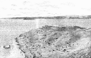
The fort sits on top of Worlebury Hill. It is about 109 metres (358 feet) above sea level. You can find it in North Somerset, above the seaside town of Weston-super-Mare. It is also near the village of Worle.
From the fort, its ancient inhabitants could see far across the land. They could spot any potential invaders coming their way. They would have seen places like Sugar Loaf Mountain, the Black Mountains, the Mendip Hills, Dunkery Beacon, Sand Point, and even Wales. Today, this view is not as clear because many trees have grown on the hill.
Amazing Discoveries
Triangular Platforms
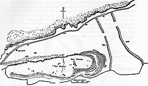
Around the fort, on the slopes, there are several triangular platforms. These platforms are flat on top. Their front edges are about 1.7 metres (5.6 feet) high. There are also ditches in front of them for better defense.
Experts think these platforms might have been used by slingers or archers. Slingers would stand on them to throw stones at attackers. Many sling stones have been found nearby, which supports this idea. Charles Dymond wrote that many stones were broken, as if they had been used in a fight.
Strong Walls and Ditches
Worlebury Hill has very steep cliffs on its north and west sides. These cliffs drop down into the Bristol Channel. This made the fort almost impossible to attack from those directions. Even so, the fort still had walls very close to the cliff edges on these sides.
On the south side, a single wall and a ditch protected the fort. The flat east side was the most vulnerable. It was guarded by two stone walls and five ditches! Some parts of these walls were over 11 metres (35 feet) high in 1875, measured from the bottom of the ditch.
The walls themselves are about 1 metre (3.3 feet) thick. They were built with dry-laid stones, meaning no mortar was used. To stop attackers from easily pulling stones out, the fort's builders piled up rubble at the base of the walls. These rubble barriers were over 1.22 metres (4 feet) high and thick in some places. Attackers would have had to clear this rubble first, all while being attacked by defenders on the wall.
Storage Pits
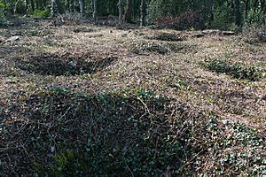
Inside the fort's outer wall, there are hut circles and 93 storage pits. These pits were dug right into the solid rock, which is only about 60 centimetres (2 feet) below the ground.
The pits vary in size. On average, they are about 2 metres (6.6 feet) long and wide, and 1.5 metres (4.9 feet) deep. The largest pit is roughly triangular, with sides measuring 3 metres (9.8 feet), 2.7 metres (8.9 feet), and 2.4 metres (7.9 feet). The smallest is 1 metre (3.3 feet) long and 0.7 metres (2.3 feet) wide.
The people living here used these pits to store grain. Evidence for this includes kernels of barley and wheat, and pieces of pots found inside. Some pits also had peas and burnt remains of woven baskets. Other items found include sling stones and spindle whorls from around 100 or 200 BC.
Human Remains
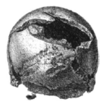
Eighteen of these pits contained human skeletons. These skeletons are now kept at the Weston-super-Mare Museum. Ten of the eighteen full skeletons show signs of a violent death, including sword cuts on the skulls. It is possible that the Romans or Belgic raiders attacked the fort and killed the people living there.
Ancient Artefacts
Archaeologists found a special copper alloy collar at the site. This collar might suggest that the hilltop was used even before the Iron Age. Similar items are often found with Bronze Age objects. This was the first collar of its kind found in Britain.
Roman coins have also been found at Worlebury Camp. The Romans had a presence in the area by the end of the 1st century AD. Many of the Roman coins show the image of the Roman Emperor Honorius.
Other interesting findings include animal bones from pigs, oxen, horses, deer, goats, and even small birds. Limpet shells were also discovered. Iron objects, like a chisel, spearheads, and javelin heads, were found. These iron items further prove that the fort is from the Iron Age. Stone tools, mostly slingstones and scrapers, have been found too. There are also flint chips, some of which might be arrowheads. One good-quality arrowhead was found. A lead lump, probably a sling bullet, was also recorded. Pottery, including Glastonbury type bead-rim pottery, was found. A bronze axe from the late Bronze Age, found in 1883, is now in the Ashmolean Museum.
Damage to the Site
1800s Damage
The growth of Weston-super-Mare since the 1800s has caused damage to the fort. In 1815, a quarry started on the south side of Worlebury Hill. It mined for minerals and stone. When the Bristol and Exeter Railway arrived in Weston-super-Mare in 1841, the village grew into a town. There were plans to build houses right over the hill, which would have gone through Worlebury Camp. However, this expansion never reached the fort itself.
1900s Damage
In the early 1900s, the Worlebury fort was damaged by boys rolling stones down the hill. Some of these stones were even taken from the fort's walls. The local archaeological society took steps to stop this from happening again.
Modern Day Challenges
Some trees planted in the early 1800s grew very large. Their roots started to damage the ancient structures underground. In 2005, the Forestry Commission allowed North Somerset Council to cut down 300 trees. This was to reduce the risk of further damage. A council member explained that a big storm could destroy the entire hillfort if the trees fell.
In 2017, the site was added to the Heritage at Risk Register. This meant its condition was getting worse. Surveys showed some things about the fort's history, but many questions remain. In 2020, the council started discussions about removing even more trees to protect the ancient remains.
 | Madam C. J. Walker |
 | Janet Emerson Bashen |
 | Annie Turnbo Malone |
 | Maggie L. Walker |


