
Worongary facts for kids
Quick facts for kids WorongaryGold Coast City, Queensland |
|||||||||||||||
|---|---|---|---|---|---|---|---|---|---|---|---|---|---|---|---|
.png)
Worongary Creek
|
|||||||||||||||

Worongary
Location in Gold Coast, Australia
|
|||||||||||||||
| Population | 6,021 (2021 census) | ||||||||||||||
| • Density | 427.0/km2 (1,106/sq mi) | ||||||||||||||
| Postcode(s) | 4213 | ||||||||||||||
| Area | 14.1 km2 (5.4 sq mi) | ||||||||||||||
| Time zone | AEST (UTC+10:00) | ||||||||||||||
| Location |
|
||||||||||||||
| LGA(s) | City of Gold Coast | ||||||||||||||
| State electorate(s) | Mudgeeraba | ||||||||||||||
| Federal Division(s) | Wright | ||||||||||||||
|
|||||||||||||||
Worongary is a suburb located in the beautiful City of Gold Coast, Queensland, Australia. It's a great place to live, with a mix of homes and natural areas. In 2021, about 6,021 people called Worongary home.
Contents
Exploring Worongary's Geography
Worongary has a varied landscape. The eastern side of the suburb runs along the Pacific Motorway. This is a major road that helps people travel around.
You'll find a large area of trees in the north-west, used for growing timber. The north-eastern part has more houses, while the middle and south have bigger blocks of land, often like small farms. These larger areas are perfect for people who want more space.
A Look at Worongary's History
The name Worongary comes from an Aboriginal word, Whorrongary. It means either "vine" or "flight of a pigeon." This shows the area's deep connection to its original inhabitants.
Key Dates in Worongary's Past
- 1993: Worongary State School first opened its doors on February 1st.
- 1995: Hinterland Baptist Church was started. Its building was moved from another spot to its current location.
Who Lives in Worongary?
The number of people living in Worongary has been growing.
- In 2016, there were 5,613 people living here.
- By 2021, the population grew to 6,021 people.
Worongary's Special Heritage Sites
Worongary has some places that are important to its history. These are called heritage-listed sites. They are protected so future generations can learn from them.
- Schmidt Farmhouse: Located at 8 Worongary Road, this old farmhouse is a significant historical building. It tells a story about the early settlers in the area.
Learning in Worongary
Worongary offers good education options for younger students.
Worongary State School

Worongary State School is a government primary school. It teaches boys and girls from Prep (the first year of school) to Year 6. The school is on Delta Cove Drive. In 2018, it had almost 700 students and many dedicated teachers and staff. The school also has a special program for students who need extra support.
Nearby High Schools
There aren't any high schools directly in Worongary. Older students usually go to nearby government high schools like Nerang State High School in Nerang or Robina State High School in Robina.
Community Life and Amenities
Worongary has several places that help the community connect and enjoy activities.
Mudgeeraba Showgrounds
Even though it's called Mudgeeraba Showgrounds, this large area is actually in Worongary, at 115 Mudgeeraba Road. It's a popular spot for events and gatherings.
Local Community Groups
- The Springbrook Mudgeeraba branch of the Queensland Country Women's Association meets at the Bill Deacon Pavilion, which is part of the Mudgeeraba Showgrounds. This group helps women in rural areas.
Places of Worship
- Hinterland Baptist Church is located on Hinkler Drive.
- The Church of Jesus Christ of Latter Day Saints can be found on Mudgeeraba Road.
Parks and Green Spaces
Worongary is home to many parks and reserves. These green spaces are perfect for outdoor activities, playing, and enjoying nature. Some of these parks include:
- Alice Bowden Reserve
- Alkira Park
- Delta Reserve
- Fred Cass Family Park
- Graham Dillon Park
- Lawrance Hinde Park
- Mudgeeraba Road Parklands
- Nabarlek Park
- Pioneer Downs Park
- Worongary Creek Reserve
Exciting Events in Worongary
One of the biggest events in Worongary is the annual Mudgeeraba Show.
The Mudgeeraba Show
The Mudgeeraba Show Society organizes this agricultural show every year in June at the Showgrounds. It's a fun event where you can see farm animals, local crafts, and enjoy rides and entertainment.
Interesting Attractions to Visit
Worongary also has a special museum that teaches about history.
Gold Coast Light Horse Education Museum
This museum is at 8 Worongary Road, right next to the Mudgeeraba Showgrounds. It's a great place to learn about the Australian Light Horse. These were brave soldiers who rode horses and served in wars like the Second Boer War and World War I. The museum also shares information about national service in Australia, which is when people serve their country.
Images for kids
-
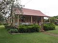
Schmidt Farmhouse, 2016
-
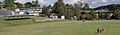
Sports field, Worongary State School, circa 2022

