Wyoming County, Pennsylvania facts for kids
Quick facts for kids
Wyoming County
|
|
|---|---|
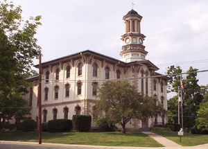
The Wyoming County courthouse in Tunkhannock
|
|
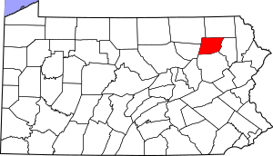
Location within the U.S. state of Pennsylvania
|
|
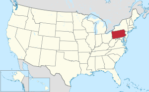 Pennsylvania's location within the U.S. |
|
| Country | |
| State | |
| Founded | April 4, 1842 |
| Named for | Wyoming Valley |
| Seat | Tunkhannock |
| Largest borough | Tunkhannock |
| Area | |
| • Total | 405 sq mi (1,050 km2) |
| • Land | 397 sq mi (1,030 km2) |
| • Water | 7.7 sq mi (20 km2) 1.9% |
| Population
(2020)
|
|
| • Total | 26,069 |
| • Density | 66/sq mi (25/km2) |
| Time zone | UTC−5 (Eastern) |
| • Summer (DST) | UTC−4 (EDT) |
| Congressional district | 9th |
Wyoming County is a special area in Pennsylvania. It is called a county. In 2020, about 26,069 people lived here. The main town, or county seat, is Tunkhannock.
Wyoming County was created in 1842. It was formed from a part of Luzerne County. This county is in the Northeast Pennsylvania region. It is also part of the larger Scranton—Wilkes-Barre—Hazleton area.
Contents
Geography of Wyoming County
Wyoming County covers about 405 square miles. Most of this area is land. About 7.7 square miles is water. The Susquehanna River flows through the county. Other large creeks like Tunkhannock and Mehoopany also drain the land.
The land here is mostly hilly or mountainous. You can find mountains like Mehoopany, Tunkhannock, Knob, and Bowman's. The soil is good for farming. There is also a lot of timber, coal, and iron.
Climate in Wyoming County
Wyoming County has a humid continental climate. This means it has warm summers and cold winters. In Tunkhannock, the average temperature in January is about 25 degrees Fahrenheit. In July, it's around 71 degrees Fahrenheit.
Neighboring Counties
Wyoming County shares borders with these other counties:
- Susquehanna County (to the north)
- Lackawanna County (to the east)
- Luzerne County (to the south)
- Sullivan County (to the west)
- Bradford County (to the northwest)
Main Roads
Several important roads pass through Wyoming County. These roads help people travel around the area.
 US 6
US 6 US 11
US 11 PA 29
PA 29 PA 87
PA 87 PA 92
PA 92 PA 107
 PA 187
 PA 267
 PA 292
 PA 307
 PA 309
 PA 367
People of Wyoming County
| Historical population | |||
|---|---|---|---|
| Census | Pop. | %± | |
| 1850 | 10,655 | — | |
| 1860 | 12,540 | 17.7% | |
| 1870 | 14,585 | 16.3% | |
| 1880 | 15,598 | 6.9% | |
| 1890 | 15,891 | 1.9% | |
| 1900 | 17,152 | 7.9% | |
| 1910 | 15,509 | −9.6% | |
| 1920 | 14,101 | −9.1% | |
| 1930 | 15,517 | 10.0% | |
| 1940 | 16,702 | 7.6% | |
| 1950 | 16,766 | 0.4% | |
| 1960 | 16,813 | 0.3% | |
| 1970 | 19,082 | 13.5% | |
| 1980 | 26,433 | 38.5% | |
| 1990 | 28,076 | 6.2% | |
| 2000 | 28,080 | 0.0% | |
| 2010 | 28,276 | 0.7% | |
| 2020 | 26,069 | −7.8% | |
| U.S. Decennial Census 1790-1960 1900-1990 1990-2000 2010-2017 2010-2020 |
|||
In 2000, there were 28,080 people living in Wyoming County. Most people were White (98.28%). Other groups included Black or African American, Asian, and Native American. About 0.67% of the people were Hispanic or Latino.
Many families lived in the county. About 33.20% of households had children under 18. The average family had about 3 people. The median age was 38 years old. This means half the people were younger than 38, and half were older.
2020 Census Information
Here is a quick look at the different groups of people in Wyoming County from the 2020 census:
| Race | Num. | Perc. |
|---|---|---|
| White (NH) | 24,142 | 92.6% |
| Black or African American (NH) | 214 | 0.82% |
| Native American (NH) | 32 | 0.12% |
| Asian (NH) | 115 | 0.44% |
| Pacific Islander (NH) | 3 | 0.01% |
| Other/Mixed (NH) | 982 | 3.76% |
| Hispanic or Latino | 581 | 2.22% |
Education in Wyoming County
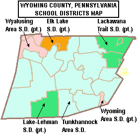
Wyoming County has several public school districts. Some of these districts also serve parts of neighboring counties.
Public School Districts
- Elk Lake School District
- Lackawanna Trail School District
- Lake-Lehman School District
- Tunkhannock Area School District
- Wyalusing Area School District
- Wyoming Area School District
Colleges and Universities
- Keystone College is a college located partly in Wyoming County.
Transportation in Wyoming County
Wyoming County has an airport called Skyhaven Airport. It is near Tunkhannock.
Long ago, the Susquehanna River banks were used for rail transport. Trains carried people and goods between cities like New York, Philadelphia, and Buffalo. Today, most train tracks are on the east side of the river. They are mainly used for moving goods. Norfolk Southern operates these tracks.
You can also travel through Wyoming County using major roads. Pennsylvania Route 29 and Pennsylvania Route 92 are important north-south and east-west roads. U.S. Route 6 is also a key route in the region.
Communities in Wyoming County
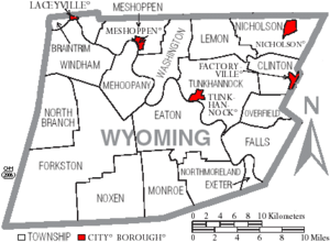
Wyoming County has different types of communities. These include boroughs and townships.
Boroughs
Boroughs are like small towns with their own local government.
- Factoryville
- Laceyville
- Meshoppen
- Nicholson
- Tunkhannock (This is the county seat, the main town.)
Townships
Townships are larger rural areas that also have local governments.
Other Communities
- Census-designated places are areas that look like towns but are not officially incorporated.
- Unincorporated communities are small places without their own local government.
- Bellasylva
- Forkston
- Kasson Brook
- Ghost towns are places where people used to live but are now empty.
Community Population Ranking
This table shows the population of the main communities in Wyoming County, based on the 2010 census.
† county seat
| Rank | City/Town/etc. | Municipal type | Population (2010 Census) |
|---|---|---|---|
| 1 | † Tunkhannock | Borough | 1,836 |
| 2 | Factoryville | Borough | 1,158 |
| 3 | Nicholson | Borough | 767 |
| 4 | Lake Winola | CDP | 748 |
| 5 | Noxen | CDP | 633 |
| 6 | Meshoppen | Borough | 563 |
| 7 | West Falls | CDP | 382 |
| 8 | Laceyville | Borough | 379 |
See also
 In Spanish: Condado de Wyoming (Pensilvania) para niños
 | May Edward Chinn |
 | Rebecca Cole |
 | Alexa Canady |
 | Dorothy Lavinia Brown |


