Yardville, New Jersey facts for kids
Quick facts for kids
Yardville, New Jersey
|
|
|---|---|

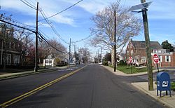
Along South Broad Street (CR 672)
|
|

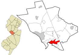
Location in Mercer County and the state of New Jersey
|
|
| Country | |
| State | |
| County | Mercer |
| Township | Hamilton |
| Area | |
| • Total | 4.10 sq mi (10.63 km2) |
| • Land | 4.07 sq mi (10.55 km2) |
| • Water | 0.03 sq mi (0.08 km2) 0.56% |
| Elevation | 59 ft (18 m) |
| Population
(2020)
|
|
| • Total | 6,965 |
| • Density | 1,710.04/sq mi (660.31/km2) |
| Time zone | UTC−05:00 (Eastern (EST)) |
| • Summer (DST) | UTC−04:00 (Eastern (EDT)) |
| ZIP Codes | |
| FIPS code | 34-83170 |
| GNIS feature ID | 02633183 |
Yardville is a small community in Hamilton Township, Mercer County, New Jersey, United States. It is known as an "unincorporated community" and a "census-designated place" (CDP). This means it's a specific area that the government tracks for population data, even though it's not a separate town with its own local government.
In 2020, about 6,965 people lived in Yardville. Before 2010, Yardville was part of a larger area called Yardville-Groveville.
Contents
Exploring Yardville's Location
Yardville is located in the southern part of Mercer County. It shares borders with other communities. To the northwest, you'll find White Horse. To the southeast, it borders Groveville.
Natural Borders and Nearby Cities
The community's southwest side is next to Crosswicks Creek. This creek flows into the Delaware River. Across the creek is Burlington County.
A major highway, Interstate 195, runs along part of Yardville's northern edge. Another important road, U.S. Route 130, goes right through the middle of the community. From Yardville, you can drive about 3 miles (5 km) southwest to Bordentown. If you go northeast, Hightstown is about 9 miles (14 km) away. Trenton, the capital city of New Jersey, is about 6 miles (10 km) northwest of Yardville.
Land and Water Area
The U.S. Census Bureau states that Yardville covers a total area of about 4.10 square miles (10.62 square kilometers). Most of this area is land, about 4.07 square miles (10.54 square kilometers). A small part, about 0.03 square miles (0.08 square kilometers), is water.
Yardville's Population Facts
| Historical population | |||
|---|---|---|---|
| Census | Pop. | %± | |
| 2010 | 7,186 | — | |
| 2020 | 6,965 | −3.1% | |
| U.S. Decennial Census | |||
The population of Yardville has changed a little over time. In 2010, there were 7,186 people living here. By 2020, the population was 6,965. This shows a slight decrease in the number of residents.
Who Lives in Yardville? (2010 Data)
In 2010, there were 2,757 households in Yardville. A household is a group of people living together in one home. Most households, about 61.2%, were married couples. About 9.0% were families with a female head of household and no husband present.
The average household had about 2.60 people. The average family had about 3.03 people.
Age Groups in Yardville
- About 20.0% of the people were under 18 years old.
- About 7.8% were between 18 and 24 years old.
- About 23.5% were between 25 and 44 years old.
- About 32.5% were between 45 and 64 years old.
- About 16.2% were 65 years old or older.
The average age of people in Yardville was 44.3 years. For every 100 females, there were about 96.5 males.
Images for kids
-
Location in Mercer County and the state of New Jersey
See also
 In Spanish: Yardville para niños


