Randsburg, California facts for kids
Quick facts for kids
Randsburg
|
|
|---|---|
 |
|
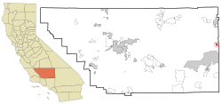
Location in Kern County and the state of California
|
|
| Country | |
| State | |
| County | Kern |
| Area | |
| • Total | 1.945 sq mi (5.038 km2) |
| • Land | 1.906 sq mi (4.937 km2) |
| • Water | 0.039 sq mi (0.101 km2) 2% |
| Elevation | 3,504 ft (1,068 m) |
| Population
(2020)
|
|
| • Total | 45 |
| • Density | 23.14/sq mi (8.93/km2) |
| Time zone | UTC-8 (Pacific) |
| • Summer (DST) | UTC-7 (PDT) |
| ZIP code |
93554
|
| Area codes | 442/760 |
| FIPS code | 06-59668 |
| GNIS feature ID | 1661284 |
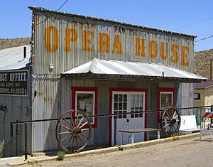
Randsburg, once called Rand Camp, is a small community in Kern County, California. It's known as a census-designated place (CDP). This means it's a place that looks like a town but isn't officially governed as one.
Randsburg is about 17 miles (27 km) south of Ridgecrest. It sits high up at 3,504 feet (1,068 meters) above sea level. In 2020, only 45 people lived there.
Contents
Where is Randsburg?
Randsburg is located at 35°22′07″N 117°39′29″W. It's on the west side of U.S. Route 395. This road runs between Kramer Junction to the south and Ridgecrest to the north.
The town is nestled in the Rand Mountains. A ridge separates Randsburg from its nearby community, Johannesburg. The total area of Randsburg is about 1.945 square miles (5.038 square kilometers). Almost all of this area is land.
What is the Climate Like in Randsburg?
Randsburg has a cold semi-arid climate. This type of climate is found on the western edge of the Mojave Desert. It means the summers are very hot and dry. The winters, however, are cool.
| Climate data for Randsburg, California, 1991–2020 normals, extremes 1937–present | |||||||||||||
|---|---|---|---|---|---|---|---|---|---|---|---|---|---|
| Month | Jan | Feb | Mar | Apr | May | Jun | Jul | Aug | Sep | Oct | Nov | Dec | Year |
| Record high °F (°C) | 84 (29) |
86 (30) |
88 (31) |
96 (36) |
103 (39) |
111 (44) |
114 (46) |
111 (44) |
110 (43) |
98 (37) |
90 (32) |
77 (25) |
114 (46) |
| Mean maximum °F (°C) | 66.7 (19.3) |
69.9 (21.1) |
78.6 (25.9) |
87.0 (30.6) |
94.8 (34.9) |
102.6 (39.2) |
106.4 (41.3) |
104.2 (40.1) |
99.4 (37.4) |
89.8 (32.1) |
77.4 (25.2) |
66.5 (19.2) |
107.1 (41.7) |
| Mean daily maximum °F (°C) | 58.1 (14.5) |
61.4 (16.3) |
67.9 (19.9) |
75.1 (23.9) |
84.4 (29.1) |
94.7 (34.8) |
100.9 (38.3) |
100.1 (37.8) |
92.4 (33.6) |
80.3 (26.8) |
67.2 (19.6) |
57.1 (13.9) |
78.3 (25.7) |
| Daily mean °F (°C) | 46.6 (8.1) |
49.3 (9.6) |
54.4 (12.4) |
60.6 (15.9) |
69.1 (20.6) |
78.6 (25.9) |
84.7 (29.3) |
83.8 (28.8) |
77.0 (25.0) |
66.1 (18.9) |
54.4 (12.4) |
45.8 (7.7) |
64.2 (17.9) |
| Mean daily minimum °F (°C) | 35.1 (1.7) |
37.2 (2.9) |
41.0 (5.0) |
46.1 (7.8) |
53.8 (12.1) |
62.5 (16.9) |
68.5 (20.3) |
67.5 (19.7) |
61.5 (16.4) |
51.9 (11.1) |
41.7 (5.4) |
34.5 (1.4) |
50.1 (10.1) |
| Mean minimum °F (°C) | 24.2 (−4.3) |
27.2 (−2.7) |
30.0 (−1.1) |
34.4 (1.3) |
41.9 (5.5) |
49.1 (9.5) |
59.6 (15.3) |
58.1 (14.5) |
50.4 (10.2) |
39.6 (4.2) |
29.7 (−1.3) |
24.7 (−4.1) |
21.9 (−5.6) |
| Record low °F (°C) | 4 (−16) |
15 (−9) |
16 (−9) |
23 (−5) |
30 (−1) |
39 (4) |
49 (9) |
49 (9) |
38 (3) |
27 (−3) |
12 (−11) |
9 (−13) |
4 (−16) |
| Average precipitation inches (mm) | 1.38 (35) |
1.56 (40) |
0.98 (25) |
0.38 (9.7) |
0.14 (3.6) |
0.03 (0.76) |
0.23 (5.8) |
0.19 (4.8) |
0.19 (4.8) |
0.47 (12) |
0.47 (12) |
0.69 (18) |
6.71 (171.46) |
| Average snowfall inches (cm) | 0.4 (1.0) |
0.3 (0.76) |
0.6 (1.5) |
0.0 (0.0) |
0.0 (0.0) |
0.0 (0.0) |
0.0 (0.0) |
0.0 (0.0) |
0.0 (0.0) |
0.0 (0.0) |
0.1 (0.25) |
0.8 (2.0) |
2.2 (5.51) |
| Average precipitation days (≥ 0.01 in) | 4.0 | 4.5 | 3.5 | 1.7 | 1.0 | 0.2 | 1.1 | 0.7 | 0.7 | 1.3 | 1.8 | 3.3 | 23.8 |
| Average snowy days (≥ 0.1 in) | 0.3 | 0.4 | 0.3 | 0.0 | 0.0 | 0.0 | 0.0 | 0.0 | 0.0 | 0.0 | — | 0.3 | — |
| Source 1: NOAA | |||||||||||||
| Source 2: National Weather Service | |||||||||||||
The History of Randsburg
Randsburg began because of gold! On April 25, 1895, Frederic Mooers, John Singleton, and Charles Burcham found gold. They found it at a place called Yellow Aster Mine. Soon, a mining camp grew there, named Rand Camp. Both the mine and the camp were named after a famous gold mining area in South Africa called Witwatersrand.
The Yellow Aster was the first of many gold mines in the area. The Rand Mining District was officially created on December 20, 1895. By the end of 1896, Rand Camp was renamed Randsburg. More than 1,500 people lived there. The first post office opened in Randsburg in 1896. By October 1897, the mines had produced over $600,000 worth of gold. In 1899, the first stamp mill opened at Yellow Aster. A stamp mill crushes rocks to get the gold out.
To help the Yellow Aster mine produce more gold, a well was dug. Water was pumped from Goler up to the mine. This water helped a second mill operate. The mines in the district were making a lot of money. However, the workers were not paid well. Because of this, the workers went on strike in 1903.
During World War I, the Yellow Aster's gold production went down. It closed in 1918. The mine reopened in 1921 and worked on and off until 1933. Then, a company called Anglo-American Mining Corporation took it over. They sold it in 1940 to John Cummings & Co. This company worked the mine until 1956.
In 1983, a company called Glamis Gold bought the Yellow Aster mine. They used a method called untopping to get more gold. By 2006, all the gold-rich rock was gone. The mining operations stopped for good.
Visiting Randsburg Today
Randsburg gets many visitors throughout the year. Most tourists come between autumn and spring. This is because the summers are extremely hot.
The town has an annual event called the Western Days Celebration. It starts on the third weekend of September. During this time, Randsburg hosts fun events. These include mock gun fights, gold panning, live bands, and dances. There are also many vendors.
During Thanksgiving and New Year's Day weekends, people who love off-roading visit. They use the town's legal off-roading trail. Local shops in Randsburg are usually closed on weekdays. They open their doors on weekends for visitors.
Randsburg in Movies and Videos
Randsburg has been a filming location! The old 1913 movie The Mystery of Yellow Aster Mine was filmed there.
The movie South of Suez, released in 1940, also filmed scenes in Randsburg. This movie starred George Brent.
The music video for Calvin Harris's popular song, Feel So Close, was partly filmed in Randsburg. Also, Dwight Yoakam's 1989 music video for "Long White Cadillac" was shot in the town.
The Rand Mining District
| Rand Mining District | |
|---|---|
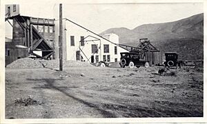
Rand Silver mill in 1920
|
|
| Location | 161 Butte Ave, Randsburg, California, in Kern County, California |
| Official name: Rand Mining District | |
| Designated | May 22, 1957 |
| Reference no. | 938 |
The Rand Mining District is a special place in Randsburg. It is recognized as California Historical Landmark number 938. This landmark was signed on October 12, 1958.
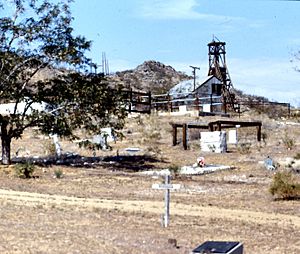
This area was home to important mines. These included the Yellow Aster Mine and the Kelly Mine. These mines helped start the town of Randsburg in 1895. Later, they also led to the towns of Johannesburg, California and Atolia, California.
The Rand Mine was very important for silver. It produced more silver than any other mine in California! However, the mine closed in 1929. It was no longer making enough money to stay open.
In January 1898, the Randsburg Railway opened. This train line ran from Johannesburg to Kramer Junction, California. It also had a stop in Atolia.
The sign for the Rand Mining District California Historical Landmark says:
- NO. 938 RAND MINING DISTRICT - The Yellow Aster, or Rand, mine was discovered in April 1895 by Singleton, Burcham, and Mooers. The town of Randsburg quickly developed, followed by the supply town of Johannesburg in 1896. Both names were adopted from the profusion of minerals resembling those of the ranch mining district in South Africa. In 1907, Churchill discovered tungsten in Atolia. In June 1919, Williams and Nosser discovered the California Rand Silver Mine at Red Mountain.
See also
 In Spanish: Randsburg para niños


