Øresund facts for kids
Quick facts for kids Øresund |
|
|---|---|
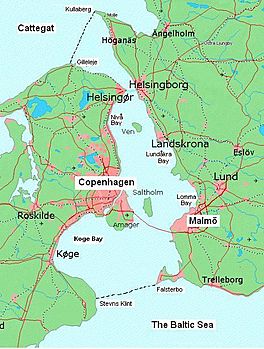
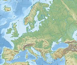
Øresund, showing its northern and southern boundaries
|
|
| Coordinates | 55°45′N 12°45′E / 55.750°N 12.750°E |
| Type | Strait |
| Basin countries | Sweden and Denmark |
| Max. length | 118 km (73 mi) |
| Max. width | 28 kilometres (17 mi) |
| Min. width | 4 km (2.5 mi) |
| Max. depth | −40 m (−130 ft) |
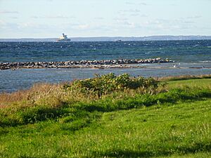
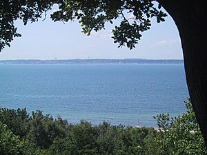
The Øresund (also spelled Öresund) is a narrow stretch of water that forms the border between Denmark and Sweden. It separates the Danish island of Zealand from the Swedish region of Scania.
This strait is about 118 kilometers (73 miles) long. Its width changes, from 4 kilometers (2.5 miles) to 28 kilometers (17 miles). The narrowest part is between Helsingør in Denmark and Helsingborg in Sweden.
The Øresund is one of the busiest waterways in the world. It connects the Baltic Sea to the Atlantic Ocean. Ships travel through it to reach the North Sea and beyond.
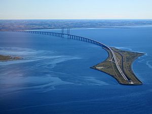
A famous bridge, the Øresund Bridge, connects the Danish capital Copenhagen with the Swedish city of Malmö. It opened in 2000. This bridge helps connect a large area with almost 4 million people.
Another busy route is the HH Ferry route between Helsingør and Helsingborg. More than 70 ferries cross this route every day.
The Øresund is a fairly new strait in terms of geology. It formed about 8,000 to 8,500 years ago. This happened when sea levels rose. Before that, the Baltic Sea was a freshwater lake. When salt water entered through the Øresund, the Baltic Sea became salty.
Contents
What's in a Name?
The strait is called Øresund in Danish and Öresund in Swedish. People sometimes just call it Sundet, which means "the Sound".
The name comes from old words. Øre means "gravel or sand beach". Sund means "sound" or "strait". So, it means "gravel beach strait".
The name was first written down around the year 1000. Many places along the strait have "ör" in their names. Examples include Helsingør, Skanör, and Dragør. These places often had gravel beaches.
Where are the Boundaries of Øresund?
The northern edge of the Øresund is a line from Gilleleje in Denmark to Kullaberg in Sweden. Kullaberg is a small peninsula north of Helsingborg.
To the south, the Øresund meets the Baltic Sea. This boundary goes from Stevns Klint in Denmark to Falsterbo in Sweden.
The eastern side of the strait is the Swedish coastline. To the west, the island of Amager is considered part of the Øresund. Amager is connected to Zealand by many bridges and tunnels. It also has a bridge and railway connection to Sweden.
Water, Animals, and Salinity
The Øresund is unique because it sits between very salty ocean water and the much less salty Baltic Sea. Ocean water has a salinity of over 30 parts per thousand (PSU). The Baltic Sea, in its main part, has only about 7 PSU.
The water conditions in the Øresund can change a lot. The surface currents often flow north, carrying less salty water from the Baltic Sea. However, these currents can change direction daily. The average surface salinity is about 10-12 PSU in the south. It is higher, over 20 PSU, north of Helsingør.
Deeper down, the water is more stable and saltier. Below 10 to 15 meters, the water is always oceanic (over 30 PSU). But in the southern part, the water is only 5-6 meters deep in many places. This shallow depth creates a clear border for many ocean animals.
Only about 52 salt-water species live in the central Baltic Sea. In contrast, around 1,500 species live in the North Sea. About 600 species are found in parts of the Øresund.
Animals like lobsters, small crabs, and some flatfish need salty water to reproduce. The lion's mane jellyfish can drift into the Baltic Sea, but it cannot reproduce there.
The daily tides do not affect the water level much in the Øresund. Strong winds and currents have a much bigger impact. Sometimes, during storms, a lot of salty ocean water can rush into the Baltic Sea. This helps fish like Atlantic cod to breed there. If this doesn't happen for a long time, cod breeding can be in danger.
A Look at History
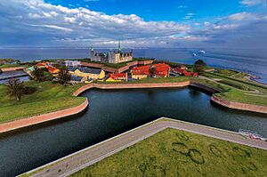
Controlling the Øresund has been very important in the history of Denmark and Sweden. Denmark used to control both sides of the strait. They had Kronborg castle in Elsinore on the west side. On the east side, they had Kärnan in Helsingborg. These fortresses were at the narrowest point of the strait.
In 1658, the eastern shore was given to Sweden. This happened after the Treaty of Roskilde.
In 1429, King Eric of Pomerania started collecting "Sound Dues". This was a tax on ships passing through the strait. This tax lasted for over 400 years, until 1857. These dues were a major source of income for the Danish kings. It made them very powerful.
To avoid these taxes, Sweden started two big projects. They founded the city of Gothenburg in 1621. They also built the Göta Canal between 1810 and 1832. This canal allowed ships to bypass the Øresund.
In 1857, the Copenhagen Convention of 1857 ended the Sound Dues. The Danish straits became an international waterway, meaning all ships could pass freely.
The Øresund Bridge, a fixed connection across the strait, opened in 2000.
Islands in the Øresund
Denmark
- Amager (partly man-made)
- Saltholm
- Peberholm (an artificial island)
- Middelgrundsfortet (an artificial island)
- Flakfortet (an artificial island)
- Amager Strandpark (an artificial beach near Copenhagen)
- Brøndby Strandpark (an artificial beach near Copenhagen)
- Vallensbæk-Ishøj Strandpark (an artificial beach near Copenhagen)
Sweden
- Ven
- Gråen (an artificial island near Landskrona)

Notable Sights Along the Øresund
Denmark
- Køge Bugt (Køge Bay)
- Nivå Bugt (Nivå Bay)
- Kalveboderne
Sweden
- Lundåkrabukten (Lundåkra Bay)
- Lommabukten (Lomma Bay)
- Höllviken
See also
 In Spanish: Estrecho de Øresund para niños
- Great Belt
- Little Belt
- Kiel Canal
- Øresund Region
- Øresund Bridge
- Øresund station on the Copenhagen Metro
- Øresundsmetro - a proposed metro system for Copenhagen and Malmö
 | Leon Lynch |
 | Milton P. Webster |
 | Ferdinand Smith |


