
Ōkārito Lagoon facts for kids
Quick facts for kids Ōkārito Lagoon |
|
|---|---|
| Okarito Lagoon | |

View across Ōkārito Lagoon
|
|

Ōkārito Lagoon
Location in South Island

Ōkārito Lagoon
Location in New Zealand
|
|
| Location | Westland District, West Coast, New Zealand |
| Coordinates | 43°12′S 170°13′E / 43.200°S 170.217°E |
| Type | lagoon |
| Basin countries | New Zealand |
Ōkārito Lagoon is a large coastal lagoon on the West Coast of New Zealand's South Island. It is located about 130 kilometers south of Hokitika. This lagoon covers an area of about 3,240 hectares (about 12.5 square miles). It is the largest natural wetland in New Zealand that has not been changed by humans.
The lagoon is special because it has many different types of plants. These plants range from tall rimu forests to mānuka bushes and plants that grow in salty water. The small settlement of Ōkārito is found at the southern end of the lagoon.
Contents
What's in a Name?
The name of the lagoon comes from the Māori words. Ō means "place of," and kārito refers to the young shoots of the raupō plant. Raupō shoots were an important food source for Māori people.
Another story says that Ōkārito was named after a chief called Kārito. His daughters, Mapourika and Wahapako, gave their names to nearby Lake Mapourika and Lake Wahapo. Since 2010, the official name has been spelled with macrons over the vowels (Ōkārito). However, you might still see it written as "Okarito."
Geography of Ōkārito Lagoon

Ōkārito Lagoon is about 3,240 hectares in size. Most of it is quite shallow. It is the biggest natural wetland of its kind on the West Coast of New Zealand. The lagoon is part of a series of wetlands that stretch for 40 kilometers.
Around the lagoon, there is a low ridge of land. This ridge was left behind by a glacier about 18,000 years ago. The glacier moved up what is now the Whataroa River.
Several small streams flow into the lagoon. The lagoon also gets water from Lake Mapourika and Lake Wahapo through the Ōkārito River. The small town of Ōkārito is at the southern end of the lagoon.
.jpg)
The lagoon is affected by the tides. When the tide is low, large areas of mudflats are uncovered. At these times, canoes can only travel along a main channel. This channel splits into smaller streams and creeks. These smaller waterways lead into tall coastal rainforests with kahikatea and rimu trees. Most of the lagoon is muddy and can only be reached by boat.
The lagoon is always changing, especially because of earthquakes along the Alpine Fault. When an earthquake happens, the bottom of the lagoon can sink and become deeper. But landslides from the mountains also wash sediment into the lagoon. This sediment forms a sandbar, which partly blocks the lagoon from the sea.
When the lagoon is blocked, the water level rises, and a freshwater ecosystem forms. This area is mostly covered by raupō plants. Over time, the sandbar might break, and the water level will drop. Then, the tides can come further inland, creating a mix of fresh and salty water. This is when the rimu forest can grow closer to the lagoon's edges, which you can see today.
Plants of Ōkārito Lagoon

Ōkārito Lagoon has large areas of eelgrass. This is special because most other estuaries in New Zealand have lost their eelgrass due to pollution. Eelgrass is not a seaweed; it's a flowering plant that gets pollinated underwater. Eelgrass beds are very important. They pull nutrients from the mud and provide a home for small creatures and a safe place for baby fish to grow.

On the land side of the lagoon, there are large areas of saltmarsh and swampland. These areas are mostly covered by a plant called jointed wire rush, or oioi (Apodasmia similis). This then changes into a band of mānuka, mingimingi, and flax bushes. These bushes then lead into kahikatea swamp forest, which then turns into a forest mainly of rimu and silver pine (Manoao colensoi) trees.
Ōkārito is one of the few places on the West Coast where you can easily see how the land changes. You can see the tall rainforest turn into scrub, then into rushes, and finally into the salty water of the lagoon. This change can happen over a long distance or just a few meters along a creek bank.
Animals of Ōkārito Lagoon
More than 70 types of birds have been seen at Ōkārito Lagoon and in the nearby forest. This includes 40 kinds of shorebirds and birds that travel long distances. You might see Paradise shelducks, New Zealand scaup, black swans, and sometimes grey ducks on the water.
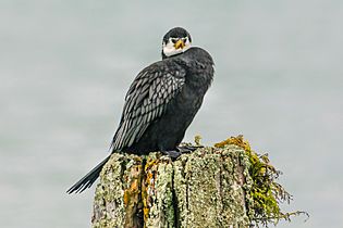
Different types of shags (a kind of bird that dives for fish) live here, like black shags (Phalacrocorax carbo), little shags (P. melanoleucos), and pied shags (P. varius). The most common gulls are the black-billed gulls (Chroicocephalus bulleri), which are the most endangered gull species in the world.
You can also spot white-faced herons, royal spoonbills, and the famous white heron, or kōtuku (Ardea alba modesta). Banded dotterels and variable oystercatchers lay their eggs on Ōkārito Beach.
Fernbirds live all around the lagoon. The Ōkārito Wetland Walk is one of the best places to see these shy birds. They are often found among the oioi rushes. You can hear pairs of fernbirds making a special "u-tick" call to each other. Australasian bitterns and marsh crakes also live in the wetlands, but they are much harder to find.
Young fish called whitebait are common here, especially during the fishing season from September to mid-November. The lagoon is also home to longfin eels, flounder, and yellow-eyed mullet. The muddy areas are home to tunneling crabs (Helice crassa), mudsnails (Amphibola crenata), and mudflat topshells (Diloma subrostratum).
-
Little shag
-
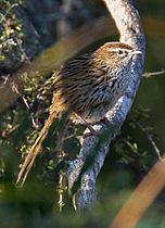
Fernbird
-
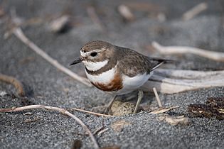
Banded dotterel
-
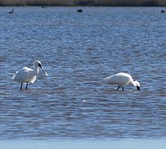
Royal spoonbills


The Kōtuku: A Special Bird

For many New Zealanders, Ōkārito is known for the white heron (Ardea alba modesta). This bird is usually called by its Māori name, kōtuku. Outside New Zealand, it's known as the Eastern great egret. This type of egret is quite common in Asia and Australia. However, in New Zealand, the white heron is very rare. When Queen Elizabeth II visited New Zealand in 1953–54, people compared her to the kōtuku. This was a special compliment given to rare and important visitors. The kōtuku is even shown on the back of a New Zealand $2 coin.
There is only one place in New Zealand where white herons breed. This is at the mouth of the Waitangiroto River, just north of Ōkārito Lagoon. Kōtuku share this breeding spot with royal spoonbills, which are called kōtuku ngutupapa in Māori. After breeding, the kōtuku spread out across New Zealand, but they always come back to this one spot to lay their eggs.
The first European to see this breeding colony was a surveyor named Gerhard Mueller. He was guided there by Kere Tūtoko in 1865. In 1941, there were only four pairs of kōtuku nesting there. That year, the New Zealand government bought the land at Waitangiroto to protect it as a nature reserve.
You can see white herons at Ōkārito Lagoon all year round. They are most common between October and March. You can get quite close to them if you go kayaking on the lagoon. There are also birdwatching tours that visit the colony from Whataroa.
History of Ōkārito
Māori people have lived in the Ōkārito area and gathered food there for over 600 years. Ōkārito was an important mahinga kai (food-gathering place) for Kāti Māhaki ki Makaawhio. This was a group of Ngāi Tahu people who collected and worked pounamu (greenstone) for trading. As part of a special agreement in 1998, Ngāi Tahu were given a nohoanga (seasonal gathering site) at the lagoon. They also had their rights over the lagoon officially recognized.
During the West Coast Gold Rush in the 1860s, Ōkārito grew very quickly. Its population reached several thousand people. It had 31 hotels, three banks, and a courthouse. The port was the third busiest on the West Coast, after Hokitika and Greymouth. It had a wharf, a customs house, and a harbor master. At one point, 500 gold miners arrived in a single day! The harbor master used flags and signals to guide ships safely over the tricky sandbar.
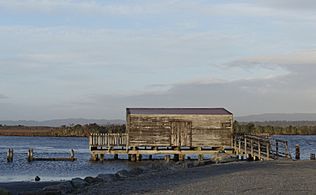
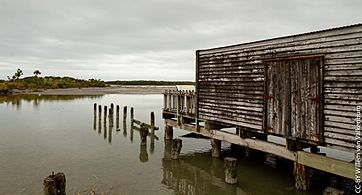
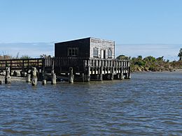
Later, in the late 1800s and early 1900s, flax and timber were sent out from the wharf. Part of the old wharf and its shed are still there today. The shed was rebuilt in 1960 using parts of the original structure. Now, it serves as an information center for visitors.
- Ōkārito Wharf
-
-
-
-


There was once a large island in the lagoon where sports days and horse races were held. It was also the site of Ōkārito's first cemetery.
Protecting Ōkārito Lagoon
Ōkārito Lagoon is New Zealand's largest natural wetland. However, it is not yet officially protected under the Ramsar Convention on Wetlands. This is an international agreement to protect important wetlands. Several suggestions have been made to include it, with the last one in 2017.
The lagoon has been made a mātaiti reserve. This means that local Makaawhio Māori people can gather food there, and people can also fish for fun. However, commercial fishing (fishing for profit) is not allowed. The area between Ōkārito Lagoon and the mountains is part of a big project called "Predator Free South Westland." This project aims to remove rats, stoats, and possums from a huge area of 100,000 hectares.
