
List of earthquakes in New Zealand facts for kids


New Zealand is a country that experiences many earthquakes. This is because it sits on the boundary where two huge pieces of the Earth's crust, called tectonic plates, meet. These plates are the Indo-Australian Plate and the Pacific Plate. They are constantly moving and pushing against each other, which causes the ground to shake.
New Zealand is part of the Ring of Fire, a large area around the Pacific Ocean where many earthquakes and volcanoes happen. Most of New Zealand's earthquakes occur along the mountain ranges that stretch from Fiordland in the southwest to East Cape in the northeast. This line follows the boundary between the two tectonic plates.
About 14,000 earthquakes happen in and around New Zealand every year. Out of these, about 150 to 200 are strong enough for people to feel. Because of this, New Zealand has very strict rules for how buildings must be constructed to withstand earthquakes. Major earthquakes in 1929 and 1931 led to even stronger building rules being put in place from 1935 onwards.
The largest city in the highest-risk earthquake zone is Wellington, the nation's capital. Other cities like Napier and Hastings are also in high-risk areas. All these cities have experienced powerful earthquakes since European settlers arrived. Early settlers quickly learned the importance of building with materials that could handle shaking. For example, after a big earthquake in 1848 damaged many brick buildings in Wellington, the city was mostly rebuilt using wood. This helped it suffer less damage in the massive 1855 earthquake.
| Magnitude | Annual average |
|---|---|
| 4.0–4.9 | 355.9 |
| 5.0–5.9 | 29.28 |
| 6.0–6.9 | 1.66 |
| 7.0–7.9 | 0.26 |
| 8.0 and over | 0.01 |
This article lists some of the most significant earthquakes in New Zealand's history. It mainly focuses on earthquakes with a magnitude of 6.0 or greater. Sometimes, smaller earthquakes are included if they caused a lot of damage or led to deaths. Aftershocks (smaller quakes that happen after a big one) are usually not listed, unless they were very important, like the 2011 Christchurch earthquake.
Contents
Major Earthquakes in New Zealand's History
This section looks at some of the biggest earthquakes that have shaken New Zealand over the years.
Earthquakes Before the 19th Century
Scientists estimate these early earthquakes based on geological evidence.
| Date | Location | Region | Magnitude (MW) | Further information |
|---|---|---|---|---|
| 1460 | Wellington Region | Wellington | 8.0 | Haowhenua earthquake |
| 1717 | Alpine Fault | South Island | 8.1 |
19th Century Earthquakes (1800s)
Information for earthquakes before 1840 are later estimates.
| Date | Location | Region | Magnitude (MW) | Fatalities | Further information |
|---|---|---|---|---|---|
| 8 July 1843 | Near Taihape | Manawatu | 7.6 | 2 | 1843 Wanganui earthquake |
| 16 October 1848 | Blenheim | Marlborough | 7.8 | 3 | 1848 Marlborough earthquake |
| 23 January 1855 | Lake Wairarapa | Wairarapa | 8.2 | 9 | 1855 Wairarapa earthquake |
| 23 February 1863 | Waipukurau | Hawke's Bay | 7.5 | 1863 Hawke's Bay earthquake | |
| 1 September 1888 | Lewis Pass | Canterbury | 7.1 | 1 | 1888 North Canterbury earthquake |
20th Century Earthquakes (1900-1999)
This period saw several very damaging earthquakes, leading to changes in building safety.
| Date | Location | Region | Magnitude (MW) | Fatalities | Further information |
|---|---|---|---|---|---|
| 9 August 1904 | Cape Turnagain | Hawke's Bay | 7.2 | 1 | 1904 Cape Turnagain earthquake |
| 1 May 1917 | Raoul Island | Kermadec Islands | 8.0 | Felt throughout New Zealand | |
| 17 June 1929 | Murchison | West Coast | 7.7 | 17 | 1929 Murchison earthquake |
| 3 February 1931 | North of Napier | Hawke's Bay | 7.8 | 256 | 1931 Hawke's Bay earthquake |
| 13 February 1931 | East of Napier | Hawke's Bay | 7.2 | Aftershock to Mw 7.8 event | |
| 5 March 1934 | Pahiatua | Manawatu | 7.4 | 2 | 1934 Pahiatua earthquake |
| 24 June 1942 | Masterton | Wairarapa | 7.1 | 1 | 1942 Wairarapa earthquakes |
| 1 August 1942 | Masterton | Wairarapa | 7.0 | 1942 Wairarapa earthquakes | |
| 26 March 1947 | Offshore Poverty Bay | Gisborne | 7.1 | 1947 Gisborne earthquakes and tsunami | |
| 17 May 1947 | Offshore Tolaga Bay | Gisborne | 7.1 | 1947 Gisborne earthquakes and tsunami | |
| 24 May 1968 | Inangahua Junction | West Coast | 7.1 | 3 | 1968 Inangahua earthquake |
| 5 January 1973 | Taumarunui | King Country | 6.6 | Felt throughout New Zealand | |
| 15 January 1976 | Raoul Island | Kermadec Islands | 8.2 | Main shock | |
| 2 March 1987 | Edgecumbe | Bay of Plenty | 6.5 | 1 | 1987 Edgecumbe earthquake |
| 24 May 1989 | Puysegur Trench | South of New Zealand | 8.2 | Felt in the South Island | |
| 13 May 1990 | Weber | Manawatu | 6.4 | Mainshock | |
| 10 August 1993 | Secretary Island | Southland | 6.8 | Felt as far away as Australia | |
| 18 June 1994 | Arthur's Pass | Canterbury | 6.7 | Reverse slip mainshock | |
| 6 February 1995 | Offshore East Cape | Gisborne | 7.5 | Felt in East half of North Island | |
| 25 May 1997 | Raoul Island | Kermadec Islands | 7.9 | Felt throughout North Island and upper half of the South Island |
21st Century Earthquakes (2000-Present)
New Zealand continues to experience significant seismic activity.
| Date | Location | Region | Magnitude (MW) | Fatalities | Further information |
|---|---|---|---|---|---|
| 22 August 2003 | Fiordland | Southland | 7.2 | 2003 Fiordland earthquake | |
| 24 December 2004 | Macquarie Ridge | South of New Zealand | 8.1 | 2004 Tasman Sea earthquake | |
| 16 May 2006 | L'Esperance Rock | Kermadec Islands | 7.4 | Felt in East half of New Zealand | |
| 20 December 2007 | Gisborne | East Cape | 6.6 | 1 | 2007 Gisborne earthquake |
| 15 July 2009 | Dusky Sound | Southland | 7.8 | 2009 Fiordland earthquake | |
| 4 September 2010 | Darfield | Canterbury | 7.0 | 2 | 2010 Canterbury earthquake |
| 22 February 2011 | Christchurch | Canterbury | 6.1 | 185 | 2011 Christchurch earthquake |
| 13 June 2011 | Christchurch | Canterbury | 5.9 | 1 | June 2011 Christchurch earthquake |
| 21 July 2013 | Cook Strait | Marlborough | 6.5 | 2013 Seddon earthquake | |
| 16 August 2013 | Lake Grassmere | Marlborough | 6.5 | 2013 Lake Grassmere earthquake | |
| 20 January 2014 | Eketāhuna | Wairarapa | 6.1 | 2014 Eketāhuna earthquake | |
| 17 November 2014 | NE of Gisborne | Gisborne | 6.7 | 1 | Felt strongly across the North Island |
| 2 September 2016 | NE of East Cape | East Cape | 7.1 | 2016 Te Araroa earthquake | |
| 14 November 2016 | Culverden | North Canterbury | 7.8 | 2 | 2016 Kaikōura earthquake |
| 5 March 2021 | East of East Cape | Gisborne | 7.1 | Felt throughout New Zealand | |
| 5 March 2021 | S of Raoul Island | Kermadec Islands | 8.1 | 2021 Kermadec Islands earthquake | |
| 24 April 2023 | Kermadec Islands | 7.1 |
Images for kids
-
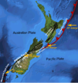
Major active fault zones of New Zealand
-
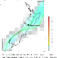
Distribution of earthquakes (magnitude 5 or greater)
See also
- Earthquake Commission
- Geology of New Zealand
- List of tsunamis affecting New Zealand
- Shaky Isles – a nickname for New Zealand
- Volcanism of New Zealand
