List of tsunamis affecting New Zealand facts for kids
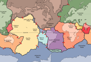
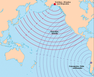
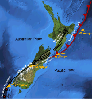
New Zealand often experiences tsunamis because it sits on the edge of the Pacific plate. This area is very active geologically and is part of the "Ring of Fire". Tsunamis are giant ocean waves. They usually happen when there are big earthquakes under the sea. These earthquakes can be close to New Zealand or far away, like near South America, Japan, or Alaska. Sometimes, tsunamis are also caused by underwater landslides, volcanoes, or even meteor impacts.
On average, New Zealand sees at least one tsunami with waves taller than one metre every ten years. We learn about past tsunamis from written records that started in the 1800s. Older events are known through Māori oral stories and scientific studies of ancient tsunami evidence. Scientists are also looking into tsunamis that might happen in large inland lakes, especially from landslides.
Contents
- Major Tsunamis (Waves Over 1 Metre Tall)
- Earthquakes Causing Tsunamis
- Ancient Tsunami (880–800 Years Ago)
- Southland Tsunami (1820s)
- Fiordland Earthquake and Tsunami (1826)
- Wairarapa Earthquake and Tsunami (1855)
- Chile Tsunami (1868)
- Iquique Tsunami (1877)
- Murchison Earthquake Tsunami (1929)
- Napier Earthquake Tsunami (1931)
- Gisborne Tsunamis (1947)
- Chile Tsunami (1960)
- Fiordland Tsunami (2009)
- Chile Tsunami (2010)
- Kaikōura Tsunami (2016)
- Landslides Causing Tsunamis
- Volcanoes Causing Tsunamis
- Meteors Causing Tsunamis
- Tsunamis of Unknown Cause
- Earthquakes Causing Tsunamis
- Smaller Tsunamis (Less Than 1 Metre)
- Tsunami Safety and Warning Systems
- See also
Major Tsunamis (Waves Over 1 Metre Tall)
New Zealand is close to the Pacific Ring of Fire. This means many earthquakes can cause tsunamis here. The biggest tsunamis often come from very powerful earthquakes. These happen in an area called the Hikurangi Margin off New Zealand's east coast.
Earthquakes Causing Tsunamis
Ancient Tsunami (880–800 Years Ago)
Scientists have found signs of a tsunami that hit Big Lagoon, near Blenheim. This happened about 800 to 880 years ago. The waves were at least 3.3 metres high. It was caused by a very large earthquake on the southern Hikurangi Margin.
Southland Tsunami (1820s)
Māori stories tell of a tsunami that killed many Kāti Māmoe people in the 1820s. They were walking along a beach near Orepuki. They had been collecting fish for winter food. The beach was between the sea and cliffs. So, even a 2 to 4-metre high tsunami could have caused many deaths. This tsunami might have come from an earthquake in the Fiordland area. The exact date of this event is not fully confirmed.
Fiordland Earthquake and Tsunami (1826)
In 1826, sealers in Dusky Sound felt a very strong earthquake. It caused many landslides and lifted the land. This earthquake likely had a magnitude of 7.6 to 8. The land movement created a tsunami or a large wave in the sound. The waves were big enough to worry the sealers. They feared their small island would be covered by water. The exact year of this event is also debated by historians.
Wairarapa Earthquake and Tsunami (1855)
On January 23, 1855, a huge earthquake lifted parts of the land. This tilted the Wellington Region and Wellington Harbour. The eastern side of the harbour rose 80 centimetres higher than the western side. This pushed water onto the shore, flooding homes and shops along Lambton Quay.
In Cook Strait, the land moved even more. The Remutaka Range rose about 6 metres. This lifted the seafloor of the strait. The tsunami's exact highest point is unknown. However, sheds 8 metres above sea level at Te Kopi were destroyed. The tsunami affected areas as far north as Otaki and the upper South Island.
About 20 minutes after the earthquake, a 3 to 4-metre high tsunami entered Wellington Harbour. It also swept across the Lyall Bay to Kilbirnie area. The water was about 1 metre deep there. Captain Byron Drury of the ship HMS Pandora saw the effects. He reported that for eight hours, the tide rose and fell every 20 minutes. It rose 2.4 to 3 metres and fell 1.2 metres lower than usual. One ship even ran aground four times.
The earthquake and tsunami also destroyed the bridge over the Hutt River. Ships entering Wellington Harbour later saw many dead fish, mostly ling.
Chile Tsunami (1868)
A powerful earthquake happened near Arica, Chile, on August 13, 1868. The tsunami it created reached New Zealand 15 hours later. It caused a lot of damage on the Chatham Islands and Banks Peninsula. Many places along New Zealand's eastern coast were also affected.
The Chatham Islands were hit first, around 1 am on August 15. A Māori village called Tupuangi was completely destroyed. Luckily, the first wave was small, waking people up so they could get to safety. Later, bigger waves caused the destruction.
At Lyttelton, a night watchman saw a ship nearly touching the jetty. He woke the captain, who noticed Lyttelton Harbour was almost dry. Minutes later, a huge wave rushed into the harbour. It snapped boat ropes and mooring chains. It pushed ships into jetties and each other. The tide kept rising and falling for hours. The tsunami in the harbour was estimated to be 2.5 to 7 metres high.
The tsunami also hit bays around Banks Peninsula. It travelled far inland, damaging homes and carrying away bridges and fences. Several boats were wrecked. At Pigeon Bay, waves up to 2 metres above the highest tide destroyed jetties and carried away timber and fences.
Iquique Tsunami (1877)
On May 10, 1877, a magnitude 8.5 earthquake struck near Iquique, Chile. The tsunami it caused reached New Zealand's eastern coast the next morning. Waves were generally 1 to 2 metres high. They impacted the coast from the Bay of Islands to Bluff. Waves reached 2 to 3 metres high in Akaroa and Gisborne. At Port Charles, they were over 3 metres high.
Because of the 1868 tsunami, newspapers quickly guessed the waves came from a South American earthquake. This was confirmed a few days later when news of the Iquique earthquake arrived.
Murchison Earthquake Tsunami (1929)
On June 17, 1929, a 2.5-metre high tsunami was created by the magnitude 7.8 Murchison earthquake.
Napier Earthquake Tsunami (1931)
The 1931 Hawke's Bay earthquake caused a landslide at Waikare. This landslide then created a local tsunami that was 15.3 metres high. In Napier, the tsunami was about 3 metres high.
Gisborne Tsunamis (1947)
March 26, 1947
On March 26, 1947, a small earthquake was felt in Gisborne. Within 30 minutes, a tsunami hit the coast from Muriwai to Tolaga Bay. It reached a peak height of 10 metres at Turihaua. Four people at a hotel at Tatapouri Point escaped to higher ground. Two waves flooded the hotel's ground floor. Small buildings were washed away. Two men in a cottage at Turihaua were swept inland but survived. The cottage was destroyed. No one was killed. The earthquake that caused this tsunami was about magnitude 7.0-7.1 offshore.
May 17, 1947
On May 17, 1947, another tsunami hit the same coast. It reached a maximum height of 6 metres north of Gisborne. Again, no one was hurt. This tsunami caused less damage because it happened near low tide. The earthquake responsible was about magnitude 6.9-7.1 offshore near Tolaga Bay.
Chile Tsunami (1960)
A massive earthquake in Valdivia, Chile, on May 23, 1960, caused a tsunami. It reached New Zealand early the next morning. Waves were reported at over 120 locations. The eastern coast of New Zealand was affected, from Cape Reinga to Stewart Island. Unusually, the tsunami also reached the west coast of both islands.
At the Chatham Islands and Campbell Island, water levels rose 3 to over 5 metres above sea level. The biggest and most damaging waves usually arrived 12 to 15 hours after the first ones.
The Pacific Tsunami Warning Center warned New Zealand authorities about the approaching tsunami. This led to New Zealand's first major tsunami evacuation. Port areas were cleared, coastal schools closed, and several towns were evacuated.
Fiordland Tsunami (2009)
After an earthquake in Fiordland, tsunami warnings were issued by New Zealand, Australia, and the Pacific Tsunami Warning Center in Hawaii. Civil defence officials in Southland also warned of a "potential tsunami." About fifty people on Lord Howe Island were evacuated. In Sydney, a theatre at Bondi Beach was evacuated.
The tsunami reached 1 metre high in Jackson Bay. It was 25 centimetres at Charleston and 12 centimetres at Dog Island. The tsunami warnings were later cancelled or reduced.
Chile Tsunami (2010)
New Zealand authorities reported wave activity of 50 centimetres in the Chatham Islands. Later, 2-metre surges were reported there. A 2.2-metre high surge hit the South Island's Banks Peninsula. Surges up to 1 metre high were reported in the northern North Island.
Kaikōura Tsunami (2016)
The 2016 Kaikōura earthquake caused a tsunami. It was recorded at 2.5 metres high at Kaikōura. An investigation found the tsunami was 1 metre high at the nearest recording point. At Little Pigeon Bay on Banks Peninsula, the tsunami reached 4.1 metres above sea level. It badly damaged a beachside cottage and travelled 140 metres up a creek.
Landslides Causing Tsunamis
Scientists have found huge underwater landslides near New Zealand's coast. These could have caused large local tsunamis. Researchers have modelled some landslides in the Tasman Sea that happened millions of years ago. They suggest these could have caused 70-metre high tsunamis along the North Island's west coast.
Tolaga Bay Waves (1927–1928)
Between 1927 and 1928, three large waves, over 4 metres high, hit Tolaga Bay. These were possibly caused by landslides.
Doubtful Sound Tsunami (1987)
In May 1987, a 3-metre high local tsunami happened in Deep Cove, Doubtful Sound. It was caused by a landslide into the water.
Charles Sound Tsunami (2003)
During a magnitude 7 earthquake on August 23, 2003, a big landslide fell into Charles Sound. This caused a 4 to 5-metre high tsunami. It damaged a wharf and helipad in the Sound. This tsunami only affected a few hundred metres of coastline. A smaller tsunami, caused by the coast changing shape, was recorded 190 kilometres away at Jackson Bay.
Volcanoes Causing Tsunamis
Taupo Eruption (234 AD)
The Taupo eruption was an inland volcano eruption. However, it created a strong air pressure wave. This wave was powerful enough to cause a tsunami. Evidence of ancient tsunamis in the Cook Strait area might be linked to this event.
Healy Eruption (1360)
There is evidence of a tsunami in the Bay of Plenty from the Healy volcanic eruption.
Krakatoa Eruption (1883)
The 1883 Krakatoa eruption caused a "meteotsunami." This is a tsunami caused by changes in air pressure. It reached up to 2 metres high on the New Zealand coast.
Hunga Tonga Eruption (2022)
On January 16, 2022, a volcanic eruption near Tonga caused a tsunami. Combined with a storm surge from Cyclone Cody, it caused a lot of damage at a marina in Tutukaka, New Zealand. Waves pulled boats from their moorings, sinking some and smashing others. The marina structures were also damaged. Total damage was estimated to be worth millions of dollars.
The tsunami reached Great Barrier Island with a height of 1.33 metres. It caused flooding at Mahinepua Bay, where a campsite was located. All 50 people at the site were safe. People fishing in Hokianga Harbour had to run from the waves. They reported driving through water over 1 metre deep. Unusual waves were also recorded in Port Taranaki in New Plymouth. They lasted 24 hours, with the largest being 1 metre high. No one was hurt in New Zealand.
Meteors Causing Tsunamis
Chicxulub Impact
A giant asteroid hit near the Yucatán Peninsula about 66 million years ago. This impact is thought to have created a global tsunami. It was 30,000 times bigger than tsunamis from recent earthquakes. Scientists believe they have found evidence of this tsunami in rock layers on New Zealand's North and South Islands.
Eltanin Impact
The Eltanin impact was a meteor that hit the eastern South Pacific Ocean about 2.5 million years ago. It is believed to have caused a very large tsunami along New Zealand's coastline.
Mahuika Crater
There are stories and some disputed evidence of a huge tsunami that might have hit Stewart Island in the 1400s. Some people believe this was caused by a meteor impact, possibly creating the Mahuika crater.
Tsunamis of Unknown Cause
East Coast, North Island (200, 800, and 1600 AD)
A study in 2016 looked at Puatai Beach on the East Coast of the North Island. It found signs of three or four large tsunamis. These waves were between 9 and 12 metres high. While they were likely from earthquakes, their exact cause and timing are still being studied.
Western Waikato (1320–1450)
A tsunami event happened sometime between 1320 and 1450. It likely affected 150 kilometres of the Western Waikato coastline. Scientists think it might have been caused by an underwater landslide from the Aotea Seamount. This seamount is about 240 kilometres west of Raglan. Evidence comes from marine gravel found along the coast.
A Māori legend called "Coming of the Sand" from the New Plymouth area describes a possible tsunami. It tells of inland areas being covered by a thick layer of sand.
South Taranaki Bight (1470–1510)
A tsunami that occurred between 1470 and 1510 was linked to the South Taranaki Bight. It may have reached as far south as Abel Tasman National Park. Evidence of this tsunami was found on D'Urville and Kapiti Islands, and at Waitori in South Taranaki.
Māori Settlement Changes (1500s)
During the 1500s, Māori moved their settlements from low coastal areas to inland or hilltop sites. Scientists believe this change was due to tsunamis. Archaeological studies of old coastal settlements show tsunami damage in many places.
D'Urville Island Village (Early 1800s)
Māori oral traditions tell of a large wave that wiped out Moawhitu, a Māori village on D'Urville Island. This event is thought to have happened in the early 1800s and is now believed to have been a tsunami. The exact date is not known.
Chatham Islands Tsunami (1924)
On July 19, 1924, a series of waves hit the northern and eastern sides of Chatham Island and Pitt Island. The waves reached 6 metres above the high-water mark. At Kaingaroa, they travelled 100 metres inland, destroying a dam and two fishing boats. A bridge was damaged, and fences were washed away. On Pitt Island, the wharf was destroyed. The cause of this tsunami is unknown. It could have been from a landslide or an unrecorded earthquake.
Smaller Tsunamis (Less Than 1 Metre)
Many smaller tsunamis have been caused by large earthquakes around the world. For example, the 1923 Kanto earthquake in Japan caused unusual tides in New Zealand. The 1952 Severo-Kurilsk tsunami from Russia reached New Zealand with waves just under 1 metre high.
Tsunami Safety and Warning Systems
Māori people moved their coastal villages inland or to hilltops in the 1500s. This suggests they understood the danger of tsunamis. Early European settlers did not fully realize the risk until the 1868 and 1877 tsunamis.
The first warning systems became available after the 1946 Aleutian earthquake. The National Oceanic and Atmospheric Administration Pacific Tsunami Warning Centre was set up in 1949. New Zealand joined this centre and receives warnings for tsunamis caused by distant earthquakes.
The Pacific Tsunami Warning and Mitigation System was created in 1965. This was after the devastating 1960 Chile tsunami. New Zealand is one of its 46 member countries.
Tsunamis caused by nearby earthquakes can arrive in just a few minutes. This is often not enough time for GeoNet to find the earthquake, decide if it will cause a tsunami, and warn the Ministry of Civil Defence and Emergency Management.
In 2016, Civil Defence took over an hour to warn of a possible tsunami from an earthquake near Te Araroa. This led to calls for better warning systems.
Different regions in New Zealand have different approaches to tsunami warning sirens. For example, Christchurch installed a large siren system in 2012. However, the Wellington region does not have tsunami warning sirens.
New Zealand also did not have sea-based tsunami warning devices during the 2004 Indian Ocean earthquake and tsunami. Since then, gauges have been installed at many coastal sites.
The Pacific Tsunami Warning Centre's ocean-based devices mainly protect Alaska, Hawaii, and the US Pacific coast. This leaves a gap in the Southern Ocean. Australia installed a DART buoy in the south-east Tasman Sea to help cover that area. Now, there are twelve DART buoys in the southwestern Pacific Ocean. They focus on areas like the Hikurangi, Kermadec, Tonga, and Vanuatu trenches. There are no New Zealand DART buoys in the Tasman Sea or south of New Zealand.
Blue Line Project
Wellington was the first city to paint blue lines on its roads. These lines show the limit of where a tsunami could reach. This project won awards for public awareness. It also attracted interest from around the world.
See also
- List of earthquakes in New Zealand
- Tsunami sirens in New Zealand
 | William Lucy |
 | Charles Hayes |
 | Cleveland Robinson |


