2009 Fiordland earthquake facts for kids
 |
|
| UTC time | 2009-07-15 09:22:29 |
|---|---|
| ISC event | 15157724 |
| USGS-ANSS | ComCat |
| Local date | 15 July 2009 |
| Local time | 9:22 pm (NZST) |
| Magnitude | 7.8 Mw |
| Depth | 12 kilometres (7 mi) |
| Epicenter | 45°43′16″S 166°38′35″E / 45.721°S 166.643°E |
| Areas affected | New Zealand |
| Max. intensity | VII (Very strong) MMI |
| Tsunami | 17 cm (6.7 in) |
| Aftershocks | >100 |
| Casualties | 0 |
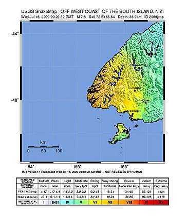
The 2009 Fiordland earthquake was a very strong earthquake. It hit the South Island of New Zealand on July 15, 2009, at 9:22 pm. This earthquake had a magnitude of 7.8. Its center, called the epicenter, was in a faraway area called Fiordland. This spot was about 150 kilometers (93 miles) west-north-west of Invercargill. It was close to Dusky Sound in Fiordland National Park. The earthquake happened about 12 kilometers (7.5 miles) deep underground.
This earthquake was one of the biggest ever recorded in New Zealand. Other large earthquakes include the Culverden/Kaikoura earthquake in 2016 and the 1931 Hawke's Bay earthquake. Both of these also had a magnitude of 7.8.
What Caused the Earthquake?
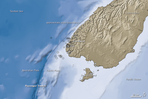
The main earthquake happened because of a "reverse fault" or "thrust fault". This is when one part of the Earth's crust pushes up and over another. In this case, the Indo-Australian plate was sliding under the Pacific Plate. This process is called subduction.
The earthquake caused a large area of land around where it started to lift up. It moved about 1 meter (3 feet) higher.
New Zealand's science group, GNS Science, first said the earthquake was magnitude 6.6. But they later checked and changed it to 7.8.
Scientists said the energy released by this earthquake was huge. It was like 500 million tonnes of TNT. This is 25,000 times stronger than the atomic bomb dropped on Nagasaki in 1945.
The earthquake even twisted New Zealand's South Island. Puysegur Point, at the very bottom of the island, moved 30 centimeters (12 inches) closer to Australia. Te Anau moved 10 centimeters (4 inches). Bluff moved 3 centimeters (1.2 inches), and Dunedin moved 1 centimeter (0.4 inches). Scientists also think it put more stress on the southern part of the Alpine Fault.
Many smaller earthquakes, called aftershocks, happened after the main one.
How Did the Earthquake Affect People and Places?
People felt the earthquake all over the South Island. It was even felt in the lower North Island, as far north as New Plymouth. Luckily, no one was hurt or died because of the earthquake. It only caused small amounts of damage.
Some parts of the South Island lost electricity. Over 200 claims for damage were made to the Earthquake Commission. This is a New Zealand agency that helps people after earthquakes.
Landslides happened in Fiordland National Park near Dusky Sound. These landslides cleared away large areas of trees.
Tsunami Warning
Soon after the earthquake, warnings for a tsunami were sent out. These warnings came from officials in New Zealand and Australia. The Pacific Tsunami Warning Center in Hawaii also sent out a warning.
Civil defense officials in Southland also warned about a "potential tsunami." They were worried because the earthquake's size was measured differently by various groups.
Because of the warnings, about fifty people on Lord Howe Island had to leave their homes. In Sydney, a theater at Bondi Beach was emptied. People living near the coast were told to stay away from the shore.
In the end, the waves along New Zealand's western coast were about one meter (3 feet) high from peak to trough. This was in the Haast area. The actual height of the water rise was 17 centimeters (6.7 inches). The tsunami warnings were later canceled or lowered.
 | Aaron Henry |
 | T. R. M. Howard |
 | Jesse Jackson |


