
2010 Chile earthquake facts for kids

Damage sustained by a building in Concepción, located around 100 kilometres south of the epicenter.
|
|
 |
|
| UTC time | 2010-02-27 06:34:12 |
|---|---|
| ISC event | 14340585 |
| USGS-ANSS | ComCat |
| Local date | 27 February 2010 |
| Local time | 03:34:12 CST (UTC-03:00) |
| Duration | 3 minutes |
| Magnitude | 8.8 Mww |
| Depth | 35 km (22 mi) 30.1 km (19 mi) |
| Epicenter | 35°54′32″S 72°43′59″W / 35.909°S 72.733°W 36°17′24″S 73°14′20″W / 36.290°S 73.239°W |
| Type | Megathrust |
| Areas affected | Chile |
| Max. intensity | IX (Violent) |
| Peak acceleration | 0.65 g |
| Tsunami | 24.1 m (79 ft) |
| Casualties | 525 dead, 25 missing |

The 2010 Chile earthquake and tsunami was a very powerful natural disaster that happened off the coast of central Chile on February 27, 2010. It struck at 3:34 AM local time and had a magnitude of 8.8, making it one of the strongest earthquakes ever recorded. The ground shook intensely for about three minutes. Many cities in Chile felt the earthquake strongly, especially Concepción, Arauco, and Coronel. Even the capital city, Santiago, experienced very strong shaking. Tremors were felt in other countries like Argentina and Peru.
This earthquake also caused a huge tsunami (a series of ocean waves caused by large-scale disturbances). The tsunami hit several coastal towns in south-central Chile and damaged the port of Talcahuano. Warnings for the tsunami were sent to 53 countries around the Pacific Ocean. The earthquake also caused a massive power outage, affecting 93% of Chile's population. The President of Chile at the time, Michelle Bachelet, declared a "state of catastrophe" and sent military troops to help the affected areas. Sadly, 525 people lost their lives, 25 went missing, and about 9% of the people in the affected regions lost their homes. The cost to rebuild and recover from this event was estimated to be billions of dollars.
Contents
The Great Chile Earthquake of 2010
Where the Earthquake Happened
The earthquake's starting point, called the epicenter, was about 3 kilometers (1.9 miles) off the coast of Pelluhue in the Maule Region. This area is about 100 kilometers (62 miles) from several provincial capitals like Talca and Concepción. Chile's own experts placed the epicenter slightly differently, about 34 kilometers (21 miles) off the coast of the Ñuble Region.
How Earthquakes Work in Chile
This earthquake happened because of how the Earth's giant plates, called tectonic plates, move. Chile sits where the Nazca plate is sliding underneath the South American plate. This process is called subduction, and it often causes very strong earthquakes. The plates move towards each other at about 80 millimeters (3.1 inches) per year. Over time, a lot of stress builds up, and when it releases, it causes a powerful earthquake like the one in 2010. Chile has a long history of these "megathrust" earthquakes, including the strongest one ever measured in 1960.
Scientists believe that the part of the fault that broke during this earthquake was over 700 kilometers (430 miles) long. The movement was so strong that it shifted the entire South American plate to the west. For example, Santiago moved about 28 centimeters (11 inches) to the west-southwest, and Concepción moved at least 3 meters (9.8 feet) to the west! Even Buenos Aires, Argentina, moved about 2.5 centimeters (1 inch). Some coastal areas were even lifted higher by up to 3 meters (9.8 feet).
Comparing with Other Big Earthquakes
The 2010 Chile earthquake was the strongest earthquake to hit Chile since the massive 9.5 magnitude 1960 Valdivia earthquake. It was also one of the strongest earthquakes worldwide since the 2004 Indian Ocean earthquake and tsunami and until the 2011 Tōhoku earthquake and tsunami. It was about 500 times more powerful than the 7.0 magnitude earthquake that struck Haiti just one month earlier in January 2010.
Aftershocks: Smaller Tremors That Follow
After a big earthquake, many smaller earthquakes, called aftershocks, usually follow. Just 20 minutes after the main quake, a 6.2 magnitude aftershock was recorded. Many more followed, with over 130 aftershocks registered within a week, including thirteen that were stronger than magnitude 6.0. Scientists set up special equipment to study these aftershocks, and they recorded 20,000 of them in the six months after the main earthquake. These smaller quakes helped them understand more about the Earth's structure in that area. Even in 2011, more than a year later, significant aftershocks, like a 7.1 magnitude tremor, continued to occur.
How the Earthquake Changed the Earth
Scientists have made some amazing discoveries about how this earthquake affected our planet. They estimate that it was so powerful it actually shortened the length of an Earth day by 1.26 microseconds! It also shifted the Earth's axis by about 8 centimeters (3 inches). Precise GPS measurements showed that the city of Concepción moved 3.04 meters (10 feet) to the west. The capital, Santiago, shifted almost 24 centimeters (9.4 inches) west, and even Buenos Aires, Argentina, moved 4 centimeters (1.6 inches). It's thought that Chile's land area might have expanded by about 1.2 square kilometers (0.46 square miles) because of this earthquake. The earthquake even caused small waves, called seiches, in Lake Pontchartrain in the United States, nearly 7,500 kilometers (4,660 miles) away!
What Happened and Who Was Affected
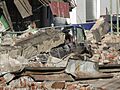
The earthquake caused widespread damage across Chile. Many buildings collapsed, especially in cities like Santiago and Concepción. Power outages were common, and a fire broke out at a chemical plant near Santiago, requiring people to evacuate. Santiago's international airport was damaged and closed for a day. Hospitals also suffered significant damage, with some collapsing and many others becoming unsafe.
In Valparaíso, a tsunami wave of 1.29 meters (4.2 feet) was reported, and the port had to close. Many cities in the Maule Region were severely affected, with over 1,000 landslides occurring. The town of Curanipe, very close to the epicenter, was hit by a tsunami and cut off from outside help. In Talca, the capital of Maule, many people were trapped in collapsed buildings, and the local hospital was mostly in ruins.
Concepción saw extensive damage, and rescue teams struggled to reach the city due to damaged roads. A 15-story residential building completely toppled over, trapping many residents. The port city of Talcahuano was hit by a 2.34-meter (7.7-foot) tsunami wave, which severely damaged port facilities and moved boats far inland. Even in Temuco, about 400 kilometers (250 miles) from the epicenter, buildings were damaged, and cars were crushed by falling debris.
The earthquake and tsunami damaged 370,000 homes across Chile. The final count of victims was 525 people who died and 25 who were missing.
Homes Damaged or Destroyed
The earthquake and tsunami caused significant damage to homes across the affected regions. In the Maule Region, over 20% of the population had their homes destroyed or severely damaged. The Biobío Region also saw high numbers, with nearly 18% of homes affected. Overall, about 8.8% of the population in the six most affected regions lost their homes or had them badly damaged.
Life After the Earthquake
Challenges and Helping Hands
After the earthquake, nearly half of Chile was declared a "catastrophe zone." Some areas faced challenges with public order. There were instances where people took items from stores, leading to curfews and the deployment of military troops to help restore calm. Authorities worked to regain control and provide assistance. Many Chileans, both within the country and abroad, were worried about their loved ones in the hardest-hit areas, where communication was difficult due to power and phone line failures.
In Concepción, a prison riot broke out after an escape attempt. Guards had to use force and military help to bring the situation under control. In another prison in Chillán, 203 prisoners escaped, and 36 were later recaptured. These events added to the challenges faced by the authorities during the emergency.
Getting the Economy Back on Track
Chile quickly began to recover economically. Within a few days, the central port of San Antonio was operating at 80% capacity, and the port of Valparaíso was back to normal. However, ports closer to the epicenter in southern Chile remained closed for longer. President Bachelet stated that Chile would need international help and several years to fully rebuild. Insurance companies estimated the cost to the industry to be between 4 and 7 billion dollars.
Food and Supplies
Concerns arose about food supplies, but authorities assured that prices for milk and wheat would not rise significantly. However, some reports indicated unjustified price increases for flour. The earthquake also affected beer production, causing temporary shortages and price increases, but companies worked to normalize production and import beer from Argentina.
The Tsunami's Journey Across the Pacific
The earthquake generated a massive tsunami that traveled across the entire Pacific Ocean. A tsunami warning was first issued for Chile and Peru, then expanded to cover almost all coastal areas on the Pacific. This meant that people in many countries, from Ecuador to Japan, had to prepare for incoming waves.
Scientists used special buoys in the deep ocean to measure the tsunami waves. Even though the waves might seem small in the deep ocean (like 25 centimeters or 9.8 inches), they become much taller and more powerful as they approach shallow coastal areas.
Tsunami in Chile
About 30 minutes after the earthquake, the tsunami hit Chile's coast. Constitución was one of the hardest-hit towns, with waves reaching up to 24.1 meters (79 feet) high and causing about 350 deaths. Valparaíso recorded waves up to 2.6 meters (8.5 feet), and Talcahuano saw waves of 2.34 meters (7.7 feet). Robinson Crusoe Island, far off the coast, was also struck by a large wave, leading to four deaths and eleven people missing.
There was some debate about whether the Chilean Navy issued tsunami warnings quickly enough. However, port captains did sound alarms, which helped save some lives.
Tsunami Around the Pacific
The tsunami traveled far beyond Chile.
- New Zealand: Waves up to 2.2 meters (7.2 feet) high hit the South Island's Banks Peninsula.
- Antarctica: The Palmer Station went on alert, and small waves of several centimeters were recorded.
- Australia: Tsunami warnings were issued, and waves between 10 and 50 centimeters (3.9 and 19.7 inches) were recorded, causing strong currents.
- French Polynesia: Waves up to 1.8 meters (5.9 feet) struck some areas, with a 4-meter (13-foot) wave reported in Hiva Oa.
- American Samoa: Still recovering from a 2009 tsunami, residents were urged to move to higher ground.
- Philippines: An alert was issued for eastern coastal areas, but later canceled as waves were small.
- Hawaii: Warning sirens sounded, and tourists were evacuated. Waves reached about 1.5-1.8 meters (4.9-5.9 feet) peak to trough.
- North America: Coastal British Columbia, California, and Oregon were under advisories. Small waves caused minor damage in California, like to navigation buoys. In Guerrero, Mexico, surges of up to 1 meter (3.3 feet) were reported, and three small boats sank.
Tsunami Data: How Big Were the Waves?
Here's a look at some of the tsunami wave heights recorded in different places:
| Station | Country or territory | Latitude | Longitude | Time (UTC) | Height (m) | Height (ft) |
|---|---|---|---|---|---|---|
| Pichilemu | 34.23 S | 72.0 W | 06:48 | 3.02 | 10.0 | |
| Talcahuano | 36.9 S | 75.4 W | 06:53 | 2.34 | 7.7 | |
| Valparaíso | 33 S | 71.6 W | 07:08 | 1.29 | 4.2 | |
| Corral | 39.9 S | 73.4 W | 07:39 | 0.90 | 2.9 | |
| Easter Island | 27.2 S | 109.5 W | 12:05 | 0.35 | 1.1 | |
| Manzanillo | 19.1 N | 104.3 W | 17:05 | 0.32 | 1.0 | |
| Hiva Oa | 9.8 S | 139.0 W | 17:41 | 1.79 | 5.9 | |
| Acapulco | 16.8 N | 99.9 W | 19:31 | 0.62 | 2.0 | |
| Hilo, Hawaii | 19.7 N | 154.9 W | 21:20 | 0.86 | 2.8 | |
| Kahului, Hawaii | 20.9 N | 156.5 W | 21:47 | 0.98 | 3.2 | |
| Otsuchi, Iwate | 39.21 N | 141.54 E | 06:43 | 1.45 | 4.35 | |
| Yamada, Iwate | 39.47 N | 141.95 E | 08:14 | 1.61 | 4.85 |
Images for kids
-
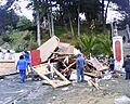
House thrown into the streets of Pelluhue after the tsunami
-
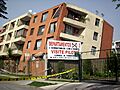
A severely damaged building in Maipú, Santiago
-
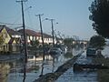
Tsunami in Talcahuano, Biobío Region
-
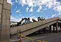
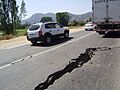
Collapsed Vespucio Norte Express Highway in Santiago
-
Fruit Road, O'Higgins Region
-
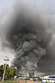
Fire at a plastics plant, Santiago, Chile.
-
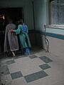
Hernán Henríquez Hospital of Temuco had to be evacuated after the earthquake.
-
A car crushed by the rubble of a collapsed building in Temuco.
-
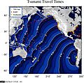
Tsunami ETA NOAA (hour 0=06:34 UTC 27 Feb)
-
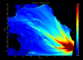
The energy model map of the tsunami.
-
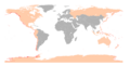
Countries with coastal areas that were at risk (in pink).
-
Geographic distribution of the death toll (red: caused by the earthquake; blue: caused by the tsunami).
-
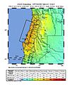
USGS shake map of the earthquake.
-
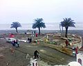
Kiosks destroyed by the tsunami in Pichilemu.
-
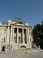
The damaged Museum of Fine Arts.
-
Agustín Ross balcony damaged after the earthquake and tsunami in Pichilemu.
-
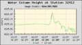
The tsunami's passage as recorded by National Data Buoy Center Deep-ocean Assessment and Reporting of Tsunamis (DART) buoy 34142, located in the southeastern Pacific Ocean 630 nautical miles (1170 km) southwest of Lima, Peru.


.jpg)


See also
- 2010 Chile blackout
- 2010 Haiti earthquake
- Geology of Chilea
- List of earthquakes in Chile
- Lists of earthquakes
