
Pelluhue facts for kids
Quick facts for kids
Pelluhue
|
|||||
|---|---|---|---|---|---|
|
Town and Commune
|
|||||
|
|||||
| Country | Chile | ||||
| Region | Maule | ||||
| Province | Cauquenes | ||||
| Government | |||||
| • Type | Municipality | ||||
| Area | |||||
| • Total | 371.4 km2 (143.4 sq mi) | ||||
| Elevation | 11 m (36 ft) | ||||
| Population
(2012 Census)
|
|||||
| • Total | 6,620 | ||||
| • Density | 17.824/km2 (46.17/sq mi) | ||||
| • Urban | 6,414 | ||||
| • Rural | 3,877 | ||||
| Demonym(s) | Pelluhuano | ||||
| Sex | |||||
| • Men | 3,408 | ||||
| • Women | 3,006 | ||||
| Time zone | UTC-4 (CLT) | ||||
| • Summer (DST) | UTC-3 (CLST) | ||||
| Postal code |
3710000
|
||||
| Area code(s) | 56 + 73 | ||||


Pelluhue is a town and a commune located in the Cauquenes Province of central Chile. Its name comes from the Mapudungun language and means land of clams. It is part of Chile's seventh region, called Maule.
Contents
Geography of Pelluhue
The commune of Pelluhue covers an area of about 371.4 square kilometers (143.4 square miles). It shares its northern border with Chanco and its southern border with Cobquecura in the Ñuble Region. To the east, it borders Cauquenes, and to the west, it meets the Pacific Ocean. The main office for the commune is in the town of Curanipe.
People of Pelluhue
Even though Curanipe is the official center for the commune, Pelluhue actually has more people living there. This includes both people who live there all the time and those who visit for holidays. In 2002, a study showed that Pelluhue had 6,414 residents. Out of these, 3,877 people lived in urban areas (towns), and 2,537 lived in rural areas (the countryside).
Pelluhue has become a popular place for tourism and for people to retire. Because of this, its population has grown a lot over the last 20 years. Between 1992 and 2002, the number of people living in Pelluhue increased by 17.2%.
History of Pelluhue
Both Pelluhue and Curanipe are now popular places for holidays by the sea. Pelluhue started as a small fishermen's cove (a small bay). In less than 50 years, it grew into a busy seaside resort where many people spend their summers. During summer weekends, thousands of vacationers from nearby cities like Cauquenes, Linares, Talca, and Parral come to visit the seaside.
Curanipe has a longer history as a well-known coastal resort. It was a popular and quiet spot for important families from Cauquenes in the late 1800s and early 1900s. It was also a small but important port. Both Pelluhue and Curanipe were part of the municipality of Chanco until 1979. The commune of Pelluhue was officially created on October 26, 1979. At that time, Pelluhue and Curanipe, along with their surrounding areas, became a new municipality.
The Santo Toribio parish church in Curanipe is an old religious building that looks over the town. Pelluhue is part of the Curanipe Parish, which belongs to the Diocese of Linares in Chile.
How Pelluhue is Governed
Pelluhue is a commune, which means it's like a local government area. It is managed by a municipal council. The head of this council is an alcalde (mayor), who is chosen directly by the people every four years. The mayor from 2008 to 2012 was Carlos Zúñiga Villaseñor.
Fun Things to Do and See

In the southernmost part of the municipality, close to the Bío Bío Region, you can find the quiet beach of Tregualemu. Near this beach, there are two old, large country houses built in the traditional Chilean colonial style.
The Los Ruiles National Reserve is a nature reserve located on the eastern side of Pelluhue. It is in the foothills of the Chilean Coast Range (Cordillera de la Costa). This reserve is like a small green space next to the road that connects Chanco and Cauquenes. It is home to many native species of trees and plants. Some of these plants are only found in this region, and a few are even in danger of extinction. The reserve covers 29 hectares (about 71 acres) and has a reception area, picnic tables, and two walking paths.
The 2010 Earthquake
On February 27, 2010, Pelluhue and Curanipe were badly damaged by a very strong earthquake. The earthquake measured 8.8 on the moment magnitude scale. After the earthquake, a tsunami (a giant ocean wave) hit the coast. The tsunami pushed 60-foot fishing boats into the streets. The towns were covered in mud, and hundreds of homes were completely destroyed. Many people lost their lives, and about 300 homes in Pelluhue alone were ruined. The commune of Pelluhue is very close to the town of Cobquecura, which was the center of the earthquake.
Images for kids
-
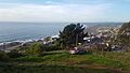
Pelluhue, a beautiful coastal town.
-
The beautiful coast of Pelluhue.
See also
 In Spanish: Pelluhue para niños
