Ōtara facts for kids
Quick facts for kids
Ōtara
|
|
|---|---|
|
Suburb
|
|
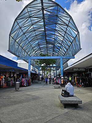
The central section of Fish Canopy, a 1987 sculpture in the Ōtara Town Centre
|
|
| Country | New Zealand |
| Local authority | Auckland |
| Electoral ward | Manukau ward |
| Local board | Ōtara-Papatoetoe Local Board |
| Area | |
| • Land | 680 ha (1,680 acre) |
| Population
(June 2023)
|
|
| • Total | 24,520 |
|
|
||
Ōtara is a lively suburb in South Auckland, New Zealand. It's located about 18 kilometres southeast of the main Auckland City Centre. The area is close to the Tamaki River.
The name Ōtara comes from Ōtara Hill / Te Puke ō Tara. This was once a Ngāi Tai ki Tāmaki pā (a fortified village) and a volcanic hill. For many years, Ōtara was a large farm. Later, it became an agricultural college. In the 1950s, after a major motorway was built, Ōtara grew into a modern suburb. Many homes were built here as part of a government housing plan.
Contents
What's in a Name? The Meaning of Ōtara
The name Ōtara means "The Place of Tara." It's a shorter version of Ōtara Hill / Te Puke ō Tara. This volcanic hill used to be just north of the suburb.
The name Tara might come from two different sources. It could be from Tara-mai-nuku, an old Waiohua ancestor and a taniwha (a mythical water creature). Or, it could be named after Tara Te Irirangi, a important chief of Ngāi Tai ki Tāmaki in the 1800s.
Long ago, the area was also called Ngā Kopi o Toi. This means 'The Karaka Berries of Toi'. It referred to a grove of karaka trees. These trees were said to have been brought from the Chatham Islands by a person named Toi-te-huatahi.
Exploring Ōtara's Landscape
Ōtara is located in South Auckland, near the southeastern part of the Tāmaki River. It's mostly northeast of the Auckland Southern Motorway. The Ōtara Creek flows through the suburb. In the north, it becomes a tidal estuary of the Tāmaki River.
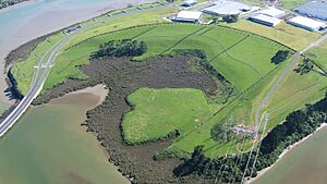
The area also has two interesting volcanic features. Pukewairiki is a volcanic maar. This is a wide, flat-bottomed crater that formed when a volcano erupted a long time ago. It's part of the Ōtara Creek estuary.
Ōtara Hill / Te Puke o Tara is another volcano. It's located north of Ōtara in East Tāmaki. This hill was used as a quarry in the mid-1900s. Lava from this hill once flowed as far south as the Ōtara Town Centre.
Ōtara's Weather
Ōtara has a mild climate. The warmest month is February, with an average temperature of 19.3°C. The coolest month is July, with an average of 9.9°C. The highest temperature ever recorded was 30.0°C in February. The lowest was -4.1°C in July. Ōtara receives a good amount of rain throughout the year, with June being the wettest month.
A Look Back: Ōtara's History
Māori History and Early Life

The Ōtara area is part of the traditional lands of Ngāi Tai ki Tāmaki. These people are descendants of the Tainui canoe crew, who arrived around 1300. The mouth of the Tāmaki River was known as Te Wai ō Tāiki. This name comes from the Ngāi Tai ancestor Tāiki.
The upper parts of the river were called Te Wai Mokoia. This refers to Mokoikahikuwaru, a special taniwha from the Tainui canoe stories. Ōtara is also near important portages. These were places where waka (canoes) could be easily carried over land. This allowed travel between the Manukau Harbour and the Tāmaki River.
Ngāi Tai people grew many crops along the Tāmaki River's eastern banks. The area around Ōtara Creek and Ōtara Hill / Te Puke ō Tara had large stonefield gardens. There was also a fortified pā here. Over time, Ngāi Tai people living in Ōtara formed close ties with other tribes. These included Te Akitai, Ngāti Tamaoho, and Ngāti Kahu. They also connected with people from the Hauraki Gulf, like Ngāti Pāoa. Today, Ngāi Tai still have special rights and connections to the Ōtara area.
During the Musket Wars in the 1820s, Ngāi Tai found safety in the Waikato region for a while. When a missionary named William Thomas Fairburn visited in 1833, the area was mostly empty.
In 1836, Fairburn arranged a land sale with Māori chiefs. This sale covered most of what is now South Auckland and East Auckland. The idea was to stop fighting in the area. However, it's not clear if the chiefs fully understood or agreed to the sale. Māori people continued to live in the area as before. Later, in 1854, a special reserve for Ngāi Tai was created near the Wairoa River. As part of this agreement, Ngāi Tai members moved from their western settlements.
European Settlement and Growth
In 1851, William Goodfellow bought Otara Farm. He built a home along the Tāmaki River. Another settler, Reverend Gideon Smales, bought land in East Tāmaki in 1856. The wider East Tāmaki area was mostly farmland, growing crops like wheat. Later, it changed to dairy farms.
In 1861, Governor George Grey ordered the building of the Great South Road. This road went further south into the Waikato region. It helped supply troops during the Invasion of the Waikato. In 1863, Governor Grey told all Māori in South Auckland to promise loyalty to the Queen and give up their weapons. Most refused and moved south. After the war, the Crown took a lot of Māori land, including land in South Auckland and East Auckland. This happened even though Ngāi Tai were considered "friendly" by the Crown.
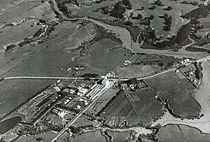
In 1910, the Goodfellow family sold their farm to the Dilworth Trust. They started an agricultural school there in 1915. Not many students attended, and the school closed in 1918. In 1919, the Dilworth Trust divided the land. In 1950, they sold much of it to the Ministry of Works. This ministry set up the Otara Fertiliser Research Station where the school used to be. In 1929, the Waitemata Brewery was built. It later became DB Breweries.
Ōtara's Modern Development
The building of the Auckland Southern Motorway in the mid-1950s led to a big increase in population. To help with crowded central suburbs, the New Zealand Government started building large state housing areas. Ōtara was chosen because it was close to the motorway and industrial areas. It was one of the first big state housing projects in Auckland for families with lower incomes.
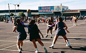
In 1958, New Zealand's first supermarket, Otahuhu Foodtown, opened in Ōtara. The Ōtara Town Centre officially opened in 1966.
In 1968, the Otahuhu Power Station opened in Ōtara. It was the largest gas turbine power station in Australia and New Zealand at the time. It operated until 2016. In 1970, the Otara Fertiliser Research Station became the Ōtara campus of Manukau Institute of Technology. In 1972, the Ngāti Ōtara Marae officially opened. In 1987, the Ōtara Town Centre was updated. The sculpture Fish Canopy by architect Rewi Thompson was added. It looks like a fish and is inspired by Pacific Island fale (traditional houses).
Who Lives in Ōtara?
Ōtara covers about 6.80 square kilometres. As of 2023, it has an estimated population of around 24,000 people. This means there are about 3,500 people living in each square kilometre.
In 2018, the population was 22,872. This was an increase of over 2,000 people since 2013. About 30% of the people in Ōtara are under 15 years old.
Ōtara is a very diverse suburb. Many people identify as Pacific peoples (78.0%) and Māori (21.9%). There are also people of European and Asian backgrounds. About 34% of the people in Ōtara were born overseas.
Most people in Ōtara identify as Christian. A smaller number have Māori religious beliefs or other religions.
Interesting Places in Ōtara
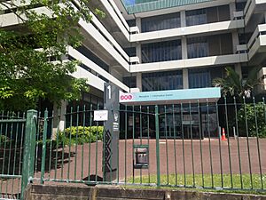
- The D.S.I.R buildings are on Otara Road. They were built in 1916 and bought by the D.S.I.R in 1950.
Famous Faces from Ōtara
Ōtara has been home to many notable people:
- Len Brown: The first Mayor of the Auckland "Super City".
- Pauly Fuemana: A musician from the band OMC, famous for the song "How Bizarre".
- Tau Henare: A politician who was the 38th Minister for Māori Affairs.
- Sid Diamond and Deach: Hip-hop artists and members of the group Smashproof.
- Manu Vatuvei: A rugby league player known as "The Beast" who played for the Vodafone Warriors and the Kiwis.
- Tina Cross: A well-known entertainer.
- Rawiri Paratene: An actor.
- Beulah Koale: An actor.
- Nailini Helu: Known as "The Tongan Goddess," she was the world's first Tongan female professional boxer.
- Efeso Collins: A politician who served on Auckland Council and later as a Member of Parliament.
Ōtara's Culture and Community
Ōtara gained some worldwide fame because of the hit song "How Bizarre" by the hip-hop group OMC. The letters "OMC" stand for "Otara Millionaires' Club."
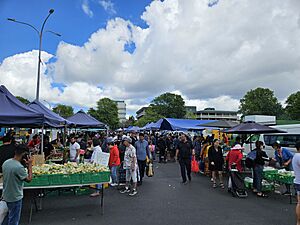
Ōtara is also famous for its Saturday morning 'flea market'. This market is held in the Ōtara shopping centre car park. It started in the late 1970s and is the largest street market in New Zealand. It's a great place to find unique items and experience the local culture.
In the past, Ōtara had higher crime rates. However, efforts by the police and community have helped reduce crime. More police in the area and a focus on working with the community have made a positive difference. This has also helped build better relationships between locals and the police.
Learning in Ōtara: Schools and Education
Ōtara has many schools for different age groups.
- Sir Edmund Hillary Collegiate is a unique school with three parts on one campus.
- The Junior School is for years 1–6.
- The Middle School is for years 7 and 8.
- The Senior School is for years 9–13.
- Tangaroa College is a secondary school for years 9–13. It also has a special unit for teen parents.
- Ferguson Intermediate is an intermediate school for years 7–8.
- There are several primary schools for years 1–6, including Bairds Mainfreight Primary School, Dawson School, East Tāmaki School, Flat Bush School, Mayfield School, Rongomai School, Wymondley Road School, and Yendarra School.
- Te Kura Kaupapa Māori o Otara is a primary school where students learn in the Māori language.
- St John the Evangelist Catholic School is a primary school with a Catholic focus.
All these schools are coeducational, meaning both boys and girls attend. Ōtara is also home to the main campuses of Manukau Institute of Technology. This institute offers many different courses for higher education.
 | Kyle Baker |
 | Joseph Yoakum |
 | Laura Wheeler Waring |
 | Henry Ossawa Tanner |


