
Ōita Prefecture facts for kids
Quick facts for kids Ōita Prefecture |
|||||||||
|
|||||||||
 |
|||||||||
| Capital | Ōita | ||||||||
| Region | Kyūshū | ||||||||
| Island | Kyūshū | ||||||||
| Governor | Katsusada Hirose | ||||||||
| Area (rank) | 6,338.82 km² (24th) | ||||||||
| - % water | 0.7% | ||||||||
| Population (Oct 1, 2005) | |||||||||
| - Population | 1,209,587 (34th) | ||||||||
| - Density | 191 /km² | ||||||||
| Districts | 3 | ||||||||
| Municipalities | 18 | ||||||||
| ISO 3166-2 | JP-44 | ||||||||
| Website | www.pref.oita.jp/english/ | ||||||||
| Prefectural Symbols | |||||||||
| - Flower | Bungo-ume blossom (Prunus mume var. bungo) | ||||||||
| - Tree | Bungo-ume tree (Prunus mume var. bungo) | ||||||||
| - Bird | Japanese white-eye (Zosterops japonica) | ||||||||
| - Fish | |||||||||
 Symbol of Ōita Prefecture |
|||||||||

Ōita Prefecture (大分県, Ōita-ken) is a special area in Japan. It is located in the Kyūshū region, on the island of Kyūshū. The main city, or capital, is Ōita. This prefecture is famous for its many hot springs, which are natural warm water pools.
Contents
A Look Back in Time
Long ago, around the 6th century, the Kyūshū area was split. It became two different regions: Bungo Province and Buzen Province.
Later, after a big change in Japan called the Meiji Restoration, parts of these old provinces joined together. This is how Ōita Prefecture was formed.
Important Dates
- 1184: Usa Shrine was burned down during the Gempei War.
- November 19, 1274: The Battle of Bun'ei took place.
- August 15, 1281: The Battle of Kōan happened.
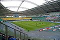
- 2002: Ōita was one of the cities that hosted games for the FIFA World Cup.
Where Ōita Is Located
Ōita Prefecture is found on the northeastern part of the Kyūshū island.
To the north, Ōita faces the Suo Channel and Honshū Island. To the east, it looks out over the Iyo Channel and Shikoku Island. Miyazaki Prefecture is to its south. On the west, Ōita shares borders with Fukuoka Prefecture and Kumamoto Prefecture.
Cities in Ōita
Ōita Prefecture has many cities. Here are some of them:
- Beppu
- Bungo-ōno
- Bungotakada
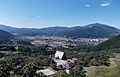
- Hita
- Kitsuki
- Kunisaki
- Nakatsu
- Ōita (This is the capital city!)
- Saiki
- Taketa
- Tsukumi
- Usa
- Usuki
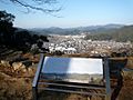
- Yufu
Towns and Villages
Ōita also has smaller towns and villages, grouped into districts:
- Hayami District:
- Hiji
- Higashikunisaki District:
- Himeshima
- Kusu District:
- Kokonoe
- Kusu
Natural Parks
About 28% of Ōita Prefecture's total land area is protected as national parks. These parks help keep nature safe.
Important Shrines and Temples
Ōita is home to several important religious sites.
- Sasamuta-jinja, Usa-jinjū, and Yusuhara Hachiman-gū are the main Shinto shrines in the prefecture.
- Fukiji Temple has the oldest wooden building on the island of Kyūshū.
- The Usuki Buddhas are more than 60 carvings of Buddha figures. They are carved into cliffs and date back to the Heian period.
See also
 In Spanish: Prefectura de Ōita para niños
- Provinces of Japan
- Prefectures of Japan
- List of regions of Japan
- List of islands of Japan
- Oita Trinita
Images for kids
-
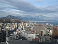
Ōita City
-

Hita
-
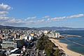
Beppu
-
Yufu
-
Saiki
-
Showa Denko Dome Oita.


