
2009 Red River flood facts for kids

Red River of the North in Fargo, March 28, 2009
|
|
| Date | March 2009–April 2009 |
|---|---|
| Location | North Dakota, Minnesota, Manitoba |
| Deaths | 3 |
| Property damage | Unknown |
The 2009 Red River flood was a big flood along the Red River of the North. It affected parts of North Dakota and Minnesota in the United States, and Manitoba in Canada. The flood brought record-high water levels to the Fargo-Moorhead area. This flood happened because the ground was already soaked and frozen. Then, a lot of snow melted quickly, and there were extra rain and snow storms. Also, the land around the river is very flat, which makes flooding worse. People living along the Red River had about a week to get ready. The U.S. National Weather Service kept giving updates, predicting higher and higher water levels for Fargo, North Dakota. The river was expected to reach about 43 feet (13 meters) by March 29. But it actually peaked a bit lower, at 40.84 feet (12.45 meters), on March 28 and then slowly started to go down. The water continued to rise further north as the flood moved downstream.
Contents
Why the Red River Flooded
River's Path and Land
The Red River flows from the United States north into Lake Winnipeg in Manitoba, Canada. Because it flows north, it goes into colder areas. This means that melting snow and river ice, along with water from smaller rivers joining it, can often create "ice jams." These jams block the river and make it overflow. The land in the valley is very flat. This causes water to spread out widely, leading to large areas of flooding with no high ground for safety.
-
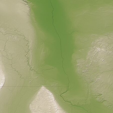
The Red River flood plain. Green areas are low, while tan and white areas are higher.
-
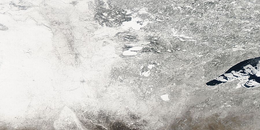
The Red River around Fargo before the 2009 floods began, seen from space.
-
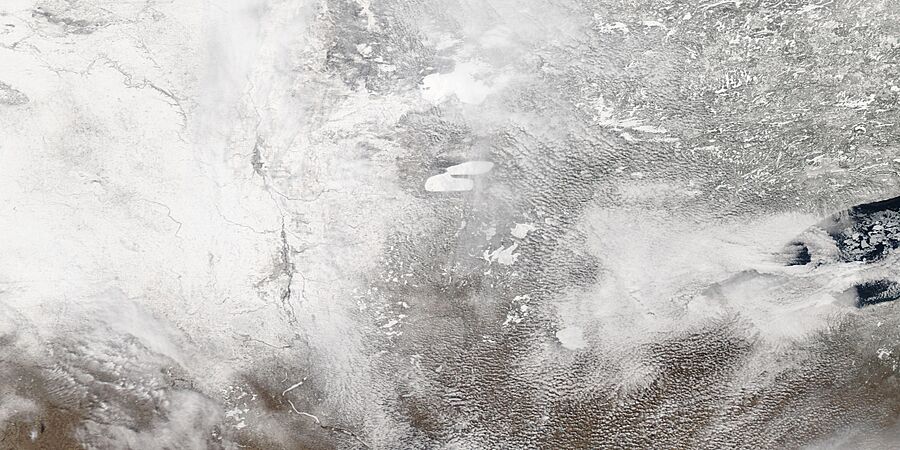
The flooded river around Fargo as seen from space.

.jpg)
.jpg)
Weather Conditions
The ground was already very wet when winter started and then froze solid. When the snow melted, the frozen ground couldn't soak up the water. There was also a lot of snow during the winter. A rainstorm hit on March 22, and another snowstorm followed. All these factors, plus the fast melting of snow due to warmer temperatures, led to the severe flooding.
A low-pressure weather system caused the rainstorm on March 22. By March 25, the Winnipeg area received 6 to 10 inches (15 to 25 cm) of snow. Southern Manitoba got even more, with 8 to 12 inches (20 to 30 cm). In northeastern North Dakota and northwestern Minnesota, about 8 inches (20 cm) of snow fell from the same storm.
Getting Ready for the Flood
Fargo-Moorhead Area Preparations


Warnings for the 2009 flood started early, on March 9. The National Weather Service said that the Fargo-Moorhead area could see a big flood. North Dakota Governor John Hoeven declared a statewide disaster on March 16. This was to prepare for flooding across the state. On March 19, the predicted flood level for Fargo was raised.
The city started filling sandbags on March 20. By March 22, volunteers had filled 560,000 sandbags. They expected to need 1.5 million to 2 million in total. By March 24, people in Fargo-Moorhead had filled over 1 million sandbags. They aimed for 2 million by March 26.
Emergency dikes were built in Fargo, Moorhead, and other nearby towns. These dikes needed a lot of clay. Clay was brought from places like a soccer field and near a middle school.

Manitoba's Flood Fight
.jpg)
In Manitoba, the 2009 flood was the second worst recorded since 1826. The Red River Floodway was not opened right away. This was because the river was full of ice, which could damage the floodway. The floodway was opened in early April once the ice cleared. Several towns declared a state of emergency because of ice jams.
The floodway opened on April 8 as a flood crest was expected to hit Winnipeg. Highway 75, a main road between Winnipeg and the U.S. border, was closed for over a month. This closure cost trucking companies a lot of money and hurt the economy of Morris.
Sadly, three people died during the flood. An eight-year-old boy, Samuel Gross, fell into the river but was rescued and recovered after being in a coma. A 68-year-old man, Walter Imbeck, went missing and was later found. A 79-year-old woman, Mary, died, and her 82-year-old husband, Glen Silverthorn, went missing when their car was swept away. His body was found later.
Prime Minister Stephen Harper visited the flooded area on April 14, 2009. Damages were expected to be very high. On April 15, Winnipeg declared a local state of emergency. This was because several rivers flowing into the Red River were rising very fast. On April 16, the Red River peaked in Winnipeg at 22.6 feet (6.9 meters). Without flood protection, the city would have been submerged by about 9.23 meters (30 feet).
About 28,000 people had to leave their homes. Over 777 square kilometers (300 square miles) of land were underwater. About 740 people were evacuated from the Peguis First Nation. The government increased financial help for those affected. They also said the federal government would help with most of the relief costs.
The province looked into buying out homes in flood-prone areas. Mayor Sam Katz estimated that flood prevention, like sandbagging, cost about $5 million. Some roads and bridges were also damaged. A water quality warning was issued, and people who stayed were told to boil their water.
The Flood Arrives


On March 26, 2009, the river in Fargo went above the 1997 flood level. That was the previous second-highest flood. The predicted peak was 24 feet (7.3 meters) above flood stage. This was higher than the record floods in 1997 and 1897.
On March 27, a levee broke in Fargo. This caused a flash flood warning. The river was more than 20 feet (6 meters) above flood stage. People in Fargo worried that dikes might not be high enough. The Manitoba government said the 2009 flood was the second highest in 150 years. It was only about 60 cm (2 feet) lower than the "Flood of the Century" in 1997.
Without flood control measures like the Red River floodway, the peak in Winnipeg would have been much higher. The Red River started to go down on April 23.
Ice Jams Cause Problems
On March 25, an ice jam formed north of Winnipeg. This caused several towns to declare a state of emergency. About thirty homes had to be evacuated. The jam broke but then reformed, causing the water to rise quickly. On March 31, the city of Selkirk also declared a state of emergency due to ice jams.
Dominion City, Manitoba was the first town in Manitoba to declare an emergency. Evacuation alerts were given to 850 residents. Dozens of homes were flooded because of ice jams. On March 26, about 95 elderly and special needs people were evacuated from the Roseau River Anishinabe First Nation.
Engineers used explosives to clear an ice jam near Bismarck, North Dakota. This caused 1,700 people to be evacuated. The U.S. Army Corps of Engineers sent millions of sandbags, flood walls, and water pumps. Both North Dakota and Manitoba used large machines to break up ice from river banks and bridges.
A helicopter tried to break up an ice jam with a heavy concrete weight, but it only broke small pieces. The North Dakota National Guard used explosives on the thick ice. They also put road salt on the ice to help it melt faster. The Army Corps of Engineers used sand, salt, chemicals, and drilling to help with ice jams.
Manitoba chose not to use dynamite because it works better on large ice sheets, not broken ice. They bought five new "certified emergency response trailers" (CERTs). These are long tubes that can be filled with water to build dikes quickly. Volunteers made over 600,000 sandbags to build up defenses. Dikes were placed along the river to protect neighborhoods. Over 1,600 volunteers helped build sandbag dikes that were 20.5 feet (6.2 meters) high. Frozen pipes and drains were cleared to let water flow away.
Special icebreaker machines called Amphibex excavators worked to break up ice on the Red River. On Easter Sunday, April 12, Winnipeg was clear of ice blocks. Police ticketed sightseers who got in the way of ice clearing. Some homes were badly damaged by 7-foot (2.1-meter) high sheets of ice.
Preventing Future Floods
To help control future floods, engineers consider changing the river channel or placing dams and ice booms. This would help control where ice jams form. Sharp bends in the river and bridges are common places for ice to get stuck. After the 1997 Red River flood, Grand Forks and East Grand Forks smoothed out some of the river's curves.
Local leaders in Manitoba have suggested a plan to use ice-breaking excavators. These machines would dig out the Red River between Selkirk and Lake Winnipeg. This would help the water flow more freely.
Images for kids
-
Red River of the North in Fargo, March 28, 2009
