
2022 Luzon earthquake facts for kids

Damage to the Bantay Watch Tower
|
|
| UTC time | 2022-07-27 00:43:24 |
|---|---|
| ISC event | 624591485 |
| USGS-ANSS | ComCat |
| Local date | July 27, 2022 |
| Local time | 08:43:24 PHT (UTC+8) |
| Magnitude | 7.0 Mw |
| Depth | 33.7 km (21 mi) (USGS) 15.0 km (9 mi) (PHIVOLCS) |
| Epicenter | 17°33′36″N 120°48′04″E / 17.560°N 120.801°E |
| Type | Oblique-thrust |
| Areas affected | Cagayan Valley, Central Luzon, Cordillera Administrative Region, and Ilocos Region |
| Total damage | ₱79096227 billion (US$34 million) |
| Max. intensity |
|
| Tsunami | 0.26 ft (0.079 m) |
| Aftershocks | 4,511 M≥1.4 (68 felt; as of August 20, 2022) Largest is Mw 6.4 |
| Casualties |
|
On July 27, 2022, at 8:43:24 a.m. (PHT), a strong earthquake hit the island of Luzon in the Philippines. This earthquake had a magnitude of 7.0, and its center was in Abra province. Sadly, 11 people died, and 615 were injured. The quake damaged or destroyed at least 35,798 homes, schools, and other buildings. The total cost of the damage was over ₱1.8 billion (about US$34 million).
Contents
Understanding the Earthquake
The island of Luzon in the Philippines is a very active earthquake zone. This is because it sits where huge pieces of Earth's crust, called tectonic plates, meet and move. These plates are constantly pushing and grinding against each other.
Sometimes, one plate slides under another. This is called subduction. In Luzon, there are subduction zones on both the east and west sides of the island. This complex movement causes many earthquakes. Since 1970, there have been 11 other earthquakes of magnitude 6.5 or larger near the area where the 2022 quake happened.
One of the biggest was a magnitude 7.7 earthquake in 1990. It happened about 215 kilometers (134 miles) south of the 2022 quake. That 1990 earthquake caused a lot of damage, killing at least 1,600 people and injuring over 3,000. It also led to landslides and other ground problems.
How the Earthquake Happened
.jpg)
The 2022 earthquake happened because of a type of fault movement called oblique-reverse faulting. Imagine two blocks of Earth's crust. In this case, one block moved up and over the other, but also slightly sideways.
Scientists believe this earthquake happened on a fault that dips (slopes) eastward. The quake's depth and how it moved fit with it happening within the Philippine Sea Plate, which is sliding under the Sunda Plate. The Sunda Plate is located off the western coast of Luzon.
The United States Geological Survey (USGS) measured the earthquake's magnitude as 7.1. The Philippine Institute of Volcanology and Seismology (PHIVOLCS) first reported it as 7.3, but later changed it to 7.0. They said the earthquake's center was about 3 kilometers (1.9 miles) northwest of Tayum, Abra, at a depth of 17 kilometers (10.6 miles).
Even though it was a shallow earthquake, no cracks appeared on the ground surface. Scientists initially thought the quake might have happened on the Abra River Fault. This fault is part of a larger system called the Philippine Fault Zone. However, later studies showed the earthquake actually happened on a different, unknown fault. This new fault is located west of and runs parallel to the Abra River Fault.
Aftershocks
.jpg)
After the main earthquake, there were many smaller earthquakes called aftershocks. PHIVOLCS recorded at least 3,496 aftershocks. Most of these were small, but 63 were strong enough to be felt.
The strongest aftershock happened on October 25, 2022. It had a magnitude of 6.4 and caused a lot of damage to buildings and roads. This aftershock also injured 139 people.
How Strong it Felt
The earthquake's strength is measured using scales like the PHIVOLCS Earthquake Intensity Scale (PEIS). In Vigan, the shaking was recorded as Intensity VII (Destructive). This means it caused significant damage.
In some isolated areas, the shaking was even stronger, reaching Intensity VIII (Very destructive). This level of shaking can cause major damage to buildings. Places like Bucloc and Manabo in Abra experienced this strong shaking.
Even in Manila, the capital of the Philippines, people felt the earthquake. It was described as having a "relatively moderate intensity" there.
Tsunami
Even though the earthquake happened inland, a small tsunami (a large ocean wave caused by an earthquake) was observed. It was about 0.08 meters (0.26 feet) high in Currimao, Ilocos Norte. This shows how powerful the earthquake was, even far from the coast.
Impact and Damage
The earthquake had a big impact on many communities. In total, 11 people died, and 616 were injured. More than 513,330 people were affected, and 57,022 had to leave their homes.
Many buildings were damaged:
- 35,798 homes were affected, with 686 completely destroyed.
- 177 healthcare buildings were damaged.
- Over 8,000 schools were affected across different regions.
The total cost of damage to agriculture, irrigation systems, and other buildings was estimated to be over ₱1.8 billion (about US$34 million).
Abra Province
About 80 percent of Abra province was affected by the earthquake. Power went out across the province because power lines were destroyed. Many businesses had to close.
- One person died when cement slabs fell on them.
- In Bangued, a person died when a dormitory wall collapsed, and 44 others were injured.
- A 59-year-old person in Tubo died after their house roof fell.
- The bodies of four people were found after a landslide.
Historical churches in Abra were also damaged. The Shrine of San Lorenzo Ruiz in Bangued was badly hit, and one of its bell towers fell apart. The Tayum Church also suffered damage. Many people had to stay in the town plaza for safety. Several bridges and government buildings were also damaged.
Baguio City
In Baguio, many important roads were blocked by debris. Thirty-three buildings were damaged. Some main roads were closed, leaving only one open for drivers. Patients at Baguio General Hospital had to be moved out. A student at Saint Louis University was injured during a panic.
Ilocos Sur Province
Thirty-two towns and two cities in Ilocos Sur were damaged, with Vigan being the most affected. Nearly 100 homes were severely damaged.
- Famous heritage sites in the UNESCO World Heritage City of Vigan were damaged, including the Vigan Cathedral and old houses.
- Parts of the historic bell tower of Bantay Church in Bantay also crumbled.
- The shaking was felt very strongly in Ilocos Sur for 30 seconds or more.
Metro Manila
The earthquake was felt strongly in Metro Manila. Some minor damage was reported at a hospital and other buildings. The Manila Metro Rail Transit System had to stop service for a while during rush hour for safety checks. People in the Senate building were also evacuated.
Other Areas Affected
- In Apayao, two buildings and 61 schools were damaged.
- In Kalinga, a worker was injured after falling from a building, and one person died.
- In Ilocos Norte, bricks fell from old buildings, and cracks appeared in the public market.
- The Philippine Ports Authority reported small cracks in buildings at the Port of Currimao, Ilocos Norte and a passenger terminal in Claveria, Cagayan.
- In Asipulo, Ifugao, a landslide partly buried an ambulance, but everyone inside, including a pregnant woman, was safe.
- In Benguet, two people died, including one in La Trinidad from falling debris. At least 62 buildings were damaged in the province.
Gallery
-
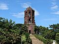
Bantay Bell Tower damaged by an earthquake
-
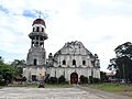
Saint Catherine of Alexandria Church in Tayum, Abra damaged by an earthquake
-
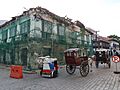
Calle Crisologo, Vigan, Ilocos Sur damaged by an earthquake
-
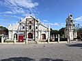
Earthquake damages Vigan Cathedral
-
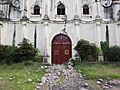
Damaged entrance of Saint Catherine of Alexandria Church
-
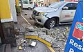
A vehicle damaged by falling debris.
-
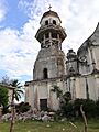
Damage on the bell tower of Saint Catherine of Alexandria Church
.jpg)
.jpg)
.jpg)
.jpg)
.jpg)

.jpg)
See also
- List of earthquakes in 2022
- List of earthquakes in the Philippines
