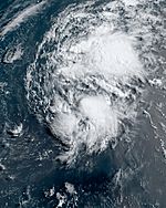
2023 Atlantic hurricane season facts for kids
Quick facts for kids 2023 Atlantic hurricane season |
|
|---|---|
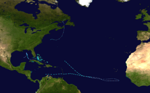
Season summary map
|
|
| Seasonal boundaries | |
| First system formed | Mid-January |
| Last system dissipated | Season ongoing |
| Seasonal statistics | |
| Total depressions | 4 |
| Total storms | 4 |
| Total fatalities | None |
| Total damage | Unknown |
| Related articles | |
|
|
The 2023 Atlantic hurricane season is the period when tropical storms and hurricanes form in the Atlantic Ocean. It officially started on June 1 and will end on November 30. These dates are chosen because most storms usually happen during this time. However, storms can form at any time of the year. For example, an unnamed subtropical storm formed in mid-January, which was a very early start for the season. Three named storms formed in June, which tied a record for that month. Two of these, Tropical Storm Bret and Tropical Storm Cindy, formed at almost the same time. This was the first time since 1968 that two storms were active together in June.
Contents
How Experts Predict Storms
Experts from different groups, like the United States National Oceanic and Atmospheric Administration (NOAA) and Colorado State University (CSU), try to guess how many storms will form each hurricane season. They look at many things to make their predictions.
A normal Atlantic hurricane season, based on data from 1991 to 2020, usually has about 14 tropical storms, 7 hurricanes, and 3 major hurricanes.
- A tropical storm has winds between 39 and 73 miles per hour (63–117 km/h).
- A hurricane has winds of 74 miles per hour (118 km/h) or more.
- A major hurricane is a very strong hurricane with winds of 111 miles per hour (178 km/h) or more.
Experts also use something called the "Accumulated Cyclone Energy" (ACE) index. This number measures how much power a storm has and how long it lasts. It's only calculated for storms that reach at least tropical storm strength. NOAA uses the ACE index to decide if a season is above-average, average, or below-average.
Early Predictions for the Season
Before the season officially began, many groups shared their predictions. Some thought it would be a slightly less active year, while others predicted a very busy season. For example, the University of Arizona thought there would be 19 named storms, but Tropical Storm Risk (TSR) predicted only 12 or 13.
These different predictions happened because experts weren't sure how two big things would affect the storms:
- An El Niño event, which can sometimes reduce hurricane activity.
- Very warm ocean waters, which can make storms stronger.
Mid-Season Predictions
Even after the season started, experts updated their predictions. On June 1, CSU slightly increased their forecast, expecting 15 named storms, 7 hurricanes, and 3 major hurricanes. They noticed that the ocean waters were still very warm, which could make up for the effects of El Niño.
What Happened So Far This Season

The 2023 Atlantic hurricane season officially started on June 1. But it had a surprise start in mid-January when a storm formed off the northeastern U.S. coast. Experts later found out it was a subtropical storm.
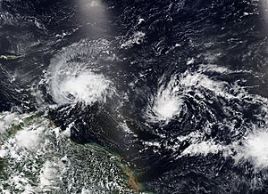
Tropical Storm Arlene was the first storm to get a name on June 2. Later that month, Tropical Storm Bret and Tropical Storm Cindy formed. This was special because it was the first time since 1968 that two Atlantic tropical storms were active at the same time in June. These two storms formed in a part of the ocean called the Main Development Region (MDR), from waves coming off the coast of West Africa. Bret formed farther east in the MDR than any other storm on record so early in the year. It was also the first time that two tropical storms formed in the MDR during June.
Storms of the Season
Unnamed Subtropical Storm
| Subtropical storm (SSHS) | |||
|---|---|---|---|
|
|||
| Duration | Mid-January – (TBD) | ||
| Intensity | Winds unknown, Unknown | ||
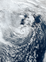
On January 16, the National Hurricane Center (NHC) started watching an area of low pressure north of Bermuda. Even though it had thunderstorms, experts thought it wouldn't become a tropical storm. These thunderstorms likely formed because the storm was over the Gulf Stream, where the water was warm, and there was cold air above it.
This storm brought snow to parts of New England and strong winds to Nova Scotia and Newfoundland in Canada. It then weakened and disappeared. Later, on May 11, after looking at all the information, the NHC decided that this system had actually been a subtropical storm. No damage was reported from this storm.
Tropical Storm Arlene
| Tropical storm (SSHS) | |||
|---|---|---|---|
|
|||
| Duration | June 1 – June 3 | ||
| Intensity | 40 mph (65 km/h) (1-min), 998 mbar (hPa) | ||
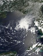
On May 30, the NHC started watching an area of bad weather in the Gulf of Mexico. It became Tropical Depression Two on June 1, near South Florida. On June 2, it got stronger and became Tropical Storm Arlene.
However, strong winds high in the atmosphere and dry air stopped Arlene from getting even stronger. It moved south through the Gulf of Mexico. On June 3, Arlene weakened back into a tropical depression and then disappeared.
Tropical Storm Bret
| Tropical storm | |
| Duration | June 19 – June 24 |
|---|---|
| Peak intensity | 70 mph (110 km/h) (1-min) 996 mbar (hPa) |
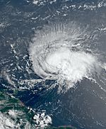
On June 15, the NHC began watching a tropical wave moving off the coast of West Africa. This system got more organized because the ocean water was warm and the air conditions were good. On June 19, it became Tropical Depression Three, and then Tropical Storm Bret later that day. It was about 1,295 miles (2,085 km) east of the southern Windward Islands.
Bret slowly got stronger as it moved west toward the Lesser Antilles. On June 22, experts found that Bret had winds of 70 miles per hour (110 km/h). Soon after, Bret moved into an area with stronger winds high up, which made it weaken. It passed just north of Barbados and directly over St. Vincent on June 22–23. Then, on June 24, Bret passed north of Aruba as a weakening storm and later broke apart near Colombia.
Bret brought strong winds and heavy rains to the Windward Islands. Over 120 people in Saint Vincent and the Grenadines went to shelters, and some homes were damaged or destroyed. In Saint Lucia, strong winds knocked out much of the island's electricity.
Tropical Storm Cindy
| Tropical storm | |
| Duration | June 22 – June 26 |
|---|---|
| Peak intensity | 60 mph (95 km/h) (1-min) 1001 mbar (hPa) |
On June 18, the NHC started tracking another tropical wave from West Africa. This system became Tropical Depression Four on June 22, about 1,395 miles (2,240 km) east of the Lesser Antilles. Even though the air conditions were not perfect, the depression strengthened into Tropical Storm Cindy early the next day.
On June 24, Cindy's winds reached 60 miles per hour (95 km/h). But later that day and into the next, the storm got weaker. On June 26, Cindy turned into a tropical wave about 375 miles (604 km) north-northeast of the Northern Leeward Islands. The NHC continued to watch its remains in case it tried to form again.
Storm Names for 2023
Here are the names that will be used for storms in the North Atlantic in 2023. This list is mostly the same as the one used in 2017, but some names like Harold, Idalia, Margot, and Nigel are new. They replaced names from 2017 that were retired because those storms caused a lot of damage.
If any names from this list are retired (meaning they won't be used again because the storm was very destructive), the World Meteorological Organization will announce it in the spring of 2024. The names that are not retired will be used again in the 2029 season.
|
|
|
Season Summary
This table shows all the storms that have formed in the 2023 Atlantic hurricane season so far. It includes how long they lasted, their names, how strong they were, the areas they affected, and any damage or deaths they caused.
| Saffir–Simpson Hurricane Scale | ||||||
| TD | TS | C1 | C2 | C3 | C4 | C5 |
| Storm name |
Dates active | Storm category
at peak intensity |
Max 1-min wind mph (km/h) |
Min. press. (mbar) |
Areas affected | Damage (USD) |
Deaths | Refs
|
||
|---|---|---|---|---|---|---|---|---|---|---|
| Unnamed | Mid-January | Subtropical storm | TBD | TBD | New England, Atlantic Canada | None | None | |||
| Arlene | June 1–3 | Tropical storm | 40 (65) | 998 | Florida | None | None | |||
| Bret | June 19–24 | Tropical storm | 70 (110) | 996 | Windward Islands, Leeward Antilles, Northern Venezuela, Northeastern Colombia | Minimal | None | |||
| Cindy | June 22–26 | Tropical storm | 60 (95) | 1001 | None | None | None | |||
| Season Aggregates | ||||||||||
| 4 systems | Mid-January – Season ongoing | – | – | Minimal | None | |||||
See also
 In Spanish: Temporada de huracanes en el Atlántico de 2023 para niños
- Weather of 2023
- Tropical cyclones in 2023
- 2023 Pacific hurricane season
- 2023 Pacific typhoon season
- 2023 North Indian Ocean cyclone season
- South-West Indian Ocean cyclone seasons: 2022–23, 2023–24
- Australian region cyclone seasons: 2022–23, 2023–24
- South Pacific cyclone seasons: 2022–23, 2023–24


