
2023 Marrakesh-Safi earthquake facts for kids
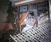
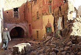
    Clockwise from top: Imi N'Tala, Moulay Brahim, Tizi N'Test and Tansghart after the earthquake
|
|
| UTC time | 2023-09-08 22:11:01 |
|---|---|
| ISC event | 626740945 |
| USGS-ANSS | ComCat |
| Local date | 8 September 2023 |
| Local time | 23:11 DST |
| Magnitude | 6.8 Mww, 6.9 Mw |
| Depth | 18.0 km (11.2 mi) |
| Epicenter | 31°04′23″N 8°24′25″W / 31.073°N 8.407°W |
| Type | Oblique-thrust |
| Areas affected | Morocco |
| Max. intensity | VIII (Severe) |
| Casualties | 2,960 killed, 5,674 injured |
On 8 September 2023, a strong earthquake hit Morocco's Marrakesh–Safi region. It happened at 23:11 local time. The earthquake was very powerful, measuring between 6.8 and 6.9 on the moment magnitude scale. The shaking was so strong it was rated as VIII (Severe) on the Mercalli intensity scale.
The earthquake's center, called the epicentre, was about 73.4 km (45.6 mi) southwest of the city of Marrakesh. It was near a town called Ighil in the Atlas Mountains. This earthquake happened because of rocks moving deep underground along a type of crack called a thrust fault. Sadly, at least 2,960 people died, mostly in areas outside Marrakesh. Many buildings were damaged, and old, important places in Marrakesh were destroyed. People in Spain, Portugal, and Algeria also felt the ground shake.
This was the strongest earthquake ever recorded in Morocco using scientific tools. It was also the deadliest earthquake in the country since the 1960 Agadir earthquake. In fact, it was the second deadliest earthquake in the world in 2023, after the one in Turkey and Syria. More than 2.8 million people were affected, including 100,000 children. Many countries offered help, and Morocco announced three days of national mourning to remember those who were lost.
Contents
Understanding Earthquakes in Morocco

Morocco is located near a major crack in the Earth's crust called the Azores–Gibraltar Transform Fault. This fault is where two huge pieces of the Earth's surface, called African and Eurasian Plates, meet. These plates are always moving, and sometimes they push against each other.
When these plates push together, it can create large cracks in the ground called thrust faults. Most earthquakes in Morocco happen because of this plate movement. The northern part of Morocco is at the highest risk for earthquakes. For example, in 2004, a magnitude 6.3 earthquake hit Al Hoceima, killing 628 people. A very strong magnitude 7.3 earthquake also hit nearby Algeria in 1980, causing 2,500 deaths.
The Atlas Mountains stretch for 2,000 km (1,200 mi) across Morocco and Tunisia. These mountains formed a long time ago when land masses collided. Earthquakes in the Atlas Mountains usually happen when rocks slide past each other or push upwards. Before this recent earthquake, the biggest one recorded in the Atlas Mountains was a magnitude 5.9 earthquake in Agadir in 1960.
The 2023 Earthquake

_2_(53174496053).png)
The Marrakesh–Safi earthquake was the strongest ever recorded in Morocco using modern instruments. It happened about 18.0 km (11.2 mi) deep underground. Different groups reported slightly different magnitudes, but it was around 6.8 to 6.9. The shaking was felt as far away as Egypt. People who experienced it said the ground shook for about 20 seconds.
After the main earthquake, smaller earthquakes called aftershocks occurred. One aftershock, measuring magnitude 4.9, happened just 19 minutes later. Another magnitude 4.5 aftershock was reported two days later.
Scientists believe the earthquake happened on a fault line under the High Atlas mountains. This fault caused the ground to move upwards and sideways. Satellite images showed that the land surface around the earthquake's center lifted by about 20 cm (7.9 in) in some places and sank by 7 cm (2.8 in) in others. This kind of movement happens when a hidden fault, called a blind thrust fault, moves deep underground.
The earthquake caused very strong shaking (Intensity VIII) for about 156,000 people, especially in villages near the Atlas Mountains. Over 873,000 people felt very strong shaking (Intensity VII), including many in Marrakesh. Millions more felt strong or moderate shaking in other cities like Taroudant, Ouarzazat, Agadir, and Casablanca. The earthquake was also felt in nearby countries like Portugal, Spain, and Algeria.
Impact of the Earthquake
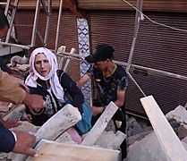
At least 2,960 people died and 5,674 were injured, with over 2,500 seriously hurt. Many people died in small, remote villages south of Marrakesh. The provinces of Al-Haouz and Taroudant were hit the hardest.
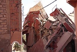
Many homes, especially in older parts of Marrakesh, and parts of the city walls collapsed. This trapped families under the rubble. At the famous Jemaa el-Fnaa square, a minaret (tower) of the Kharboush Mosque fell. The historic Kutubiyya Mosque was also damaged. Several buildings in the Medina of Marrakesh, a UNESCO World Heritage Site from the 12th century, also collapsed.
The ancient 12th-century Tinmel Mosque was almost completely destroyed. Its tower partly fell, and walls collapsed. In the village of Tinmel itself, 15 people died. The Interior Ministry said most of the damage happened in villages and not in big cities. Entire villages near the earthquake's center were flattened.
In places like Amizmiz, rescuers had to use their hands to dig through debris. Many traditional houses made of mud bricks were destroyed. In the village of Majat, nearly all 50 traditional houses were ruined, and dozens of people died. About 90% of houses in Asni were destroyed. Electricity and roads were also cut off in some areas.
Villages like Tafeghaghte, Adassil, and Imlil were severely damaged or destroyed. In Tafeghaghte, 90 out of 200 residents died. In Adassil, 32 students from one school were killed. Many homes were destroyed in villages outside Agadir. In Imi N'Tala, at least 70 people died. The city of Taroudant also saw nearly 200 deaths and severe damage to its old districts. Some remote villages had no electricity or phone service for days.
- Earthquake aftermath in Marrakesh and Moulay Brahim
-
-
-
-
-


What Happened After

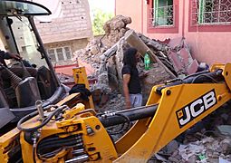
After the earthquake, people in Marrakesh started removing rubble by hand. Many stayed outside because they were afraid of another earthquake. Social media showed people leaving shopping centers and apartment buildings. Residents spent the first three nights sleeping outdoors in public spaces. Some businesses in the city reopened a few days later.
Moroccan officials and security teams quickly gathered resources to help. The Moroccan army cleared main roads to the worst-hit areas so aid could get through. Trucks carried blankets, beds, and lights to affected areas. Rescue efforts were difficult because roads in the mountains were blocked by traffic and fallen rocks. Buildings made of mud brick and wood collapsed into piles of rubble, making it hard to find survivors.
Hospitals in Marrakesh saw a large increase in injured people. People from outside the city also came for treatment. There was an urgent call for blood donations. Many people, including tourists and the Moroccan national football team, donated blood. This effort collected 6,000 bags of blood in just one day.
King Mohammed VI allowed the Royal Moroccan Army to help in affected cities. He also announced three days of national mourning and set up a special group to help survivors. The King also ordered special bank accounts to be opened for donations. The government promised to fund rebuilding and help those affected. The King visited a hospital in Marrakesh and donated blood. The monarchy announced that 50,000 houses were damaged and promised financial help for rebuilding. They also said that all children who lost their parents in the earthquake would become "Wards of the Nation," meaning the country would care for them.
The Army set up a field hospital in Moulay Brahim. Rescue workers used heavy equipment to find survivors and bodies. People in the village started digging graves on a hill to bury the dead. Large tents were set up to house those who lost their homes. Flights at Marrakesh Airport mostly continued as normal, but some flights were changed or canceled.
The Red Cross said that recovery from this earthquake could take years. Many villages in the remote mountains near the earthquake's center were completely flattened or hard to reach. The lack of good roads and hospitals in these areas made it harder to get help to people quickly.
See also
 In Spanish: Terremoto de Marrakech-Safí de 2023 para niños
- Lists of 21st-century earthquakes
- List of earthquakes in 2023
- List of earthquakes in Morocco
