Aberdeen, Maryland facts for kids
Quick facts for kids
Aberdeen, Maryland
|
|||
|---|---|---|---|

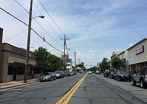
Bel Air Avenue in downtown Aberdeen, 2016.
|
|||
|
|||
| Nickname(s):
"All America City"
|
|||
| Motto(s):
"The Future of Harford!"
|
|||

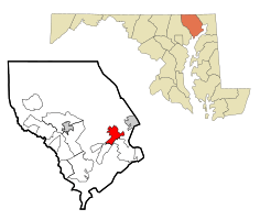
Location in Harford County, Maryland
|
|||
| Country | |||
| State | |||
| County | Harford | ||
| Incorporated | 1892 | ||
| Area | |||
| • Total | 6.60 sq mi (17.10 km2) | ||
| • Land | 6.59 sq mi (17.08 km2) | ||
| • Water | 0.01 sq mi (0.02 km2) | ||
| Elevation | 95 ft (29 m) | ||
| Population
(2020)
|
|||
| • Total | 16,254 | ||
| • Density | 2,464.59/sq mi (951.62/km2) | ||
| Time zone | UTC−5 (Eastern) | ||
| • Summer (DST) | UTC−4 (Eastern) | ||
| ZIP code |
21001
|
||
| Area code(s) | 410 | ||
| FIPS code | 24-00125 | ||
| GNIS feature ID | 0582854 | ||
Aberdeen is a city in Harford County, Maryland, United States. It is about 26 miles (42 km) northeast of Baltimore. In 2020, about 16,254 people lived there. Aberdeen is the biggest city in Harford County.
Aberdeen is part of the larger Baltimore-Towson area. This is one of the biggest city areas in the United States. The closest city to Aberdeen is Havre de Grace, which is about 4.8 miles (7.7 km) away.
Contents
History
Aberdeen got its name from Aberdeen, Scotland. This happened because many Scottish people moved here long ago.
Several historic places in Aberdeen are listed on the National Register of Historic Places. This means they are important for their history or architecture. Some of these are the James B. Baker House and Poplar Hill.
How Aberdeen Grew
Aberdeen started as a farming area around 1720. Charles Calvert, the fifth Lord Baltimore, gave a large piece of land to Edward Hall. The area was on a main road between Alexandria and Philadelphia. It was called the Old Post Road.
The village stayed small until 1835. That's when the Philadelphia, Wilmington and Baltimore Railroad looked for a place to stop trains. An engineer named Edmund Law Rogers saw how much the area could grow.
Around 1800, Edmund Law Rogers helped develop the "Village of Aberdeen." He named it after Aberdeen, Scotland. This was because his family had ties to the Earl of Aberdeen, who later became a Prime Minister.
Aberdeen today is a mix of three older communities:
- Hall's Cross Roads, where two old roads met.
- Mechanicsville.
- The Village of Aberdeen.
Becoming a City
In 1892, Aberdeen officially became a town. It was led by a group called a "board of commissioners." These leaders were elected every year or every two years.
In 1992, Aberdeen changed its rules and became a city. This meant it would now have an elected Mayor. Ruth Elliot was the first mayor of the City of Aberdeen. The current mayor, Patrick McGrady, was elected in 2015.
Geography
Aberdeen covers about 6.81 square miles (17.64 square km). Most of this area is land. Only a very small part is water.
The city is located at the northern end of the Upper Chesapeake Bay.
Climate
Aberdeen has a climate with hot, humid summers. The winters are usually mild to cool. This type of weather is called a humid subtropical climate.
| Climate data for Phillips Army Airfield (1991–2020 normals, extremes 1919–1957, 1966–present) | |||||||||||||
|---|---|---|---|---|---|---|---|---|---|---|---|---|---|
| Month | Jan | Feb | Mar | Apr | May | Jun | Jul | Aug | Sep | Oct | Nov | Dec | Year |
| Record high °F (°C) | 75 (24) |
81 (27) |
88 (31) |
94 (34) |
97 (36) |
100 (38) |
105 (41) |
102 (39) |
98 (37) |
95 (35) |
85 (29) |
74 (23) |
105 (41) |
| Mean daily maximum °F (°C) | 41.5 (5.3) |
44.1 (6.7) |
52.5 (11.4) |
64.8 (18.2) |
73.2 (22.9) |
82.1 (27.8) |
86.4 (30.2) |
84.4 (29.1) |
78.2 (25.7) |
66.9 (19.4) |
55.5 (13.1) |
45.8 (7.7) |
64.6 (18.1) |
| Daily mean °F (°C) | 33.4 (0.8) |
35.6 (2.0) |
42.8 (6.0) |
54.0 (12.2) |
62.9 (17.2) |
72.2 (22.3) |
77.1 (25.1) |
75.1 (23.9) |
68.5 (20.3) |
56.7 (13.7) |
46.1 (7.8) |
38.0 (3.3) |
55.2 (12.9) |
| Mean daily minimum °F (°C) | 25.3 (−3.7) |
27.1 (−2.7) |
33.1 (0.6) |
43.2 (6.2) |
52.7 (11.5) |
62.4 (16.9) |
67.7 (19.8) |
65.8 (18.8) |
58.8 (14.9) |
46.5 (8.1) |
36.8 (2.7) |
30.2 (−1.0) |
45.8 (7.7) |
| Record low °F (°C) | −12 (−24) |
−13 (−25) |
3 (−16) |
13 (−11) |
31 (−1) |
40 (4) |
48 (9) |
48 (9) |
34 (1) |
21 (−6) |
8 (−13) |
0 (−18) |
−13 (−25) |
| Average precipitation inches (mm) | 3.26 (83) |
2.78 (71) |
4.10 (104) |
3.49 (89) |
3.98 (101) |
4.28 (109) |
4.84 (123) |
4.21 (107) |
4.84 (123) |
4.17 (106) |
3.27 (83) |
3.89 (99) |
47.11 (1,197) |
| Source: NOAA | |||||||||||||
Attractions
B.&.O. Railroad Station
The B.&.O. Aberdeen Station is an old train station in downtown Aberdeen. It was built in 1885. The Historical Society of Harford County is working to save this important building.
Ripken Stadium
Ripken Stadium is where the Aberdeen IronBirds baseball team plays. It is named after famous baseball player Cal Ripken Jr.. Near the stadium is The Ripken Experience. This is a baseball complex with ten fields for youth tournaments and camps. The fields are smaller copies of real Major League Baseball stadiums.
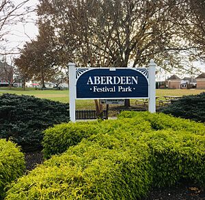
Aberdeen Festival Park
Aberdeen Festival Park is in the middle of downtown Aberdeen. Many city events happen here, like the Aberdeen Farmers Market. It has an outdoor field, a playground, and the APG Memorial.
Victory Street Park
Victory Street Park has a playground, a basketball court, and a disc-golf course. It also has a dog park for pets.
Population Information
| Historical population | |||
|---|---|---|---|
| Census | Pop. | %± | |
| 1880 | 101 | — | |
| 1890 | 448 | 343.6% | |
| 1900 | 600 | 33.9% | |
| 1910 | 616 | 2.7% | |
| 1920 | 1,067 | 73.2% | |
| 1930 | 1,240 | 16.2% | |
| 1940 | 1,525 | 23.0% | |
| 1950 | 2,944 | 93.0% | |
| 1960 | 9,679 | 228.8% | |
| 1970 | 12,375 | 27.9% | |
| 1980 | 11,533 | −6.8% | |
| 1990 | 13,087 | 13.5% | |
| 2000 | 13,842 | 5.8% | |
| 2010 | 14,959 | 8.1% | |
| 2020 | 16,254 | 8.7% | |
| U.S. Decennial Census | |||
2010 Census Data
In 2010, there were 14,959 people living in Aberdeen. There were 5,801 households, which are groups of people living together.
About 59% of the people were White, and 30.5% were African American. About 5.4% of the population was Hispanic or Latino.
About 34% of households had children under 18 living with them. The average household had about 2.57 people. The average age of people in the city was 38 years old.
Getting Around
Roads and Highways
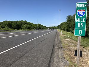
Many important roads go through Aberdeen. The biggest one is Interstate 95. This highway connects Aberdeen to major cities like Baltimore, Philadelphia, and New York City.
Maryland Route 22 also connects to I-95 and leads to the Aberdeen Proving Grounds. U.S. Route 40 is another main road that runs through the city.
Train Travel
Aberdeen has a train station on the Amtrak Northeast Corridor line. You can take Amtrak trains or Maryland Area Regional Commuter (MARC) trains from here.
The city is also near the East Coast Greenway. This is a network of trails for walking and biking. It connects many cities along the East Coast.
Local Buses
Aberdeen is part of the Harford Transit LINK bus system. Several bus routes connect Aberdeen to nearby towns like Havre de Grace and Bel Air. Route 4, called the Aberdeen Circulator, travels within the city itself.
Aberdeen Proving Ground
Aberdeen is home to the U.S. Army's Aberdeen Proving Ground (APG). This is a very large area where the Army tests new equipment. It started in 1918.
APG is the main place for the United States Army Test and Evaluation Command. Over 7,500 civilians and 5,000 military people work at APG.
Famous People and Groups
Many interesting people have connections to Aberdeen:
- William Benjamin Baker – A U.S. Congressman.
- Linwood Clark – Another U.S. Congressman, born in Aberdeen.
- Michael D. Griffin – A former head of NASA.
- E. J. Henderson and Erin Henderson – Football players for the Minnesota Vikings.
- Gary Neal – An NBA basketball player.
- Irv Pankey – A football player who played for the Los Angeles Rams.
- Cal Ripken Sr. – A longtime coach for the Baltimore Orioles baseball team.
- Billy Ripken – A baseball player for the Baltimore Orioles, and Cal Ripken Sr.'s son.
- Cal Ripken Jr. – A famous baseball player and Hall of Famer. He grew up in Aberdeen and went to Aberdeen High School.
- Frank Zappa – A famous musician who lived in Aberdeen for a short time.
- Ballyhoo! – A reggae rock band.
- Moor Mother – A musician, poet, and activist.
Aberdeen IronBirds
Cal Ripken Jr. and his brother Billy own the Aberdeen IronBirds. This is a minor league baseball team. They play their games at Ripken Stadium in Aberdeen.
Media
Aberdeen has its own local radio station, WAMD, at 970 AM. Local newspapers like The Aegis cover news in Harford County.
People in Aberdeen can watch Baltimore television stations. Sometimes, they can also get TV stations from Philadelphia and Harrisburg.
See also
 In Spanish: Aberdeen (Maryland) para niños


