Ada County, Idaho facts for kids
Quick facts for kids
Ada County
|
||
|---|---|---|

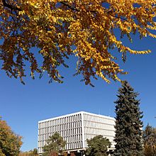
James A. McClure Federal Building and U.S. Courthouse in Boise, Idaho.
|
||
|
||

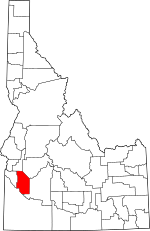
Location within the U.S. state of Idaho
|
||
 Idaho's location within the U.S. |
||
| Country | ||
| State | ||
| Founded | December 22, 1864 | |
| Named for | Ada Riggs | |
| Seat | Boise | |
| Largest city | Boise | |
| Area | ||
| • Total | 1,060 sq mi (2,700 km2) | |
| • Land | 1,053 sq mi (2,730 km2) | |
| • Water | 7.9 sq mi (20 km2) 0.7% | |
| Population
(2020)
|
||
| • Total | 494,967 | |
| • Estimate
(2022)
|
518,907 |
|
| • Density | 467.0/sq mi (180.3/km2) | |
| Time zone | UTC−7 (Mountain) | |
| • Summer (DST) | UTC−6 (MDT) | |
| Congressional districts | 1st, 2nd | |
| County Code: 1A | ||
Ada County is a county located in the southwestern part of Idaho, United States. It's the most populated county in Idaho. This means more people live here than in any other county in the state!
As of 2020, about 494,967 people lived in Ada County. By 2022, this number grew to an estimated 518,907. The county is home to over a quarter of Idaho's total population.
The main city and county seat is Boise. Boise is also the capital city of Idaho. Ada County is part of the larger Boise metropolitan area. This area includes Boise and its nearby cities and towns. The Ada County Highway District helps manage most local roads.
Contents
History of Ada County
Ada County was officially created on December 22, 1864. It was formed by the Idaho Territory legislature. The land for Ada County came from Boise County.
The county was named after Ada Riggs. She was the daughter of H. C. Riggs. He was a member of the legislature and helped create the county. He also helped start the city of Boise. Later, in 1891, Canyon County was formed from the western part of Ada County.
Geography and Nature
Ada County covers a total area of about 1,060 square miles. Most of this area, about 1,053 square miles, is land. The rest, about 7.9 square miles, is water.
The Boise River flows through the northern part of the county. The northwest edge of the county is next to the foothills of the Boise Range mountains. The highest parts of these mountains are in the neighboring Boise County. The southwestern border of Ada County is along the Snake River.
Neighboring Counties
Ada County shares borders with several other counties:
- Gem County - to the northwest
- Boise County - to the northeast
- Elmore County - to the east
- Owyhee County - to the south
- Canyon County - to the west
Main Roads and Highways
Many important roads run through Ada County. These roads help people travel around the county and to other parts of Idaho.
 - Interstate 84
 - Interstate 184
 - US 20
 - US 26
 - US 30
 - SH-16
 - SH-21 - Ponderosa Pine Scenic Byway
 - SH-44
 - SH-55 - Payette River Scenic Byway
 - SH-69
The Ada County Highway District is in charge of keeping these county roads and highways in good condition.
Protected Natural Areas
Parts of two important natural areas are found in Ada County:
- Boise National Forest
- Snake River Birds of Prey National Conservation Area
People and Population
| Historical population | |||
|---|---|---|---|
| Census | Pop. | %± | |
| 1870 | 2,675 | — | |
| 1880 | 4,674 | 74.7% | |
| 1890 | 8,368 | 79.0% | |
| 1900 | 11,559 | 38.1% | |
| 1910 | 29,088 | 151.6% | |
| 1920 | 35,213 | 21.1% | |
| 1930 | 37,925 | 7.7% | |
| 1940 | 50,401 | 32.9% | |
| 1950 | 70,649 | 40.2% | |
| 1960 | 93,460 | 32.3% | |
| 1970 | 112,230 | 20.1% | |
| 1980 | 173,036 | 54.2% | |
| 1990 | 205,775 | 18.9% | |
| 2000 | 300,904 | 46.2% | |
| 2010 | 392,365 | 30.4% | |
| 2020 | 494,967 | 26.1% | |
| 2023 (est.) | 524,673 | 33.7% | |
| U.S. Decennial Census 1790–1960 1900–1990 1990–2000 2010–2020 |
|||
In 2010, about 392,365 people lived in Ada County. Most people in the county were white (90.3%). Other groups included Asian (2.4%), Black or African American (1.1%), and American Indian (0.7%). About 7.1% of the population was of Hispanic or Latino background.
The average age of people in Ada County was 34.8 years old. This means half the people were younger than 34.8, and half were older.
Education in Ada County
Ada County has several public school districts. These districts manage the schools where kids go to learn.
- Public School Districts
- Boise School District
- Kuna Joint School District 3
- Melba Joint School District 136
- West Ada School District (also known as Meridian Joint School District 2)
Students who finish high school can also attend the College of Western Idaho. This college is located within the county.
Cities and Towns
Ada County has several cities and smaller communities.
Cities in Ada County
Special Communities
These are areas that are like towns but are not officially incorporated as cities. They are called "Census-designated places" (CDPs).
- Avimor
- Hidden Springs
Small Unincorporated Communities
These are even smaller areas that are not part of any city or CDP.
- Mora
- Pleasant Valley
- Sonna
Population of Cities and Towns
Here's a list of the cities and communities in Ada County, ranked by how many people live there. The numbers are based on the 2020 census and 2022 estimates.
† county seat
| Rank | Cities | Type | Population (2022 Estimate) |
Population (2020 Census) |
|---|---|---|---|---|
| 1 | † Boise | City | 236,634 | 235,684 |
| 2 | Meridian | City | 129,736 | 117,635 |
| 3 | Eagle | City | 32,399 | 30,346 |
| 4 | Kuna | City | 27,229 | 24,011 |
| 5 | Star | City | 14,646 | 11,117 |
| 6 | Garden City | City | 12,927 | 12,316 |
| 7 | Hidden Springs | CDP | — | 3,076 |
| 8 | Avimor | CDP | — | 1,255 |
See also
 In Spanish: Condado de Ada para niños
 | Mary Eliza Mahoney |
 | Susie King Taylor |
 | Ida Gray |
 | Eliza Ann Grier |


