
Akutan, Alaska facts for kids
Quick facts for kids
Akutan
Achan-ingiiga
|
|
|---|---|
 |
|

Akutan, Alaska
Location in Alaska

Akutan, Alaska
Location in North America
|
|
| Country | United States |
| State | Alaska |
| Borough | Aleutians East |
| Incorporated | 1979 |
| Area | |
| • Total | 147.90 sq mi (383.07 km2) |
| • Land | 65.98 sq mi (170.88 km2) |
| • Water | 81.93 sq mi (212.19 km2) |
| Elevation | 98 ft (30 m) |
| Population
(2020)
|
|
| • Total | 1,589 |
| • Density | 24.08/sq mi (9.30/km2) |
| Time zone | UTC-9 (Alaska (AKST)) |
| • Summer (DST) | UTC-8 (AKDT) |
| ZIP code |
99553
|
| Area code | 907 |
| FIPS code | 02-01090 |
| GNIS feature ID | 1418123 |
Akutan (/ˈækuːtæn/ AK-oo-tan, Aleut: Achan-ingiiga) is a city found on Akutan Island in the Aleutians East Borough of the Aleutian Islands in Alaska, United States. In 2020, its population was 1,589 people. This was a big jump from 1,027 people in 2010. This makes Akutan the 4th fastest-growing city in Alaska during that decade. Right next to the city is Akutan Harbor.
Contents
Geography
Akutan is located at 54°7′57″N 165°46′30″W / 54.13250°N 165.77500°W. It is part of the Aleutian Islands Recording District.
Location and Climate
Akutan is on Akutan Island in the eastern Aleutians. This island is one of the Krenitzin Islands in the Fox Islands group. It is about 35 miles (56 km) east of Unalaska. It is also about 766 miles (1,233 km) southwest of Anchorage.
The weather in Akutan is a maritime climate. This means it has mild winters and cool summers. Temperatures usually range from 22 to 55 degrees Fahrenheit (-6 to 13 degrees Celsius). The area gets about 28 inches (710 mm) of rain each year. Strong winds and storms are common in winter. Fog often covers the area in summer.
Size of the City
The city covers a total area of 18.9 square miles (48.9 km2). About 14.0 square miles (36.3 km2) of this is land. The remaining 4.9 square miles (12.7 km2), or about 25.69%, is water.
History and Culture
Akutan started in 1878 as a place to store and trade fur. A company agent began a business catching and processing cod fish. This quickly brought nearby Unangan people to live in the community. A Russian Orthodox church and a school were built in 1878. Later, the St. Alexander Nevsky Chapel was built in 1918.

Whaling Station
In 1912, the Pacific Whaling Company built a whale processing station. It was located across the bay from Akutan. This was the only whaling station in the Aleutian Islands. It operated until 1939.
World War II and the Akutan Zero
After Japanese forces attacked Unalaska in June 1942, the U.S. government moved Akutan residents away for safety. In June 1942, a Japanese A6M Zero fighter plane crashed on Akutan Island. It was flown by a pilot named Tadayoshi Koga. The United States Army Air Force found and recovered this plane in July. This plane became known as the Akutan Zero. It greatly helped American military experts. They learned how to fight against the Zero planes. This discovery helped change the direction of the war.
Community Changes
The village was re-established in 1944. However, many people chose not to return. Being exposed to the outside world brought many changes. It affected the traditional way of life and ideas in the community. Akutan officially became a city in 1979.
A group of Native people, the Native Village of Akutan, is recognized by the government here. About 16.4% of the people in Akutan are Alaska Native or partly Native. Akutan is mainly a fishing community. It is also the site of a traditional Unangan village. About 75 people live here all year. Most of the population are workers who come and go. They work in fish processing plants.
Population Information
| Historical population | |||
|---|---|---|---|
| Census | Pop. | %± | |
| 1880 | 65 | — | |
| 1890 | 80 | 23.1% | |
| 1920 | 66 | — | |
| 1930 | 71 | 7.6% | |
| 1940 | 80 | 12.7% | |
| 1950 | 86 | 7.5% | |
| 1960 | 107 | 24.4% | |
| 1970 | 101 | −5.6% | |
| 1980 | 169 | 67.3% | |
| 1990 | 589 | 248.5% | |
| 2000 | 713 | 21.1% | |
| 2010 | 1,027 | 44.0% | |
| 2020 | 1,589 | 54.7% | |
| U.S. Decennial Census | |||
Akutan first appeared in the U.S. Census in 1880. It was an unincorporated Aleut village. It had 65 residents then. It officially became a city in 1979. Since 1990, many residents have been of Asian descent. Akutan is one of only three places in Alaska with a large Asian population.
Public Services
Akutan has several public services for its residents.
Utilities
Water comes from a local stream and a dam built in 1927. The water is treated and sent to all homes. There are plans to build new dams and a larger water storage tank. Sewage goes to a community septic tank. The treated water then flows into the ocean. Trash is collected three times a week. A new landfill and incinerator were recently built. The city also recycles aluminum. Trident Seafoods, a large company, has its own water, sewer, and electricity systems. Akutan Electric Utility provides electricity to the city.
Education and Healthcare
There is one school in Akutan, called Akutan School. It is part of the Aleutians East Borough School District (AEBSD). About 18 students attend this school.
For healthcare, there is the Anesia Kudrin Memorial Clinic. It is a primary healthcare center. Eastern Aleutian Tribes Inc. runs this clinic. It is also an Emergency Care Center. Emergency services are provided by volunteers and a health aide. Sometimes, people needing more care are flown to Unalaska or Anchorage.
Transportation
Getting to and from Akutan is mainly by seaplane, private boats, or fishing vessels. The State Ferry visits once a month in summer. Cargo ships deliver goods weekly from Seattle. The city owns a landing craft, the M/V Akutan. Akutan does not have a regular airstrip because of the steep land. However, there is a seaplane base for planes that land on water. Helicopter service started in 2014. This connects Akutan to Akun Island, where Akutan Airport is located. Grant Aviation is the only airline flying from this airport to nearby Dutch Harbor.

Economy
The economy of Akutan mostly depends on commercial fish processing. This means catching and preparing fish for sale. Not many local people have jobs that last all year.
Fish Processing
Trident Seafoods runs a very large fish processing plant. It is located west of the city. This plant processes cod, crab, pollock, and makes fish meal. During the busiest processing months, the population of Akutan can become four or five times larger. This is because many workers come to the city. A few residents have permits for commercial fishing. They mainly catch halibut and other bottom-dwelling fish.
Local Foods
People in Akutan also get food from nature. This is called subsistence food. It includes seal, salmon, herring, halibut, clams, wild cattle, and game birds.
Taxes
- Sales: None
- Property: None
- Special: 1% Raw Fish Tax (City); 2% Raw Fish Tax (Borough)
Images for kids
-
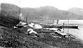
Whaling station along the harbor at Akutan ca. 1915
-
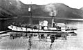
Whaler Unimak in Akutan Harbor, 1914. An American Pacific Sea Products Co. vessel
-

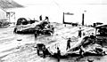
Men standing by dead whale at Akutan Harbor whaling station, 1914
-
Flensing whales at Akutan, ca. 1915
.jpeg)
.jpeg)
.jpeg)
.jpeg)
See also
 In Spanish: Akutan (Alaska) para niños
