Ampass facts for kids
Quick facts for kids
Ampass
|
||
|---|---|---|

Ampass
|
||
|
||

Location in the district
|
||
| Country | Austria | |
| State | Tyrol | |
| District | Innsbruck Land | |
| Area | ||
| • Total | 7.9 km2 (3.1 sq mi) | |
| Elevation | 651 m (2,136 ft) | |
| Time zone | UTC+1 (CET) | |
| • Summer (DST) | UTC+2 (CEST) | |
| Postal code |
6070
|
|
| Area code | 0512 | |
| Vehicle registration | IL | |
| Website | www.ampass.tirol.gv.at | |
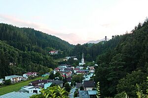
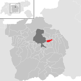
Ampass is a small town, also called a municipality, located in the Innsbruck-Land District in Tyrol, Austria. It sits at an elevation of 651 meters (about 2,136 feet) above sea level. Ampass covers an area of 7.9 square kilometers (about 3 square miles) and was home to 1,793 people as of January 2015.
Contents
Geography of Ampass
Ampass is found on a flat area, like a terrace, on the southern side of the Inn Valley. It's located on an old "salt road" that once connected Hall in Tirol to Matrei am Brenner. Today, this road is known as Landesstraße L 38. Ampass is also directly connected to Innsbruck, which is only about 8 kilometers (5 miles) away, by the road L 283.
On the edge of the village, you'll find the Taxerhof Lake. This lake is surrounded by reeds and a wet area, which makes it a great home for birds like herons and wagtails.
History of Ampass
Early Beginnings of Ampass
People likely lived in the Ampass area as far back as the 15th century BC. This is known because a burial urn from that time was found on a nearby hill. Even more ancient items, like arrowheads, bronze pins, and beads, have been discovered. These date back to the Hallstatt culture and La Tène Culture, showing a long history of human settlement.
The ancient Romans built a military road through Ampass. This road connected Hall in Tirol with Matrei am Brenner, passing through other towns like Igls, Sistrans, Lans, and Ampass. The only remaining sign of the Roman period is a large granite milestone. It's 1.9 meters (about 6 feet) tall and is still in its original spot. This stone was even used in 1254 to mark the boundary between two church areas, Wilten and Ampass.
Around the 7th century, like much of Tyrol, Ampass was affected by the invasion of the Bavarii people. Traces of their presence have been found in skeletons. In 1056, Emperor Henry IV, Holy Roman Emperor, who became emperor at just six years old, built a chapel in Ampass. This chapel was opened by the Bishop of Brixen, Altwin, and later became known as a "Royal Chapel."
Ampass Through the Centuries
The name "Ampass" first appeared in documents in 1145 as "Ambanes." This name comes from a Celtic word meaning "between two rivers." At that time, Ampass was under the control of the Court of Sonnenburg. In 1313, Ampass officially became its own municipality, meaning it could manage its own money. In that year, 22 families were listed as taxpayers.
As trade with the south grew, the old Roman road was repaired and made wider in 1552. However, in 1634, a serious illness called the plague struck the village, causing many people to die. To remember those who were lost, a special stone pillar called the "Viertelsäule" was put up along the road on the "Sonnenbühel" hill. This pillar has become the symbol of Ampass and is a very famous Gothic pillar in Tyrol.
During the Tyrolean rebellion, there were several battles in Ampass. Local fighters were led by Josef Speckbacher, Count Victor Dankl, and Kaspar Sautner, who was from Ampass. After winning against the Bavarians and the French, Ampass became part of the Hall in Tirol District Court. Between 1840 and the early 1900s, the number of people living in Ampass went down. This happened because Innsbruck was growing with new industries, and people moved there for better job chances. The "Viertelsäule" was damaged in 1876 by unknown people but was fixed and put back. It was restored again in 1906 and in 1997.
In recent years, Ampass has grown as a place for farming and as a residential community where people live.
Coat of Arms of Ampass
The coat of arms for Ampass has green and white stripes. In the middle, you can see the "Viertelsäule," which is the special pillar and symbol of Ampass. It was put up to remember the time of the plague. The two green stripes stand for the green meadows around the village. The white stripe represents the old "salt road" that passed through Ampass. This coat of arms was officially given to Ampass on January 22, 1974.
Population
| Historical population | ||
|---|---|---|
| Year | Pop. | ±% |
| 1869 | 421 | — |
| 1880 | 435 | +3.3% |
| 1890 | 438 | +0.7% |
| 1900 | 361 | −17.6% |
| 1910 | 472 | +30.7% |
| 1923 | 516 | +9.3% |
| 1934 | 530 | +2.7% |
| 1939 | 523 | −1.3% |
| 1951 | 621 | +18.7% |
| 1961 | 534 | −14.0% |
| 1971 | 930 | +74.2% |
| 1981 | 1,184 | +27.3% |
| 1991 | 1,158 | −2.2% |
| 2001 | 1,303 | +12.5% |
| 2011 | 1,644 | +26.2% |
| 2015 | 1,793 | +9.1% |
Sights to See in Ampass
Religious Buildings
St. John the Baptist's Parish Church
In 1056, Emperor Henry IV, Holy Roman Emperor built a chapel here. It was opened by Bishop Altwin of Brixen and later became a "Royal Chapel." In 1426, a new church was built in the Gothic style and was named after "St. John the Baptist." Sadly, this church was damaged by war in 1546 and then destroyed by fire in 1567.
The church was rebuilt and opened again in 1574. However, an earthquake in 1698 destroyed it once more. The church was then rebuilt in 1744 and was given a beautiful Baroque style.
St. Vitus's Church
A church dedicated to Saint Vitus was built in 1429. It was built by the carters, who were people who transported salt. In 1521, the church was rebuilt on its original foundations. Behind the altar, you can still see signs of the prayers made by the carters. During a restoration of the church, old paintings (frescoes) were found. These paintings included symbols of important historical figures like Charles V, Holy Roman Empire, and symbols of places like Aragon, Sicily, Hungary, and Bohemia.
See also
 In Spanish: Ampass para niños
 | Stephanie Wilson |
 | Charles Bolden |
 | Ronald McNair |
 | Frederick D. Gregory |


