Amritsar district facts for kids
Quick facts for kids
Amritsar district
|
|
|---|---|
|
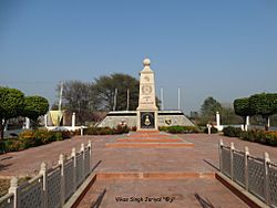
Clockwise from top-left: Harmandir Sahib, Attari-Wagah Border Crossing, Ajnala Fort, 1971 War memorial at Pul Kanjri
|
|

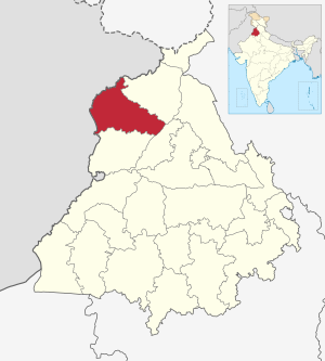
Location in Punjab
|
|
| Country | |
| State | Punjab |
| Named for | Suffice of Amrit |
| Headquarters | Amritsar |
| Area | |
| • Total | 2,683 km2 (1,036 sq mi) |
| Population | |
| • Total | 2,490,656 |
| • Density | 928.31/km2 (2,404.3/sq mi) |
| Languages | |
| • Official | Punjabi |
| Time zone | UTC+5:30 (IST) |
| Vehicle registration | PB-01(commercial) PB-02, PB-14, PB-17, PB-18, PB-81, PB-89 |
| Literacy (7+) | 76.27% |
Amritsar district is a district in the Punjab state of India. It is located in the Majha region of Punjab. The main city and headquarters of this district is Amritsar.
In 2011, Amritsar district was the second most populated district in Punjab. Only Ludhiana had more people.
Contents
History of Amritsar District
Early Control in the 1800s
By 1802, Maharaja Ranjit Singh took full control of Amritsar. He brought all the different groups, called Misls, under his rule. He also made the Gobindgarh fort stronger and more modern.
Amritsar During British Rule
During the time of British Rule, Amritsar District was part of the Lahore Division. It was divided into three smaller areas called tehsils: Amritsar, Ajnala, and Tarn Taran.
However, in 1947, when India was divided, Amritsar district became part of India. Some areas like Patti and Khem Karan were originally in Lahore District. But after the division, they joined Amritsar District. During this time, many people moved. A large number of Muslims living in the district moved to Pakistan. At the same time, Hindus and Sikhs from what became Pakistan moved to India. Before 1947, Sikhs and Hindus together made up about 52% of the population in Amritsar district.
Climate and Weather in Amritsar
Amritsar has a climate that is quite dry, like many parts of Northwestern India. It experiences four main seasons each year.
- Winter (December to March): Temperatures can drop to about -1°C (30°F).
- Summer (April to June): It gets very hot, with temperatures reaching up to 45°C (113°F).
- Monsoon (July to September): This is the rainy season.
- Post-Monsoon (October to November): The weather starts to cool down.
The district gets about 703.4 mm (27.7 inches) of rain each year. The coldest temperature ever recorded was -3.6°C (25.5°F) on December 9, 1996. The hottest was 47.8°C (118.0°F) on June 9, 1995. The official weather station is at the civil aerodrome in Rajasansi. Weather records there go back to November 15, 1947.
| Climate data for Amritsar Airport | |||||||||||||
|---|---|---|---|---|---|---|---|---|---|---|---|---|---|
| Month | Jan | Feb | Mar | Apr | May | Jun | Jul | Aug | Sep | Oct | Nov | Dec | Year |
| Record high °C (°F) | 26.8 (80.2) |
32.2 (90.0) |
36.2 (97.2) |
44.1 (111.4) |
47.7 (117.9) |
47.8 (118.0) |
45.6 (114.1) |
40.7 (105.3) |
40.6 (105.1) |
38.3 (100.9) |
34.2 (93.6) |
28.5 (83.3) |
47.8 (118.0) |
| Mean maximum °C (°F) | 23 (73) |
26.1 (79.0) |
32 (90) |
40.5 (104.9) |
44 (111) |
44.1 (111.4) |
39.8 (103.6) |
37.1 (98.8) |
36.8 (98.2) |
35.5 (95.9) |
30.5 (86.9) |
24.9 (76.8) |
45.2 (113.4) |
| Mean daily maximum °C (°F) | 18.4 (65.1) |
21.7 (71.1) |
26.8 (80.2) |
34.2 (93.6) |
39 (102) |
39 (102) |
35 (95) |
34.2 (93.6) |
34.1 (93.4) |
32 (90) |
27.1 (80.8) |
21.1 (70.0) |
30.2 (86.4) |
| Mean daily minimum °C (°F) | 3.4 (38.1) |
6.3 (43.3) |
10.9 (51.6) |
16.1 (61.0) |
21.3 (70.3) |
24.3 (75.7) |
25.3 (77.5) |
24.9 (76.8) |
22.1 (71.8) |
15.4 (59.7) |
8.7 (47.7) |
4.1 (39.4) |
15.2 (59.4) |
| Mean minimum °C (°F) | −0.5 (31.1) |
1.7 (35.1) |
5.6 (42.1) |
10.2 (50.4) |
15.8 (60.4) |
19.6 (67.3) |
21.7 (71.1) |
21.4 (70.5) |
17.8 (64.0) |
10.7 (51.3) |
4.2 (39.6) |
0.1 (32.2) |
−1.2 (29.8) |
| Record low °C (°F) | −2.9 (26.8) |
−2.6 (27.3) |
2 (36) |
6.4 (43.5) |
9.6 (49.3) |
15.6 (60.1) |
18.2 (64.8) |
18.8 (65.8) |
13 (55) |
7.3 (45.1) |
−0.6 (30.9) |
−3.6 (25.5) |
−3.6 (25.5) |
| Average rainfall mm (inches) | 26.2 (1.03) |
38.6 (1.52) |
38.4 (1.51) |
21.4 (0.84) |
26.7 (1.05) |
61.2 (2.41) |
210.1 (8.27) |
167.3 (6.59) |
77.5 (3.05) |
16.1 (0.63) |
6.3 (0.25) |
13.6 (0.54) |
703.4 (27.69) |
| Average rainy days (≥ 1.0 mm) | 2.1 | 3.3 | 3.2 | 2 | 2.4 | 3.8 | 8.6 | 6.9 | 3.5 | 1.1 | 0.6 | 1.4 | 38.9 |
| Average relative humidity (%) | 74 | 70 | 64 | 47 | 38 | 48 | 72 | 77 | 69 | 67 | 73 | 76 | 65 |
| Mean monthly sunshine hours | 181.7 | 192.7 | 219.4 | 265.0 | 294.7 | 269.0 | 215.5 | 227.7 | 240.8 | 253.2 | 220.1 | 182.2 | 2,762 |
People and Languages of Amritsar District
| Historical population | ||
|---|---|---|
| Year | Pop. | ±% p.a. |
| 1901 | 764,821 | — |
| 1911 | 657,936 | −1.49% |
| 1921 | 694,261 | +0.54% |
| 1931 | 834,497 | +1.86% |
| 1941 | 1,044,457 | +2.27% |
| 1951 | 880,667 | −1.69% |
| 1961 | 1,010,093 | +1.38% |
| 1971 | 1,209,374 | +1.82% |
| 1981 | 1,460,497 | +1.90% |
| 1991 | 1,698,090 | +1.52% |
| 2001 | 2,157,020 | +2.42% |
| 2011 | 2,490,656 | +1.45% |
| source: | ||
According to the 2011 population count, Amritsar district has 2,490,656 people. This number is similar to the population of the country of Kuwait. It is also about the same as the US state of Nevada.
About 1,684,770 people in Amritsar district can read and write. This means 76.27% of people aged 7 and older are literate. There are 889 females for every 1,000 males. About 30.95% of the population belongs to Scheduled Castes. In 2011, there were 488,898 homes in the district.
Religions in Amritsar District
| Religion in Amritsar district (2011) | ||||
|---|---|---|---|---|
| Religion | Percent | |||
| Sikhism | 68.94% | |||
| Hinduism | 27.74% | |||
| Christianity | 2.18% | |||
| Islam | 0.50% | |||
| Other or not stated | 0.64% | |||
In 2011, most people in Amritsar district were Sikhs, making up about 69% of the population. Hindus were the next largest group, at 28%. There were also smaller groups of Christians (2%) and Muslims.
Sikhs are the main religion in the countryside, with over 90% of the population. In cities, Hindus and Sikhs are found in almost equal numbers. Christianity is growing, especially among the Dalit community. Islam, which used to be a major religion here, is now a very small part of the population.
| Religion | Population (1941) | Percentage (1941) | Population (2011) | Percentage (2011) |
|---|---|---|---|---|
| Islam |
657,695 | 46.52% | 12,502 | 0.5% |
| Sikhism |
510,845 | 36.13% | 1,716,935 | 68.94% |
| Hinduism |
217,431 | 15.38% | 690,939 | 27.74% |
| Christianity |
25,330 | 1.79% | 54,344 | 2.18% |
| Others | 2,575 | 0.18% | 15,936 | 0.64% |
| Total Population | 1,413,876 | 100% | 2,490,656 | 100% |
Languages Spoken in Amritsar District
In 2011, almost everyone in Amritsar district spoke Punjabi as their first language (99.1%). A small number of people (0.8%) spoke Hindi. Most Hindi speakers live in the cities.
How Amritsar District is Governed
Amritsar district is managed by several important officials and bodies.
- The Deputy Commissioner: This person is an officer from the Indian Administrative Service. They are in charge of the district's general management. They also lead the police force as the District Magistrate. The current Deputy Commissioner of Amritsar is Harpreet Singh Sudan, appointed in 2022.
- Department Heads: Different departments like public works, health, education, and agriculture have their own district officers. These officers belong to various Punjab state services.
- The Commissioner of Police: This officer is from the Indian Police Service. They are responsible for keeping law and order in the district. They get help from other Punjab Police officers.
- The Divisional Forest Officer: This officer is from the Indian Forest Service. They manage the forests and wildlife in the district. They are helped by other forest and wildlife officials.
- Municipal Corporation: The city of Amritsar has a Municipal corporation. This group is in charge of public works and health services in the city. It is made up of elected councillors, and the Mayor leads them. Currently, there are over 70 councillors.
Amritsar District shares borders with several other areas. To the west, it borders the Pakistani Punjab Districts of Lahore, Kasur, and Shiekhupura along the Ravi River. To the south, it borders Tarn Taran District along the Sutlej River. Kapurthala District is to the east along the Beas River, and Gurdaspur District is to the north.
Tehsils in Amritsar District
A tehsil is a smaller administrative area within a district. As of the 2011 census, Amritsar district has four tehsils:
| # | Tehsil | District |
|---|---|---|
| 1 | Amritsar- II | Amritsar |
| 2 | Ajnala | Amritsar |
| 3 | Baba Bakala | Amritsar |
| 4 | Amritsar -I | Amritsar |
There are also two more tehsils: Majitha and Lopoke at Chogawan.
Politics in Amritsar District
The district has several areas called constituencies, each represented by an elected official.
| Constituency number |
Constituency name |
Reserved for (SC/None) |
Electors (2017) |
District |
|---|---|---|---|---|
| 15 | Amritsar North | None | 175,908 | Amritsar |
| 16 | Amritsar West | SC | 179,766 | Amritsar |
| 17 | Amritsar Central | None | 135,954 | Amritsar |
| 18 | Amritsar East | None | 153,629 | Amritsar |
| 19 | Amritsar South | None | 148,809 | Amritsar |
| 20 | Attari | SC | 173,543 | Amritsar |
Members of Legislative Assembly (MLAs)
Here are the current Members of Legislative Assembly (MLAs) for the Amritsar district. They represent different areas within the district.
| No. | Constituency | Name of MLA | Party | Bench | |
|---|---|---|---|---|---|
| 11 | Ajnala | Kuldip Singh Dhaliwal | Aam Aadmi Party | Government | |
| 12 | Rajasansi | Sukhbinder Singh Sarkaria | Indian National Congress | Opposition | |
| 13 | Majitha | Ganieve Kaur Majithia | Shiromani Akali Dal | Opposition | |
| 14 | Jandiala (SC) | Harbhajan Singh E.T.O. | Aam Aadmi Party | Government | |
| 15 | Amritsar North | Kunwar Vijay Pratap Singh | Aam Aadmi Party | Government | |
| 16 | Amritsar West (SC) | Jasbir Singh Sandhu | Aam Aadmi Party | Government | |
| 17 | Amritsar Central | Ajay Gupta | Aam Aadmi Party | Government | |
| 18 | Amritsar East | Jeevan Jyot Kaur | Aam Aadmi Party | Government | |
| 19 | Amritsar South | Inderbir Singh Nijjar | Aam Aadmi Party | Government | |
| 20 | Attari (SC) | Jaswinder Singh | Aam Aadmi Party | Government | |
| 25 | Baba Bakala (SC) | Dalbir Singh Tong | Aam Aadmi Party | Government | |
See also
 In Spanish: Distrito de Amritsar para niños
Images for kids
 | Roy Wilkins |
 | John Lewis |
 | Linda Carol Brown |


